You are here: Home > Network List > XN00 - RPI-UW Parkfield Calibration Array Stations List
> Station LEEP XN.LEEP > Earthquake Result Viewer
LEEP XN.LEEP - Earthquake Result Viewer
| Earthquake location: |
Chile-Bolivia Border Region |
| Earthquake latitude/longitude: |
-21.7/-68.3 |
| Earthquake time(UTC): |
2002/03/28 (087) 04:56:22 GMT |
| Earthquake Depth: |
125 km |
| Earthquake Magnitude: |
6.1 MB, 6.5 MW, 6.5 MW |
| Earthquake Catalog/Contributor: |
WHDF/NEIC |
|
| Network: |
XN RPI-UW Parkfield Calibration Array |
| Station: |
LEEP XN.LEEP |
| Lat/Lon: |
35.99 N/120.51 W |
| Elevation: |
1022 m |
|
| Distance: |
75.6 deg |
| Az: |
318.607 deg |
| Baz: |
130.671 deg |
| Ray Param: |
0.051219992 |
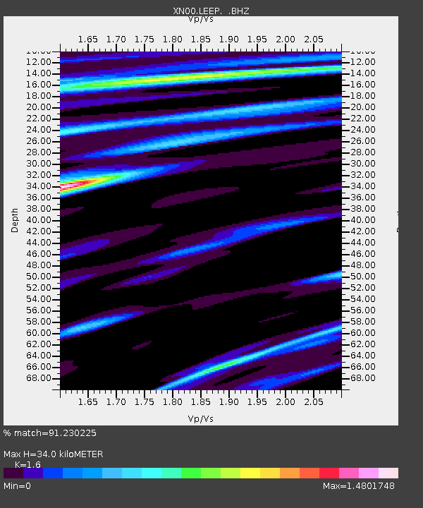
| Estimated Moho Depth: |
34.0 km |
| Estimated Crust Vp/Vs: |
1.60 |
| Assumed Crust Vp: |
6.183 km/s |
| Estimated Crust Vs: |
3.864 km/s |
| Estimated Crust Poisson's Ratio: |
0.18 |
|
| Radial Match: |
91.230225 % |
| Radial Bump: |
400 |
| Transverse Match: |
91.17003 % |
| Transverse Bump: |
400 |
| SOD ConfigId: |
16820 |
| Insert Time: |
2010-03-08 23:21:04.892 +0000 |
| GWidth: |
2.5 |
| Max Bumps: |
400 |
| Tol: |
0.001 |
|

Signal To Noise
| Channel | StoN | STA | LTA |
| XN:LEEP: :BHZ:20020328T05:07:22.850012Z | 2.3820512 | 8.0984603E-7 | 3.399784E-7 |
| XN:LEEP: :BHN:20020328T05:07:22.850012Z | 1.990346 | 8.0204126E-7 | 4.0296575E-7 |
| XN:LEEP: :BHE:20020328T05:07:22.850012Z | 4.314042 | 3.0467995E-6 | 7.062517E-7 |
| Arrivals |
| Ps | 3.4 SECOND |
| PpPs | 14 SECOND |
| PsPs/PpSs | 17 SECOND |


