
Station XN LEEP - XN.LEEP
Network: XN00 - RPI-UW Parkfield Calibration Array
Nearby stations (2 deg radius)
| Station | Name | (Lat, Lon) | Start / End | Elevation |
| LEEP | XN.LEEP | (35.99, -120.51) | 2001-06-24 / 2002-10-15 | 1022 m |
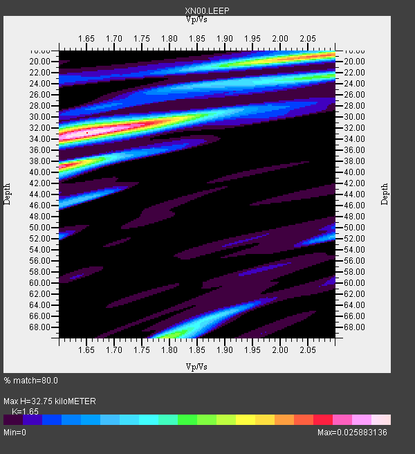
| Crust2 Type: | S1,continental slope, margin, transition 1 km seds. |
| Thickness Estimate: | 33 km |
| Thickness StdDev: | 11 km |
| Vp/Vs Estimate: | 1.65 |
| Vp/Vs StdDev: | 0.15 |
| Vs Estimate: | 3.747 km/s |
| Poisson's Ratio: | 0.21 |
| Peak Value: | 0.03 |
| Assumed Vp: | 6.183 km/s |
| Ps Weight: | 0.33333334 |
| PpPs Weight: | 0.33333334 |
| PsPs Weight: | 0.33333328 |
| Residual Complexity: | 0.680 |
| Nearby stations H: | 34 km +- 1.4 km |
| (2.0 deg) Vp/Vs: | 1.81 +- 0.23 |
3 with match > 90% ( 13.636364 %) and 8 with match > 80% ( 36.363636 %) out of 22.
Download stack as xyz text file.
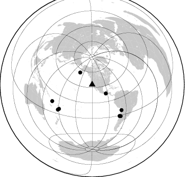
Azimuth Distribution of Events:
Prior Results for this Station
| Study | Thickness | Vp/Vs | Vp | Vs | Poissons Ratio | Extra |
| EARS | 33 km | 1.65 | 6.183 km/s | 3.747 km/s | 0.21 | |
| Crust2.0 | 23 km | 1.81 | 6.183 km/s | 3.422 km/s | 0.28 | S1,continental slope, margin, transition 1 km seds. |
| Global Maxima | 33 km | 1.65 | 6.183 km/s | 3.747 km/s | 0.21 | amp=0.025883136 |
| Local Maxima 1 | 39 km | 1.61 | 6.183 km/s | 3.852 km/s | 0.18 | amp=0.022425802 |
| Local Maxima 2 | 19 km | 2.03 | 6.183 km/s | 3.049 km/s | 0.34 | amp=0.017492328 |
| Local Maxima 3 | 70 km | 1.79 | 6.183 km/s | 3.449 km/s | 0.27 | amp=0.013756271 |
| Local Maxima 4 | 30 km | 1.81 | 6.183 km/s | 3.421 km/s | 0.28 | amp=0.009545647 |
| Predicted Arrivals for vertical incidence (zero ray parameter) | |
| Ps | 3.44 SECOND |
| PpPs | 14.04 SECOND |
| PsPs/PpSs | 17.48 SECOND |
Events Processed for this Station
Download zip of receiver functions as SAC
Plot maxima for each earthquake.
Events Used in the Stack
(8 events)| Radial Match | Distance | Baz | FERegion | Time | Lat/Lon | Depth | Magnitude |
| 91.230225 | 75.6 deg | 130.671 deg | Chile-Bolivia Border Region | 2002/03/28 04:56:22 GMT | (-21.7, -68.3) | 125 km | 6.1 MB, 6.5 MW, 6.5 MW |
| 90.58585 | 80.0 deg | 234.045 deg | Fiji Islands Region | 2002/08/19 11:01:01 GMT | (-21.7, -179.5) | 580 km | 6.7 MB, 7.6 MW, 7.7 ME |
| 90.18005 | 33.3 deg | 315.269 deg | South Of Alaska | 2002/05/25 05:36:31 GMT | (53.8, -161.1) | 33 km | 5.5 MB, 6.1 MS, 6.5 MW, 6.4 MW |
| 85.91465 | 84.2 deg | 247.712 deg | Vanuatu Islands | 2002/04/11 21:56:56 GMT | (-14.4, 167.7) | 10 km | 5.9 MB, 6.2 MS, 6.2 MW, 6.1 MW |
| 85.766914 | 82.6 deg | 233.986 deg | South Of Fiji Islands | 2002/08/19 11:03:13 GMT | (-23.6, 178.5) | 650 km | 5.9 MB |
| 83.95423 | 81.0 deg | 138.606 deg | Near Coast Of Central Chile | 2002/06/18 13:56:22 GMT | (-30.8, -71.1) | 54 km | 6.0 MB, 6.6 MW, 6.4 MW |
| 83.91173 | 82.6 deg | 137.767 deg | San Juan Province, Argentina | 2002/09/24 03:57:22 GMT | (-31.5, -69.2) | 120 km | 6.2 MB, 6.4 MW, 6.3 MW |
| 80.32983 | 31.8 deg | 122.659 deg | Near Coast Of Chiapas, Mexico | 2001/11/28 14:32:32 GMT | (15.6, -93.1) | 85 km | 5.7 MB, 6.4 MW, 6.4 MW |
Losers
(14 events)| Radial Match | Distance | Baz | FERegion | Time | Lat/Lon | Depth | Magnitude | Reason |
| 88.38347 | 42.9 deg | 120.161 deg | Costa Rica | 2002/06/16 02:46:14 GMT | (8.8, -84.0) | 35 km | 5.4 MB, 6.2 MS, 6.4 MW, 6.4 MW | |
| 86.45406 | 77.4 deg | 316.613 deg | Northeastern China | 2002/09/15 08:39:32 GMT | (44.8, 129.9) | 586 km | 5.8 MB, 6.4 MW, 6.4 MW | |
| 80.452385 | 86.5 deg | 242.957 deg | Vanuatu Islands | 2002/08/12 02:59:24 GMT | (-19.5, 169.0) | 112 km | 5.6 MB, 6.0 MW, 5.9 MW | |
| 77.25536 | 82.0 deg | 134.485 deg | Catamarca Province, Argentina | 2002/05/28 04:04:22 GMT | (-28.9, -66.8) | 22 km | 6.0 MB, 5.7 MS, 6.0 MW, 5.9 MW | |
| 71.917046 | 84.1 deg | 249.912 deg | Santa Cruz Islands | 2002/06/17 21:26:22 GMT | (-12.6, 166.4) | 33 km | 6.0 MB, 6.7 MS, 6.7 MW, 6.6 MW | |
| 70.32851 | 81.1 deg | 299.6 deg | Southeast Of Honshu, Japan | 2002/08/02 23:11:39 GMT | (29.3, 139.0) | 426 km | 5.5 MB, 6.3 MW, 6.3 MW | |
| 69.77566 | 78.2 deg | 231.935 deg | Fiji Islands Region | 2002/08/07 04:50:06 GMT | (-21.9, -176.6) | 174 km | 5.4 MB, 5.8 MW, 5.7 MW | |
| 68.97087 | 95.8 deg | 305.212 deg | Taiwan Region | 2002/05/28 16:45:17 GMT | (24.1, 122.3) | 33 km | 5.8 MB, 5.9 MS, 6.0 MW, 6.0 MW | |
| 68.953735 | 85.8 deg | 243.411 deg | Vanuatu Islands | 2002/10/07 19:00:31 GMT | (-18.7, 169.3) | 246 km | 5.4 MB, 5.7 MW, 5.6 MW | |
| 68.5827 | 85.2 deg | 226.324 deg | Kermadec Islands, New Zealand | 2002/08/13 14:13:54 GMT | (-30.8, -177.4) | 33 km | 5.4 MB, 5.5 MS, 5.6 MW, 5.6 MW | |
| 66.159325 | 86.8 deg | 254.665 deg | Solomon Islands | 2002/09/24 04:13:11 GMT | (-10.5, 161.2) | 10 km | 5.5 MB, 6.2 MS, 6.0 MW, 5.9 MW | |
| 63.077553 | 76.8 deg | 236.238 deg | Fiji Islands Region | 2002/06/16 06:55:13 GMT | (-17.9, -178.7) | 569 km | 5.7 MB, 5.9 MW, 5.9 MW | |
| 60.75759 | 76.8 deg | 236.243 deg | Fiji Islands Region | 2002/05/04 07:00:48 GMT | (-17.9, -178.7) | 560 km | 5.3 MB, 5.8 MW, 5.7 MW | |
| 47.999023 | 80.1 deg | 233.859 deg | Fiji Islands Region | 2002/08/19 11:45:29 GMT | (-21.9, -179.4) | 600 km | 5.5 MB |
