You are here: Home > Network List > XN00 - RPI-UW Parkfield Calibration Array Stations List
> Station MOH9 XN.MOH9 > Earthquake Result Viewer
MOH9 XN.MOH9 - Earthquake Result Viewer
| Earthquake location: |
Near Coast Of Chiapas, Mexico |
| Earthquake latitude/longitude: |
15.6/-93.1 |
| Earthquake time(UTC): |
2001/11/28 (332) 14:32:32 GMT |
| Earthquake Depth: |
85 km |
| Earthquake Magnitude: |
5.7 MB, 6.4 MW, 6.4 MW |
| Earthquake Catalog/Contributor: |
WHDF/NEIC |
|
| Network: |
XN RPI-UW Parkfield Calibration Array |
| Station: |
MOH9 XN.MOH9 |
| Lat/Lon: |
35.97 N/120.57 W |
| Elevation: |
672 m |
|
| Distance: |
31.8 deg |
| Az: |
314.813 deg |
| Baz: |
122.555 deg |
| Ray Param: |
0.078699216 |
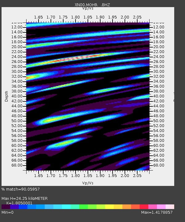
| Estimated Moho Depth: |
24.25 km |
| Estimated Crust Vp/Vs: |
1.81 |
| Assumed Crust Vp: |
6.183 km/s |
| Estimated Crust Vs: |
3.425 km/s |
| Estimated Crust Poisson's Ratio: |
0.28 |
|
| Radial Match: |
90.05957 % |
| Radial Bump: |
400 |
| Transverse Match: |
85.073006 % |
| Transverse Bump: |
400 |
| SOD ConfigId: |
16820 |
| Insert Time: |
2010-03-08 23:21:28.156 +0000 |
| GWidth: |
2.5 |
| Max Bumps: |
400 |
| Tol: |
0.001 |
|

Signal To Noise
| Channel | StoN | STA | LTA |
| XN:MOH9: :BHZ:20011128T14:38:19.148009Z | 1.6365199 | 3.3150536E-7 | 2.0256726E-7 |
| XN:MOH9: :BHN:20011128T14:38:19.148009Z | 3.2182362 | 6.3457867E-7 | 1.9718213E-7 |
| XN:MOH9: :BHE:20011128T14:38:19.148009Z | 2.662314 | 4.9096246E-7 | 1.8441193E-7 |
| Arrivals |
| Ps | 3.4 SECOND |
| PpPs | 10 SECOND |
| PsPs/PpSs | 14 SECOND |


