
Station XN MOH9 - XN.MOH9
Network: XN00 - RPI-UW Parkfield Calibration Array
Nearby stations (2 deg radius)
| Station | Name | (Lat, Lon) | Start / End | Elevation |
| MOH9 | XN.MOH9 | (35.97, -120.57) | 2001-06-24 / 2002-10-15 | 672 m |
| Crust2 Type: | S1,continental slope, margin, transition 1 km seds. |
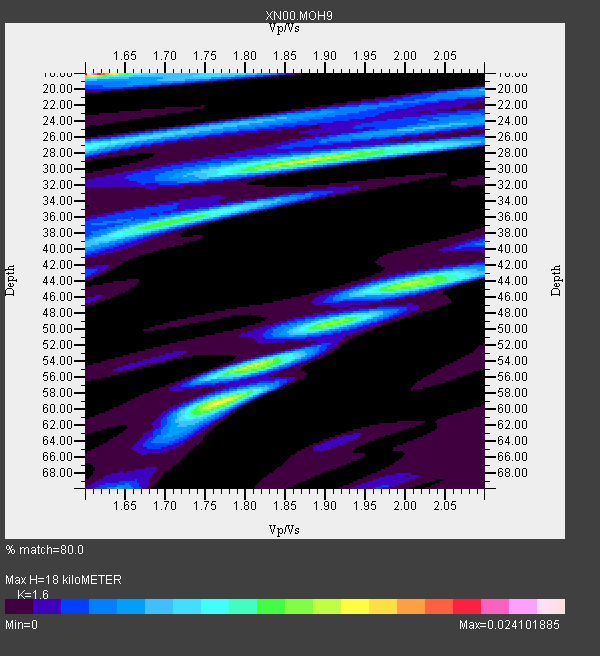
| Thickness Estimate: | 18 km |
| Thickness StdDev: | 15 km |
| Vp/Vs Estimate: | 1.60 |
| Vp/Vs StdDev: | 0.13 |
| Vs Estimate: | 3.864 km/s |
| Poisson's Ratio: | 0.18 |
| Peak Value: | 0.02 |
| Assumed Vp: | 6.183 km/s |
| Ps Weight: | 0.33333334 |
| PpPs Weight: | 0.33333334 |
| PsPs Weight: | 0.33333328 |
| Residual Complexity: | 0.936 |
| Nearby stations H: | 28 km +- 12 km |
| (2.0 deg) Vp/Vs: | 1.67 +- 0.13 |
4 with match > 90% ( 11.428572 %) and 14 with match > 80% ( 40.0 %) out of 35.
Download stack as xyz text file.
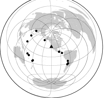
Azimuth Distribution of Events:
Prior Results for this Station
| Study | Thickness | Vp/Vs | Vp | Vs | Poissons Ratio | Extra |
| EARS | 18 km | 1.60 | 6.183 km/s | 3.864 km/s | 0.18 | |
| Crust2.0 | 23 km | 1.81 | 6.183 km/s | 3.422 km/s | 0.28 | S1,continental slope, margin, transition 1 km seds. |
| Global Maxima | 18 km | 1.60 | 6.183 km/s | 3.864 km/s | 0.18 | amp=0.024101885 |
| Local Maxima 1 | 29 km | 1.88 | 6.183 km/s | 3.28 km/s | 0.30 | amp=0.014726148 |
| Local Maxima 2 | 59 km | 1.77 | 6.183 km/s | 3.498 km/s | 0.26 | amp=0.014395509 |
| Local Maxima 3 | 44 km | 2.00 | 6.183 km/s | 3.095 km/s | 0.33 | amp=0.0120934285 |
| Local Maxima 4 | 36 km | 1.73 | 6.183 km/s | 3.569 km/s | 0.25 | amp=0.009535284 |
| Predicted Arrivals for vertical incidence (zero ray parameter) | |
| Ps | 1.75 SECOND |
| PpPs | 7.57 SECOND |
| PsPs/PpSs | 9.32 SECOND |
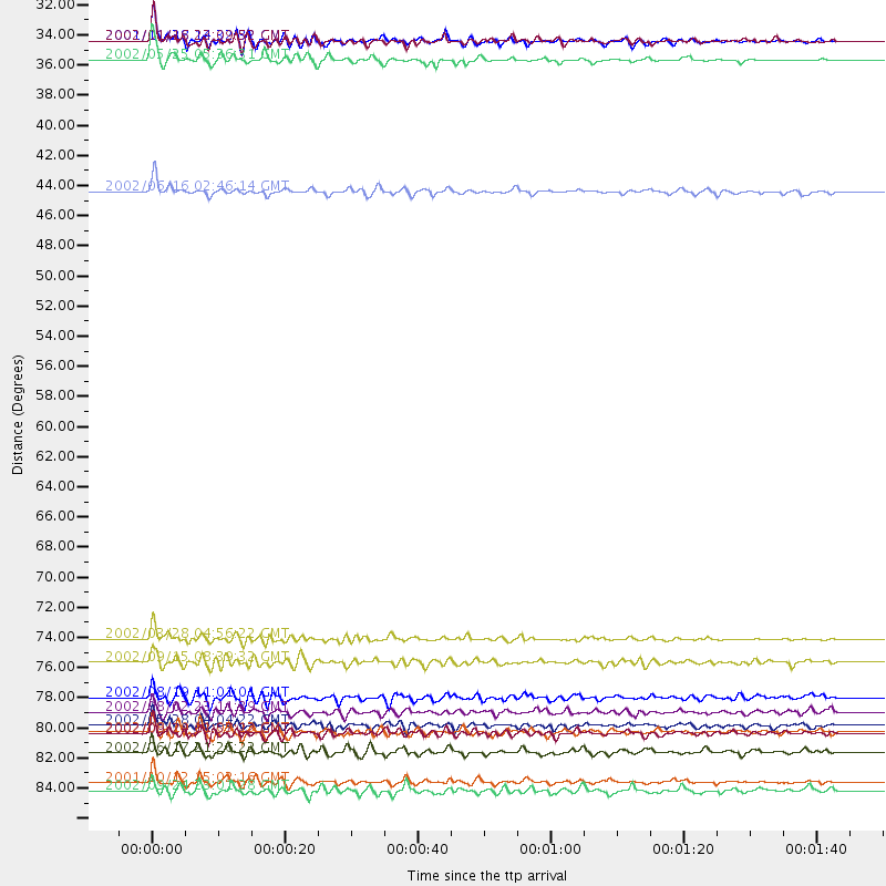
Events Processed for this Station
Download zip of receiver functions as SAC
Plot maxima for each earthquake.
Events Used in the Stack
(14 events)| Radial Match | Distance | Baz | FERegion | Time | Lat/Lon | Depth | Magnitude |
| 94.345505 | 86.2 deg | 282.815 deg | South Of Mariana Islands | 2001/10/12 15:02:16 GMT | (12.7, 145.0) | 37 km | 6.7 MB, 7.3 MS, 7.0 MW, 6.9 MW |
| 91.4168 | 80.0 deg | 234.007 deg | Fiji Islands Region | 2002/08/19 11:01:01 GMT | (-21.7, -179.5) | 580 km | 6.7 MB, 7.6 MW, 7.7 ME |
| 91.36993 | 33.2 deg | 315.307 deg | South Of Alaska | 2002/05/25 05:36:31 GMT | (53.8, -161.1) | 33 km | 5.5 MB, 6.1 MS, 6.5 MW, 6.4 MW |
| 90.05957 | 31.8 deg | 122.555 deg | Near Coast Of Chiapas, Mexico | 2001/11/28 14:32:32 GMT | (15.6, -93.1) | 85 km | 5.7 MB, 6.4 MW, 6.4 MW |
| 89.72148 | 42.9 deg | 120.081 deg | Costa Rica | 2002/06/16 02:46:14 GMT | (8.8, -84.0) | 35 km | 5.4 MB, 6.2 MS, 6.4 MW, 6.4 MW |
| 89.58499 | 77.4 deg | 316.589 deg | Northeastern China | 2002/09/15 08:39:32 GMT | (44.8, 129.9) | 586 km | 5.8 MB, 6.4 MW, 6.4 MW |
| 85.32855 | 86.8 deg | 254.533 deg | Solomon Islands | 2002/09/24 23:01:28 GMT | (-10.6, 161.2) | 19 km | 5.7 MB, 6.5 MS, 6.3 MW, 6.3 MW |
| 84.33272 | 75.7 deg | 130.624 deg | Chile-Bolivia Border Region | 2002/03/28 04:56:22 GMT | (-21.7, -68.3) | 125 km | 6.1 MB, 6.5 MW, 6.5 MW |
| 84.11049 | 82.6 deg | 233.949 deg | South Of Fiji Islands | 2002/08/19 11:03:13 GMT | (-23.6, 178.5) | 650 km | 5.9 MB |
| 83.338425 | 31.9 deg | 122.682 deg | Near Coast Of Chiapas, Mexico | 2002/01/16 23:09:52 GMT | (15.5, -93.1) | 80 km | 5.8 MB, 6.4 MW, 6.4 MW |
| 82.3785 | 82.0 deg | 134.443 deg | Catamarca Province, Argentina | 2002/05/28 04:04:22 GMT | (-28.9, -66.8) | 22 km | 6.0 MB, 5.7 MS, 6.0 MW, 5.9 MW |
| 81.99952 | 84.0 deg | 249.877 deg | Santa Cruz Islands | 2002/06/17 21:26:22 GMT | (-12.6, 166.4) | 33 km | 6.0 MB, 6.7 MS, 6.7 MW, 6.6 MW |
| 81.40626 | 82.6 deg | 137.725 deg | San Juan Province, Argentina | 2002/09/24 03:57:22 GMT | (-31.5, -69.2) | 120 km | 6.2 MB, 6.4 MW, 6.3 MW |
| 80.531166 | 81.0 deg | 299.571 deg | Southeast Of Honshu, Japan | 2002/08/02 23:11:39 GMT | (29.3, 139.0) | 426 km | 5.5 MB, 6.3 MW, 6.3 MW |
Losers
(21 events)| Radial Match | Distance | Baz | FERegion | Time | Lat/Lon | Depth | Magnitude | Reason |
| 85.2534 | 42.8 deg | 157.418 deg | Central East Pacific Rise | 2002/06/17 13:25:56 GMT | (-4.7, -105.4) | 10 km | 5.6 MS, 5.2 MB, 6.1 MW | |
| 78.522316 | 86.4 deg | 242.921 deg | Vanuatu Islands | 2002/08/12 02:59:24 GMT | (-19.5, 169.0) | 112 km | 5.6 MB, 6.0 MW, 5.9 MW | |
| 77.45532 | 81.0 deg | 138.563 deg | Near Coast Of Central Chile | 2002/06/18 13:56:22 GMT | (-30.8, -71.1) | 54 km | 6.0 MB, 6.6 MW, 6.4 MW | |
| 76.36314 | 44.1 deg | 119.435 deg | Panama-Costa Rica Border Region | 2002/08/03 02:39:01 GMT | (8.3, -82.8) | 10 km | 5.4 MB, 5.5 MS, 5.9 MW, 5.7 MW | |
| 74.55594 | 76.7 deg | 236.2 deg | Fiji Islands Region | 2002/06/16 06:55:13 GMT | (-17.9, -178.7) | 569 km | 5.7 MB, 5.9 MW, 5.9 MW | |
| 74.36845 | 49.9 deg | 117.891 deg | Near West Coast Of Colombia | 2002/08/08 13:39:58 GMT | (5.0, -77.8) | 43 km | 5.4 MB, 5.0 MS, 5.9 MW, 5.7 MW | |
| 73.17339 | 81.1 deg | 234.467 deg | South Of Fiji Islands | 2002/06/30 21:29:36 GMT | (-22.2, 179.2) | 620 km | 5.5 MB, 6.5 MW, 6.4 MW | |
| 66.60373 | 78.2 deg | 231.896 deg | Fiji Islands Region | 2002/08/07 04:50:06 GMT | (-21.9, -176.6) | 174 km | 5.4 MB, 5.8 MW, 5.7 MW | |
| 63.010864 | 93.8 deg | 190.986 deg | Pacific-Antarctic Ridge | 2002/07/19 06:43:55 GMT | (-56.6, -140.7) | 10 km | 5.6 MS, 5.1 MB, 6.1 MW, 6.0 MW | |
| 61.622437 | 80.1 deg | 233.821 deg | Fiji Islands Region | 2002/08/19 11:45:29 GMT | (-21.9, -179.4) | 600 km | 5.5 MB | |
| 60.53648 | 88.3 deg | 152.967 deg | Off Coast Of Southern Chile | 2002/08/04 09:50:25 GMT | (-45.0, -80.7) | 10 km | 5.5 MB, 4.9 MS, 5.9 MW, 5.7 MW | |
| 59.16463 | 47.0 deg | 126.309 deg | Off Coast Of Central America | 2002/08/31 05:27:18 GMT | (2.7, -84.4) | 23 km | 5.7 MB, 5.1 MS, 5.6 MW, 5.5 MW | |
| 57.206753 | 95.1 deg | 305.955 deg | Taiwan Region | 2002/09/16 00:03:29 GMT | (25.2, 122.3) | 183 km | 5.6 MW, 5.3 MB, 5.5 MW | |
| 56.68133 | 72.9 deg | 236.192 deg | Tonga Islands | 2002/06/21 14:21:44 GMT | (-15.1, -175.9) | 319 km | 5.7 MB, 5.7 MW, 5.7 MW | |
| 55.105907 | 86.8 deg | 254.237 deg | Solomon Islands | 2002/09/28 13:53:16 GMT | (-10.9, 161.4) | 10 km | 5.5 MS, 5.2 MB, 5.7 MW, 5.6 MW | |
| 54.11298 | 82.0 deg | 139.177 deg | Chile-Argentina Border Region | 2002/05/24 00:23:15 GMT | (-32.0, -70.9) | 60 km | 5.3 MB, 5.7 MW, 5.6 MW | |
| 53.989838 | 76.8 deg | 236.205 deg | Fiji Islands Region | 2002/05/04 07:00:48 GMT | (-17.9, -178.7) | 560 km | 5.3 MB, 5.8 MW, 5.7 MW | |
| 53.404896 | 68.7 deg | 308.287 deg | Kuril Islands | 2002/08/24 18:40:53 GMT | (43.1, 146.1) | 43 km | 5.9 MB, 5.8 MS, 6.2 MW, 6.1 MW | |
| 52.89217 | 94.6 deg | 267.161 deg | Eastern New Guinea Reg., P.N.G. | 2002/07/03 23:00:18 GMT | (-5.0, 147.3) | 31 km | 5.6 MB, 6.2 MS, 6.2 MW, 6.2 MW | |
| 50.688297 | 91.8 deg | 270.311 deg | Admiralty Islands Region, P.N.G. | 2002/09/04 14:34:15 GMT | (-0.8, 147.8) | 10 km | 5.8 MB, 5.1 MS, 5.6 MW, 5.5 MW | |
| 36.569912 | 85.7 deg | 243.375 deg | Vanuatu Islands | 2002/10/07 19:00:31 GMT | (-18.7, 169.3) | 246 km | 5.4 MB, 5.7 MW, 5.6 MW |
