You are here: Home > Network List > SP - South Carolina Earth Physics Project Stations List
> Station BLACK Blackville-Hilda High School, Barnwell County, SC USA > Earthquake Result Viewer
BLACK Blackville-Hilda High School, Barnwell County, SC USA - Earthquake Result Viewer

| Earthquake location: |
Northwest Of Kuril Islands |
| Earthquake latitude/longitude: |
47.8/146.2 |
| Earthquake time(UTC): |
2002/11/17 (321) 04:53:53 GMT |
| Earthquake Depth: |
459 km |
| Earthquake Magnitude: |
7.3 MW, 7.3 MW |
| Earthquake Catalog/Contributor: |
WHDF/NEIC |
|
| Network: |
SP South Carolina Earth Physics Project |
| Station: |
BLACK Blackville-Hilda High School, Barnwell County, SC USA |
| Lat/Lon: |
33.36 N/81.26 W |
| Elevation: |
94 m |
|
| Distance: |
88.7 deg |
| Az: |
38.091 deg |
| Baz: |
330.214 deg |
| Ray Param: |
0.041681953 |
| Estimated Moho Depth: |
33.25 km |
| Estimated Crust Vp/Vs: |
1.83 |
| Assumed Crust Vp: |
6.565 km/s |
| Estimated Crust Vs: |
3.587 km/s |
| Estimated Crust Poisson's Ratio: |
0.29 |
|
| Radial Match: |
88.06119 % |
| Radial Bump: |
400 |
| Transverse Match: |
60.11158 % |
| Transverse Bump: |
400 |
| SOD ConfigId: |
2217 |
| Insert Time: |
2010-02-25 16:35:48.527 +0000 |
| GWidth: |
2.5 |
| Max Bumps: |
400 |
| Tol: |
0.001 |
|
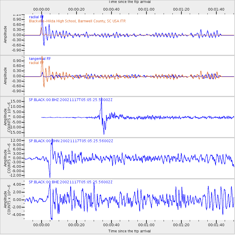
Signal To Noise
| Channel | StoN | STA | LTA |
| SP:BLACK:00:BHN:20021117T05:05:25.56002Z | 9.40581 | 3.515615E-6 | 3.7377058E-7 |
| SP:BLACK:00:BHE:20021117T05:05:25.56002Z | 3.5882382 | 1.4108956E-6 | 3.932001E-7 |
| SP:BLACK:00:BHZ:20021117T05:05:25.56002Z | 34.39205 | 5.3358885E-6 | 1.5514888E-7 |
| Arrivals |
| Ps | 4.3 SECOND |
| PpPs | 14 SECOND |
| PsPs/PpSs | 18 SECOND |


