You are here: Home > Network List > XN00 - RPI-UW Parkfield Calibration Array Stations List
> Station PAKD XN.PAKD > Earthquake Result Viewer
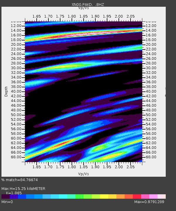
PAKD XN.PAKD - Earthquake Result Viewer
| Earthquake location: |
Chile-Bolivia Border Region |
| Earthquake latitude/longitude: |
-21.7/-68.3 |
| Earthquake time(UTC): |
2002/03/28 (087) 04:56:22 GMT |
| Earthquake Depth: |
125 km |
| Earthquake Magnitude: |
6.1 MB, 6.5 MW, 6.5 MW |
| Earthquake Catalog/Contributor: |
WHDF/NEIC |
|
| Network: |
XN RPI-UW Parkfield Calibration Array |
| Station: |
PAKD XN.PAKD |
| Lat/Lon: |
35.98 N/120.56 W |
| Elevation: |
695 m |
|
| Distance: |
75.7 deg |
| Az: |
318.568 deg |
| Baz: |
130.63 deg |
| Ray Param: |
0.051201995 |
| Estimated Moho Depth: |
15.25 km |
| Estimated Crust Vp/Vs: |
1.87 |
| Assumed Crust Vp: |
6.183 km/s |
| Estimated Crust Vs: |
3.315 km/s |
| Estimated Crust Poisson's Ratio: |
0.30 |
|
| Radial Match: |
84.76674 % |
| Radial Bump: |
400 |
| Transverse Match: |
78.76137 % |
| Transverse Bump: |
400 |
| SOD ConfigId: |
16820 |
| Insert Time: |
2010-03-08 23:23:20.534 +0000 |
| GWidth: |
2.5 |
| Max Bumps: |
400 |
| Tol: |
0.001 |
|

Signal To Noise
| Channel | StoN | STA | LTA |
| XN:PAKD: :BHZ:20020328T05:07:22.998022Z | 4.149834 | 2.06017E-6 | 4.964463E-7 |
| XN:PAKD: :BHN:20020328T05:07:22.998022Z | 1.7966596 | 1.3507731E-6 | 7.518247E-7 |
| XN:PAKD: :BHE:20020328T05:07:22.998022Z | 8.977565 | 4.9353766E-6 | 5.4974555E-7 |
| Arrivals |
| Ps | 2.2 SECOND |
| PpPs | 6.9 SECOND |
| PsPs/PpSs | 9.1 SECOND |


