
Station XN PAKD - XN.PAKD
Network: XN00 - RPI-UW Parkfield Calibration Array
Nearby stations (2 deg radius)
| Station | Name | (Lat, Lon) | Start / End | Elevation |
| PAKD | XN.PAKD | (35.98, -120.56) | 2001-06-24 / 2002-10-15 | 695 m |
| Crust2 Type: | S1,continental slope, margin, transition 1 km seds. |
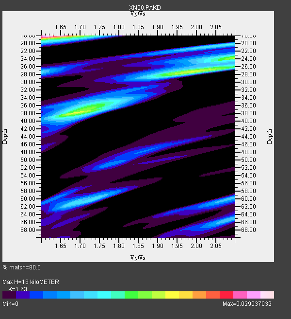
| Thickness Estimate: | 18 km |
| Thickness StdDev: | 9.0 km |
| Vp/Vs Estimate: | 1.63 |
| Vp/Vs StdDev: | 0.14 |
| Vs Estimate: | 3.793 km/s |
| Poisson's Ratio: | 0.20 |
| Peak Value: | 0.03 |
| Assumed Vp: | 6.183 km/s |
| Ps Weight: | 0.33333334 |
| PpPs Weight: | 0.33333334 |
| PsPs Weight: | 0.33333328 |
| Residual Complexity: | 0.902 |
| Nearby stations H: | 22 km +- 6.1 km |
| (2.0 deg) Vp/Vs: | 1.64 +- 0.05 |
0 with match > 90% ( 0.0 %) and 10 with match > 80% ( 40.0 %) out of 25.
Download stack as xyz text file.
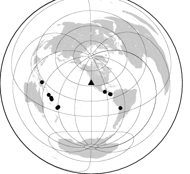
Azimuth Distribution of Events:
Prior Results for this Station
| Study | Thickness | Vp/Vs | Vp | Vs | Poissons Ratio | Extra |
| EARS | 18 km | 1.63 | 6.183 km/s | 3.793 km/s | 0.20 | |
| Crust2.0 | 23 km | 1.81 | 6.183 km/s | 3.422 km/s | 0.28 | S1,continental slope, margin, transition 1 km seds. |
| Global Maxima | 18 km | 1.63 | 6.183 km/s | 3.793 km/s | 0.20 | amp=0.029037032 |
| Local Maxima 1 | 38 km | 1.70 | 6.183 km/s | 3.631 km/s | 0.24 | amp=0.018334998 |
| Local Maxima 2 | 27 km | 1.99 | 6.183 km/s | 3.111 km/s | 0.33 | amp=0.016973317 |
| Local Maxima 3 | 24 km | 2.10 | 6.183 km/s | 2.948 km/s | 0.35 | amp=0.012890506 |
| Local Maxima 4 | 20 km | 2.08 | 6.183 km/s | 2.969 km/s | 0.35 | amp=0.0101535 |
| Predicted Arrivals for vertical incidence (zero ray parameter) | |
| Ps | 1.83 SECOND |
| PpPs | 7.66 SECOND |
| PsPs/PpSs | 9.49 SECOND |
Events Processed for this Station
Download zip of receiver functions as SAC
Plot maxima for each earthquake.
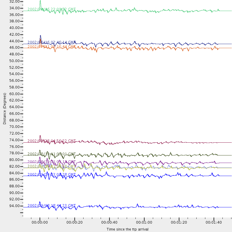
Events Used in the Stack
(10 events)| Radial Match | Distance | Baz | FERegion | Time | Lat/Lon | Depth | Magnitude |
| 89.61998 | 80.0 deg | 234.009 deg | Fiji Islands Region | 2002/08/19 11:01:01 GMT | (-21.7, -179.5) | 580 km | 6.7 MB, 7.6 MW, 7.7 ME |
| 87.59037 | 42.9 deg | 120.095 deg | Costa Rica | 2002/06/16 02:46:14 GMT | (8.8, -84.0) | 35 km | 5.4 MB, 6.2 MS, 6.4 MW, 6.4 MW |
| 87.22109 | 97.2 deg | 271.134 deg | Near N Coast Of New Guinea, P.N.G. | 2002/09/08 18:44:23 GMT | (-3.3, 142.9) | 13 km | 6.5 MB, 7.8 MS, 7.6 MW, 7.3 MW |
| 86.99078 | 84.2 deg | 247.679 deg | Vanuatu Islands | 2002/04/11 21:56:56 GMT | (-14.4, 167.7) | 10 km | 5.9 MB, 6.2 MS, 6.2 MW, 6.1 MW |
| 85.086464 | 31.9 deg | 122.701 deg | Near Coast Of Chiapas, Mexico | 2002/01/16 23:09:52 GMT | (15.5, -93.1) | 80 km | 5.8 MB, 6.4 MW, 6.4 MW |
| 84.76674 | 75.7 deg | 130.63 deg | Chile-Bolivia Border Region | 2002/03/28 04:56:22 GMT | (-21.7, -68.3) | 125 km | 6.1 MB, 6.5 MW, 6.5 MW |
| 84.674446 | 44.3 deg | 119.759 deg | South Of Panama | 2002/07/31 00:16:44 GMT | (7.9, -82.8) | 10 km | 6.0 MB, 6.4 MS, 6.5 MW, 6.4 MW |
| 82.01413 | 82.6 deg | 233.952 deg | South Of Fiji Islands | 2002/08/19 11:03:13 GMT | (-23.6, 178.5) | 650 km | 5.9 MB |
| 81.15061 | 86.8 deg | 254.536 deg | Solomon Islands | 2002/09/24 23:01:28 GMT | (-10.6, 161.2) | 19 km | 5.7 MB, 6.5 MS, 6.3 MW, 6.3 MW |
| 80.57127 | 84.0 deg | 249.88 deg | Santa Cruz Islands | 2002/06/17 21:26:22 GMT | (-12.6, 166.4) | 33 km | 6.0 MB, 6.7 MS, 6.7 MW, 6.6 MW |
Losers
(15 events)| Radial Match | Distance | Baz | FERegion | Time | Lat/Lon | Depth | Magnitude | Reason |
| 99.999985 | 82.0 deg | 134.447 deg | Catamarca Province, Argentina | 2002/05/28 04:04:22 GMT | (-28.9, -66.8) | 22 km | 6.0 MB, 5.7 MS, 6.0 MW, 5.9 MW | |
| 77.61611 | 81.0 deg | 138.568 deg | Near Coast Of Central Chile | 2002/06/18 13:56:22 GMT | (-30.8, -71.1) | 54 km | 6.0 MB, 6.6 MW, 6.4 MW | |
| 76.54509 | 76.7 deg | 236.202 deg | Fiji Islands Region | 2002/06/16 06:55:13 GMT | (-17.9, -178.7) | 569 km | 5.7 MB, 5.9 MW, 5.9 MW | |
| 76.01766 | 42.9 deg | 157.429 deg | Central East Pacific Rise | 2002/06/17 13:25:56 GMT | (-4.7, -105.4) | 10 km | 5.6 MS, 5.2 MB, 6.1 MW | |
| 72.23848 | 81.0 deg | 299.573 deg | Southeast Of Honshu, Japan | 2002/08/02 23:11:39 GMT | (29.3, 139.0) | 426 km | 5.5 MB, 6.3 MW, 6.3 MW | |
| 70.227844 | 82.9 deg | 233.821 deg | South Of Fiji Islands | 2002/08/19 11:23:06 GMT | (-23.9, 178.4) | 677 km | 6.1 MB | |
| 69.29583 | 81.1 deg | 234.469 deg | South Of Fiji Islands | 2002/06/30 21:29:36 GMT | (-22.2, 179.2) | 620 km | 5.5 MB, 6.5 MW, 6.4 MW | |
| 65.56081 | 80.1 deg | 233.824 deg | Fiji Islands Region | 2002/08/19 11:45:29 GMT | (-21.9, -179.4) | 600 km | 5.5 MB | |
| 64.76478 | 76.8 deg | 236.208 deg | Fiji Islands Region | 2002/05/04 07:00:48 GMT | (-17.9, -178.7) | 560 km | 5.3 MB, 5.8 MW, 5.7 MW | |
| 64.32065 | 77.4 deg | 316.59 deg | Northeastern China | 2002/09/15 08:39:32 GMT | (44.8, 129.9) | 586 km | 5.8 MB, 6.4 MW, 6.4 MW | |
| 63.51432 | 73.9 deg | 235.549 deg | Fiji Islands Region | 2002/08/09 13:31:05 GMT | (-16.3, -176.2) | 364 km | 5.5 MB, 6.1 MW, 6.1 MW | |
| 63.27701 | 86.8 deg | 254.633 deg | Solomon Islands | 2002/09/24 04:13:11 GMT | (-10.5, 161.2) | 10 km | 5.5 MB, 6.2 MS, 6.0 MW, 5.9 MW | |
| 60.90696 | 61.8 deg | 311.157 deg | Kuril Islands | 2002/07/17 02:20:33 GMT | (48.5, 153.3) | 148 km | 5.3 MB, 5.6 MW, 5.6 MW | |
| 58.3926 | 82.6 deg | 137.729 deg | San Juan Province, Argentina | 2002/09/24 03:57:22 GMT | (-31.5, -69.2) | 120 km | 6.2 MB, 6.4 MW, 6.3 MW | |
| 49.788456 | 72.9 deg | 236.194 deg | Tonga Islands | 2002/06/21 14:21:44 GMT | (-15.1, -175.9) | 319 km | 5.7 MB, 5.7 MW, 5.7 MW |
