You are here: Home > Network List > XN00 - RPI-UW Parkfield Calibration Array Stations List
> Station PAKD XN.PAKD > Earthquake Result Viewer
PAKD XN.PAKD - Earthquake Result Viewer
| Earthquake location: |
Fiji Islands Region |
| Earthquake latitude/longitude: |
-21.7/-179.5 |
| Earthquake time(UTC): |
2002/08/19 (231) 11:01:01 GMT |
| Earthquake Depth: |
580 km |
| Earthquake Magnitude: |
6.7 MB, 7.6 MW, 7.7 ME |
| Earthquake Catalog/Contributor: |
WHDF/NEIC |
|
| Network: |
XN RPI-UW Parkfield Calibration Array |
| Station: |
PAKD XN.PAKD |
| Lat/Lon: |
35.98 N/120.56 W |
| Elevation: |
695 m |
|
| Distance: |
80.0 deg |
| Az: |
44.881 deg |
| Baz: |
234.009 deg |
| Ray Param: |
0.046813875 |
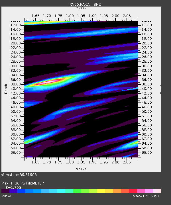
| Estimated Moho Depth: |
36.75 km |
| Estimated Crust Vp/Vs: |
1.71 |
| Assumed Crust Vp: |
6.183 km/s |
| Estimated Crust Vs: |
3.626 km/s |
| Estimated Crust Poisson's Ratio: |
0.24 |
|
| Radial Match: |
89.61998 % |
| Radial Bump: |
400 |
| Transverse Match: |
84.78639 % |
| Transverse Bump: |
400 |
| SOD ConfigId: |
16844 |
| Insert Time: |
2010-03-08 23:23:28.010 +0000 |
| GWidth: |
2.5 |
| Max Bumps: |
400 |
| Tol: |
0.001 |
|

Signal To Noise
| Channel | StoN | STA | LTA |
| XN:PAKD: :BHZ:20020819T11:11:39.723997Z | 24.768414 | 7.340666E-6 | 2.9637206E-7 |
| XN:PAKD: :BHN:20020819T11:11:39.723997Z | 2.6286976 | 1.5340224E-6 | 5.835675E-7 |
| XN:PAKD: :BHE:20020819T11:11:39.723997Z | 3.6785634 | 2.1055673E-6 | 5.723885E-7 |
| Arrivals |
| Ps | 4.3 SECOND |
| PpPs | 16 SECOND |
| PsPs/PpSs | 20 SECOND |


