You are here: Home > Network List > SP - South Carolina Earth Physics Project Stations List
> Station BLACK Blackville-Hilda High School, Barnwell County, SC USA > Earthquake Result Viewer
BLACK Blackville-Hilda High School, Barnwell County, SC USA - Earthquake Result Viewer
| Earthquake location: |
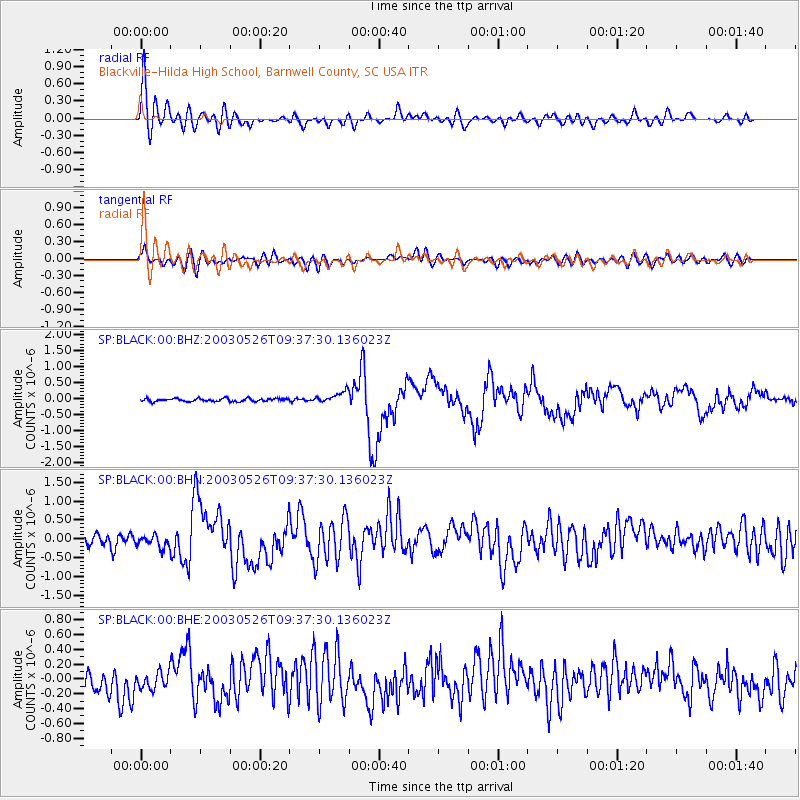
Near East Coast Of Honshu, Japan |
| Earthquake latitude/longitude: |
38.8/141.6 |
| Earthquake time(UTC): |
2003/05/26 (146) 09:24:33 GMT |
| Earthquake Depth: |
68 km |
| Earthquake Magnitude: |
6.7 MB, 7.0 MW, 7.0 MW |
| Earthquake Catalog/Contributor: |
WHDF/NEIC |
|
| Network: |
SP South Carolina Earth Physics Project |
| Station: |
BLACK Blackville-Hilda High School, Barnwell County, SC USA |
| Lat/Lon: |
33.36 N/81.26 W |
| Elevation: |
94 m |
|
| Distance: |
97.9 deg |
| Az: |
35.057 deg |
| Baz: |
327.593 deg |
| Ray Param: |
0.040024303 |
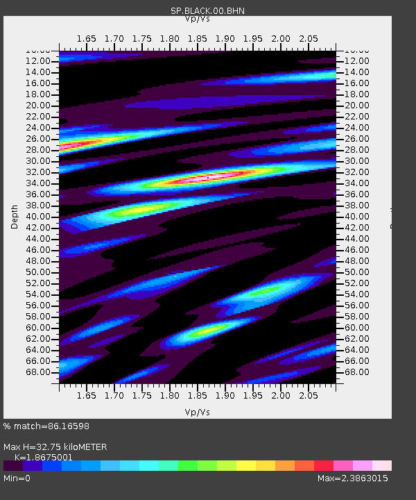
| Estimated Moho Depth: |
32.75 km |
| Estimated Crust Vp/Vs: |
1.87 |
| Assumed Crust Vp: |
6.565 km/s |
| Estimated Crust Vs: |
3.515 km/s |
| Estimated Crust Poisson's Ratio: |
0.30 |
|
| Radial Match: |
86.16598 % |
| Radial Bump: |
400 |
| Transverse Match: |
77.72509 % |
| Transverse Bump: |
400 |
| SOD ConfigId: |
2217 |
| Insert Time: |
2010-02-25 16:35:49.573 +0000 |
| GWidth: |
2.5 |
| Max Bumps: |
400 |
| Tol: |
0.001 |
|
Signal To Noise
| Channel | StoN | STA | LTA |
| SP:BLACK:00:BHN:20030526T09:37:30.136023Z | 0.78017724 | 1.658027E-7 | 2.1251928E-7 |
| SP:BLACK:00:BHE:20030526T09:37:30.136023Z | 0.8368786 | 1.13551025E-7 | 1.3568399E-7 |
| SP:BLACK:00:BHZ:20030526T09:37:30.136023Z | 3.8296506 | 1.7832498E-7 | 4.6564296E-8 |
| Arrivals |
| Ps | 4.4 SECOND |
| PpPs | 14 SECOND |
| PsPs/PpSs | 18 SECOND |


