You are here: Home > Network List > XN00 - RPI-UW Parkfield Calibration Array Stations List
> Station RCKY XN.RCKY > Earthquake Result Viewer
RCKY XN.RCKY - Earthquake Result Viewer
| Earthquake location: |
Chile-Bolivia Border Region |
| Earthquake latitude/longitude: |
-21.7/-68.3 |
| Earthquake time(UTC): |
2002/03/28 (087) 04:56:22 GMT |
| Earthquake Depth: |
125 km |
| Earthquake Magnitude: |
6.1 MB, 6.5 MW, 6.5 MW |
| Earthquake Catalog/Contributor: |
WHDF/NEIC |
|
| Network: |
XN RPI-UW Parkfield Calibration Array |
| Station: |
RCKY XN.RCKY |
| Lat/Lon: |
35.96 N/120.61 W |
| Elevation: |
703 m |
|
| Distance: |
75.7 deg |
| Az: |
318.528 deg |
| Baz: |
130.594 deg |
| Ray Param: |
0.05119304 |
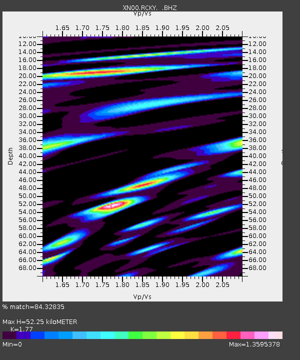
| Estimated Moho Depth: |
52.25 km |
| Estimated Crust Vp/Vs: |
1.77 |
| Assumed Crust Vp: |
6.183 km/s |
| Estimated Crust Vs: |
3.493 km/s |
| Estimated Crust Poisson's Ratio: |
0.27 |
|
| Radial Match: |
84.32835 % |
| Radial Bump: |
400 |
| Transverse Match: |
72.51048 % |
| Transverse Bump: |
400 |
| SOD ConfigId: |
16820 |
| Insert Time: |
2010-03-08 23:25:49.438 +0000 |
| GWidth: |
2.5 |
| Max Bumps: |
400 |
| Tol: |
0.001 |
|

Signal To Noise
| Channel | StoN | STA | LTA |
| XN:RCKY: :BHZ:20020328T05:07:23.074011Z | 4.0935564 | 1.0385121E-6 | 2.5369434E-7 |
| XN:RCKY: :BHN:20020328T05:07:23.074011Z | 2.5240073 | 1.1126689E-6 | 4.408342E-7 |
| XN:RCKY: :BHE:20020328T05:07:23.074011Z | 14.686381 | 4.026441E-6 | 2.7416152E-7 |
| Arrivals |
| Ps | 6.7 SECOND |
| PpPs | 23 SECOND |
| PsPs/PpSs | 29 SECOND |


