
Station XN RCKY - XN.RCKY
Network: XN00 - RPI-UW Parkfield Calibration Array
Nearby stations (2 deg radius)
| Station | Name | (Lat, Lon) | Start / End | Elevation |
| RCKY | XN.RCKY | (35.96, -120.61) | 2001-06-24 / 2002-10-15 | 703 m |
| Crust2 Type: | S1,continental slope, margin, transition 1 km seds. |
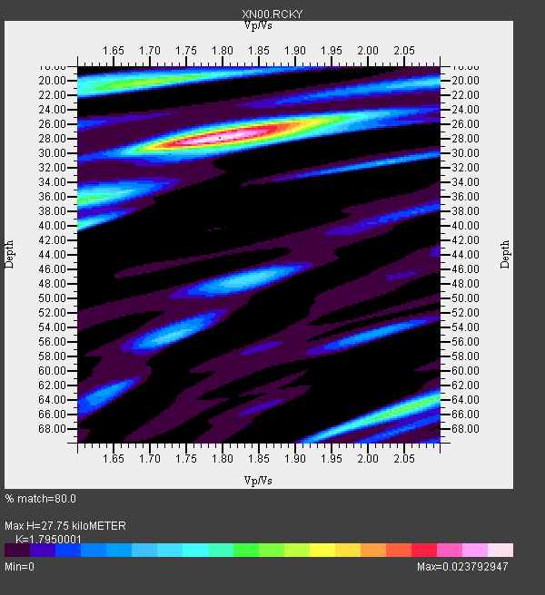
| Thickness Estimate: | 28 km |
| Thickness StdDev: | 13 km |
| Vp/Vs Estimate: | 1.80 |
| Vp/Vs StdDev: | 0.10 |
| Vs Estimate: | 3.444 km/s |
| Poisson's Ratio: | 0.27 |
| Peak Value: | 0.02 |
| Assumed Vp: | 6.183 km/s |
| Ps Weight: | 0.33333334 |
| PpPs Weight: | 0.33333334 |
| PsPs Weight: | 0.33333328 |
| Residual Complexity: | 0.616 |
| Nearby stations H: | 27 km +- 1.4 km |
| (2.0 deg) Vp/Vs: | 1.77 +- 0.04 |
2 with match > 90% ( 6.25 %) and 11 with match > 80% ( 34.375 %) out of 32.
Download stack as xyz text file.
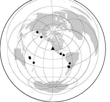
Azimuth Distribution of Events:
Prior Results for this Station
| Study | Thickness | Vp/Vs | Vp | Vs | Poissons Ratio | Extra |
| EARS | 28 km | 1.80 | 6.183 km/s | 3.444 km/s | 0.27 | |
| Crust2.0 | 23 km | 1.81 | 6.183 km/s | 3.422 km/s | 0.28 | S1,continental slope, margin, transition 1 km seds. |
| Global Maxima | 28 km | 1.80 | 6.183 km/s | 3.444 km/s | 0.27 | amp=0.023792947 |
| Local Maxima 1 | 20 km | 1.71 | 6.183 km/s | 3.621 km/s | 0.24 | amp=0.013371388 |
| Local Maxima 2 | 65 km | 2.06 | 6.183 km/s | 3.001 km/s | 0.35 | amp=0.01301082 |
| Local Maxima 3 | 36 km | 1.62 | 6.183 km/s | 3.816 km/s | 0.19 | amp=0.011463557 |
| Local Maxima 4 | 26 km | 1.88 | 6.183 km/s | 3.28 km/s | 0.30 | amp=0.011249848 |
| Predicted Arrivals for vertical incidence (zero ray parameter) | |
| Ps | 3.57 SECOND |
| PpPs | 12.55 SECOND |
| PsPs/PpSs | 16.11 SECOND |
Events Processed for this Station
Download zip of receiver functions as SAC
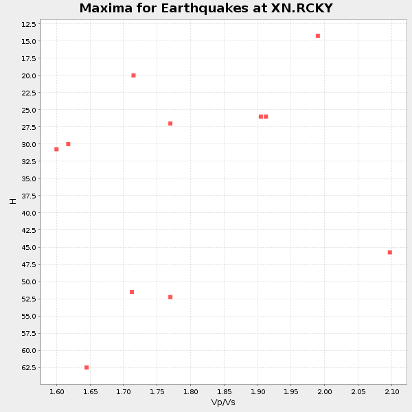
Plot maxima for each earthquake.
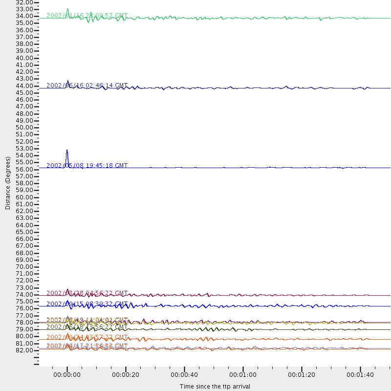
Events Used in the Stack
(11 events)| Radial Match | Distance | Baz | FERegion | Time | Lat/Lon | Depth | Magnitude |
| 93.82937 | 55.6 deg | 315.171 deg | Near East Coast Of Kamchatka | 2002/05/08 19:45:18 GMT | (53.8, 160.8) | 39 km | 5.8 MB, 5.4 MS, 5.9 MW, 5.8 MW |
| 90.781685 | 77.4 deg | 316.573 deg | Northeastern China | 2002/09/15 08:39:32 GMT | (44.8, 129.9) | 586 km | 5.8 MB, 6.4 MW, 6.4 MW |
| 89.20855 | 84.1 deg | 247.654 deg | Vanuatu Islands | 2002/04/11 21:56:56 GMT | (-14.4, 167.7) | 10 km | 5.9 MB, 6.2 MS, 6.2 MW, 6.1 MW |
| 88.705734 | 80.0 deg | 137.998 deg | Near Coast Of Central Chile | 2002/04/01 19:59:32 GMT | (-29.7, -71.4) | 71 km | 6.1 MB, 6.4 MW, 6.4 MW |
| 88.1234 | 42.9 deg | 120.031 deg | Costa Rica | 2002/06/16 02:46:14 GMT | (8.8, -84.0) | 35 km | 5.4 MB, 6.2 MS, 6.4 MW, 6.4 MW |
| 87.19523 | 82.6 deg | 137.699 deg | San Juan Province, Argentina | 2002/09/24 03:57:22 GMT | (-31.5, -69.2) | 120 km | 6.2 MB, 6.4 MW, 6.3 MW |
| 86.705574 | 79.9 deg | 233.983 deg | Fiji Islands Region | 2002/08/19 11:01:01 GMT | (-21.7, -179.5) | 580 km | 6.7 MB, 7.6 MW, 7.7 ME |
| 85.06445 | 81.0 deg | 138.536 deg | Near Coast Of Central Chile | 2002/06/18 13:56:22 GMT | (-30.8, -71.1) | 54 km | 6.0 MB, 6.6 MW, 6.4 MW |
| 84.32835 | 75.7 deg | 130.594 deg | Chile-Bolivia Border Region | 2002/03/28 04:56:22 GMT | (-21.7, -68.3) | 125 km | 6.1 MB, 6.5 MW, 6.5 MW |
| 84.23093 | 31.9 deg | 122.617 deg | Near Coast Of Chiapas, Mexico | 2002/01/16 23:09:52 GMT | (15.5, -93.1) | 80 km | 5.8 MB, 6.4 MW, 6.4 MW |
| 83.02506 | 84.0 deg | 249.855 deg | Santa Cruz Islands | 2002/06/17 21:26:22 GMT | (-12.6, 166.4) | 33 km | 6.0 MB, 6.7 MS, 6.7 MW, 6.6 MW |
Losers
(21 events)| Radial Match | Distance | Baz | FERegion | Time | Lat/Lon | Depth | Magnitude | Reason |
| 80.14981 | 82.0 deg | 134.416 deg | Catamarca Province, Argentina | 2002/05/28 04:04:22 GMT | (-28.9, -66.8) | 22 km | 6.0 MB, 5.7 MS, 6.0 MW, 5.9 MW | |
| 78.47021 | 86.8 deg | 254.511 deg | Solomon Islands | 2002/09/24 23:01:28 GMT | (-10.6, 161.2) | 19 km | 5.7 MB, 6.5 MS, 6.3 MW, 6.3 MW | |
| 77.92219 | 82.5 deg | 233.926 deg | South Of Fiji Islands | 2002/08/19 11:03:13 GMT | (-23.6, 178.5) | 650 km | 5.9 MB | |
| 75.98444 | 81.0 deg | 299.553 deg | Southeast Of Honshu, Japan | 2002/08/02 23:11:39 GMT | (29.3, 139.0) | 426 km | 5.5 MB, 6.3 MW, 6.3 MW | |
| 71.33953 | 47.1 deg | 126.261 deg | Off Coast Of Central America | 2002/08/31 05:27:18 GMT | (2.7, -84.4) | 23 km | 5.7 MB, 5.1 MS, 5.6 MW, 5.5 MW | |
| 66.65863 | 81.1 deg | 234.443 deg | South Of Fiji Islands | 2002/06/30 21:29:36 GMT | (-22.2, 179.2) | 620 km | 5.5 MB, 6.5 MW, 6.4 MW | |
| 66.11567 | 86.4 deg | 242.899 deg | Vanuatu Islands | 2002/08/12 02:59:24 GMT | (-19.5, 169.0) | 112 km | 5.6 MB, 6.0 MW, 5.9 MW | |
| 65.830505 | 76.7 deg | 236.176 deg | Fiji Islands Region | 2002/06/16 06:55:13 GMT | (-17.9, -178.7) | 569 km | 5.7 MB, 5.9 MW, 5.9 MW | |
| 65.175385 | 78.2 deg | 231.872 deg | Fiji Islands Region | 2002/08/07 04:50:06 GMT | (-21.9, -176.6) | 174 km | 5.4 MB, 5.8 MW, 5.7 MW | |
| 63.182655 | 76.7 deg | 236.182 deg | Fiji Islands Region | 2002/05/04 07:00:48 GMT | (-17.9, -178.7) | 560 km | 5.3 MB, 5.8 MW, 5.7 MW | |
| 63.146152 | 72.8 deg | 236.168 deg | Tonga Islands | 2002/06/21 14:21:44 GMT | (-15.1, -175.9) | 319 km | 5.7 MB, 5.7 MW, 5.7 MW | |
| 60.281513 | 97.4 deg | 271.253 deg | Near N Coast Of New Guinea, P.N.G. | 2002/09/16 13:23:00 GMT | (-3.3, 142.7) | 10 km | 5.9 MB, 5.9 MS, 6.3 MW, 6.1 MW | |
| 57.31587 | 81.1 deg | 138.588 deg | Near Coast Of Central Chile | 2002/06/23 11:10:42 GMT | (-30.8, -71.2) | 67 km | 5.6 MB, 5.5 MW, 5.4 MW | |
| 56.91619 | 85.7 deg | 243.352 deg | Vanuatu Islands | 2002/10/07 19:00:31 GMT | (-18.7, 169.3) | 246 km | 5.4 MB, 5.7 MW, 5.6 MW | |
| 56.373714 | 66.1 deg | 308.469 deg | Kuril Islands | 2002/08/30 05:58:21 GMT | (44.5, 149.1) | 31 km | 5.7 MB, 5.5 MW, 5.3 MW | |
| 55.33193 | 74.2 deg | 304.656 deg | Off East Coast Of Honshu, Japan | 2002/07/23 20:05:31 GMT | (37.3, 142.2) | 33 km | 5.7 MB, 5.2 MS, 5.6 MW, 5.6 MW | |
| 55.212826 | 86.7 deg | 254.608 deg | Solomon Islands | 2002/09/24 04:13:11 GMT | (-10.5, 161.2) | 10 km | 5.5 MB, 6.2 MS, 6.0 MW, 5.9 MW | |
| 55.135864 | 80.0 deg | 233.797 deg | Fiji Islands Region | 2002/08/19 11:45:29 GMT | (-21.9, -179.4) | 600 km | 5.5 MB | |
| 51.528614 | 86.8 deg | 254.215 deg | Solomon Islands | 2002/09/28 13:53:16 GMT | (-10.9, 161.4) | 10 km | 5.5 MS, 5.2 MB, 5.7 MW, 5.6 MW | |
| 47.474575 | 82.1 deg | 139.15 deg | Chile-Argentina Border Region | 2002/05/24 00:23:15 GMT | (-32.0, -70.9) | 60 km | 5.3 MB, 5.7 MW, 5.6 MW | |
| 42.802273 | 60.9 deg | 130.964 deg | Near Coast Of Peru | 2002/05/11 10:43:07 GMT | (-10.4, -78.5) | 47 km | 5.5 MB, 5.0 MS, 5.7 MW, 5.7 MW |
