You are here: Home > Network List > SP - South Carolina Earth Physics Project Stations List
> Station BLACK Blackville-Hilda High School, Barnwell County, SC USA > Earthquake Result Viewer
BLACK Blackville-Hilda High School, Barnwell County, SC USA - Earthquake Result Viewer

| Earthquake location: |
Western Brazil |
| Earthquake latitude/longitude: |
-7.6/-71.7 |
| Earthquake time(UTC): |
2003/06/20 (171) 06:19:38 GMT |
| Earthquake Depth: |
558 km |
| Earthquake Magnitude: |
6.4 MB, 7.1 MW, 7.0 MW |
| Earthquake Catalog/Contributor: |
WHDF/NEIC |
|
| Network: |
SP South Carolina Earth Physics Project |
| Station: |
BLACK Blackville-Hilda High School, Barnwell County, SC USA |
| Lat/Lon: |
33.36 N/81.26 W |
| Elevation: |
94 m |
|
| Distance: |
41.7 deg |
| Az: |
347.973 deg |
| Baz: |
165.711 deg |
| Ray Param: |
0.07080085 |
| Estimated Moho Depth: |
31.75 km |
| Estimated Crust Vp/Vs: |
1.87 |
| Assumed Crust Vp: |
6.565 km/s |
| Estimated Crust Vs: |
3.506 km/s |
| Estimated Crust Poisson's Ratio: |
0.30 |
|
| Radial Match: |
82.31803 % |
| Radial Bump: |
400 |
| Transverse Match: |
52.528164 % |
| Transverse Bump: |
400 |
| SOD ConfigId: |
2217 |
| Insert Time: |
2010-02-25 16:35:52.142 +0000 |
| GWidth: |
2.5 |
| Max Bumps: |
400 |
| Tol: |
0.001 |
|
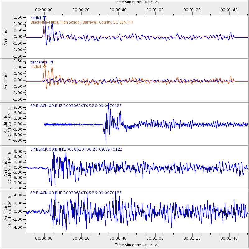
Signal To Noise
| Channel | StoN | STA | LTA |
| SP:BLACK:00:BHN:20030620T06:26:09.097012Z | 13.600836 | 3.2952687E-6 | 2.4228427E-7 |
| SP:BLACK:00:BHE:20030620T06:26:09.097012Z | 5.9978533 | 9.909646E-7 | 1.652199E-7 |
| SP:BLACK:00:BHZ:20030620T06:26:09.097012Z | 19.352081 | 3.3566473E-6 | 1.734515E-7 |
| Arrivals |
| Ps | 4.5 SECOND |
| PpPs | 13 SECOND |
| PsPs/PpSs | 18 SECOND |


