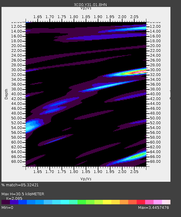
Y31 Y31 - Earthquake Result Viewer
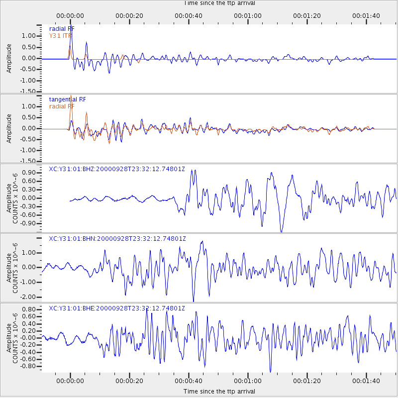
Earthquake location: Near Coast Of Ecuador
Earthquake latitude/longitude: -0.2/-80.6
Earthquake time(UTC): 2000/09/28 (272) 23:23:43 GMT
Earthquake Depth: 23 km
Earthquake Magnitude: 5.8 MB, 6.0 MS, 6.6 MW, 6.4 MW
Earthquake Catalog/Contributor: WHDF/NEIC
Network: XC Yellowstone Intermountain Seismic Array
Station: Y31 Y31
Lat/Lon: 43.74 N/109.98 W
Elevation: 2789 m
Distance: 51.0 deg
Az: 332.768 deg
Baz: 140.848 deg
Ray Param: 0.06763286
Estimated Moho Depth: 30.5 km
Estimated Crust Vp/Vs: 2.09
Assumed Crust Vp: 6.161 km/s
Estimated Crust Vs: 2.955 km/s
Estimated Crust Poisson's Ratio: 0.35
Radial Match: 85.32421 %
Radial Bump: 400
Transverse Match: 68.933784 %
Transverse Bump: 400
SOD ConfigId: 3744
Insert Time: 2010-02-26 15:00:21.551 +0000
GWidth: 2.5
Max Bumps: 400
Tol: 0.001

Signal To Noise

ChannelStoNSTALTA
XC:Y31:01:BHN:20000928T23:32:12.74801Z0.76809891.6556949E-72.155575E-7
XC:Y31:01:BHE:20000928T23:32:12.74801Z2.04290371.5078245E-77.380791E-8
XC:Y31:01:BHZ:20000928T23:32:12.74801Z0.740724154.2228425E-85.700965E-8
Arrivals
Ps5.6 SECOND
PpPs15 SECOND
PsPs/PpSs20 SECOND