
Station XC Y31 - Y31
Network: XC00 - Yellowstone Intermountain Seismic Array
Nearby stations (2 deg radius)
| Station | Name | (Lat, Lon) | Start / End | Elevation |
| Y31 | Y31 | (43.74, -109.98) | 2000-06-23 / 2001-12-31 | 2789 m |
| Crust2 Type: | Q0,orogen/46km no ice, Rockies, Tarim Basin, 4 km seds. |
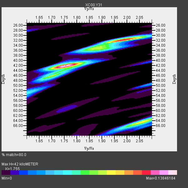
| Thickness Estimate: | 42 km |
| Thickness StdDev: | 5.2 km |
| Vp/Vs Estimate: | 1.75 |
| Vp/Vs StdDev: | 0.13 |
| Vs Estimate: | 3.51 km/s |
| Poisson's Ratio: | 0.26 |
| Peak Value: | 0.14 |
| Assumed Vp: | 6.161 km/s |
| Ps Weight: | 0.33333334 |
| PpPs Weight: | 0.33333334 |
| PsPs Weight: | 0.33333328 |
| Residual Complexity: | 0.670 |
| Nearby stations H: | +- |
| (2.0 deg) Vp/Vs: | +- |
0 with match > 90% ( 0.0 %) and 5 with match > 80% ( 100.0 %) out of 5.
Download stack as xyz text file.
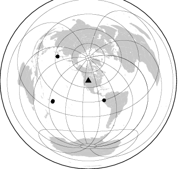
Azimuth Distribution of Events:
Prior Results for this Station
| Study | Thickness | Vp/Vs | Vp | Vs | Poissons Ratio | Extra |
| EARS | 42 km | 1.75 | 6.161 km/s | 3.51 km/s | 0.26 | |
| Crust2.0 | 46 km | 1.75 | 6.161 km/s | 3.511 km/s | 0.26 | Q0,orogen/46km no ice, Rockies, Tarim Basin, 4 km seds. |
| Global Maxima | 42 km | 1.75 | 6.161 km/s | 3.51 km/s | 0.26 | amp=0.13846184 |
| Local Maxima 1 | 32 km | 2.00 | 6.161 km/s | 3.088 km/s | 0.33 | amp=0.112363294 |
| Local Maxima 2 | 64 km | 2.06 | 6.161 km/s | 2.998 km/s | 0.34 | amp=0.09031293 |
| Local Maxima 3 | 46 km | 1.69 | 6.161 km/s | 3.651 km/s | 0.23 | amp=0.05166309 |
| Local Maxima 4 | 35 km | 1.86 | 6.161 km/s | 3.312 km/s | 0.30 | amp=0.0438076 |
| Predicted Arrivals for vertical incidence (zero ray parameter) | |
| Ps | 5.15 SECOND |
| PpPs | 18.78 SECOND |
| PsPs/PpSs | 23.93 SECOND |
Events Processed for this Station
Download zip of receiver functions as SAC
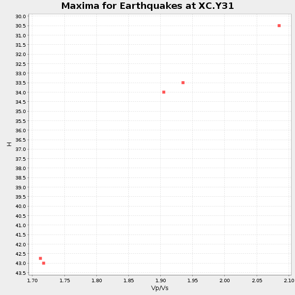
Plot maxima for each earthquake.
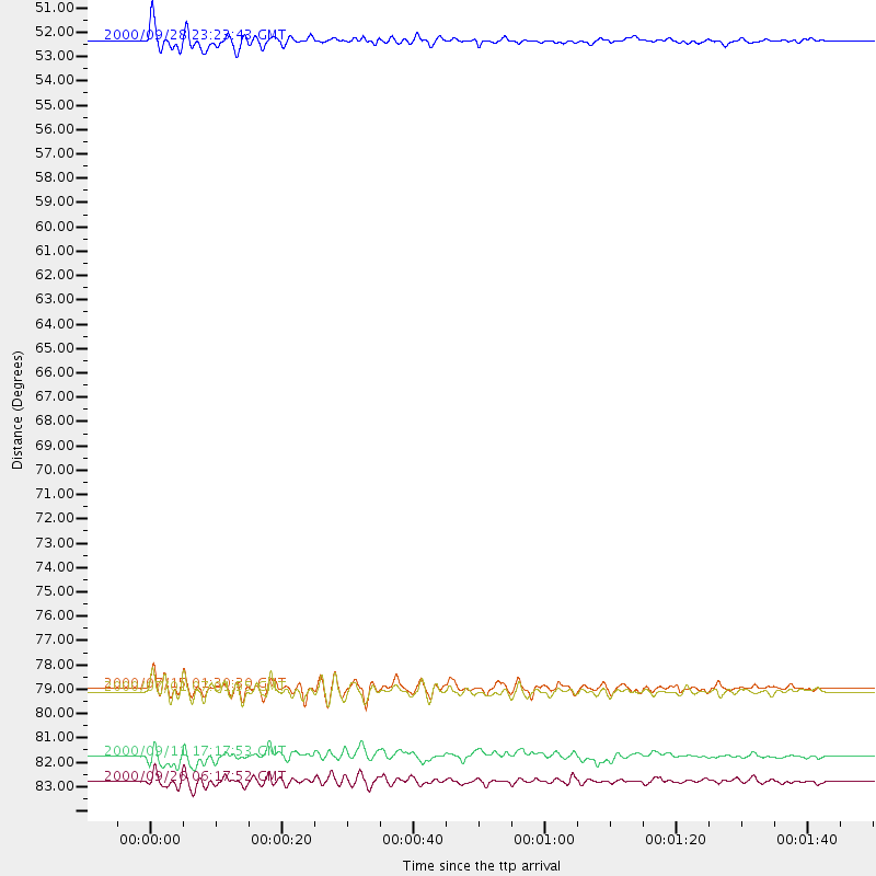
Events Used in the Stack
(5 events)| Radial Match | Distance | Baz | FERegion | Time | Lat/Lon | Depth | Magnitude |
| 89.71541 | 84.1 deg | 239.689 deg | Tonga Islands | 2000/09/26 06:17:52 GMT | (-17.2, -173.9) | 56 km | 6.1 MB, 6.1 MS, 6.4 MW, 6.1 ME |
| 86.79414 | 80.1 deg | 308.201 deg | Near S. Coast Of Honshu, Japan | 2000/07/01 07:01:55 GMT | (34.2, 139.1) | 10 km | 6.0 MB, 6.1 MS, 6.2 MW, 6.2 MW |
| 85.32421 | 51.0 deg | 140.848 deg | Near Coast Of Ecuador | 2000/09/28 23:23:43 GMT | (-0.2, -80.6) | 23 km | 5.8 MB, 6.0 MS, 6.6 MW, 6.4 MW |
| 83.05856 | 80.0 deg | 308.191 deg | Near S. Coast Of Honshu, Japan | 2000/07/15 01:30:30 GMT | (34.3, 139.3) | 10 km | 5.5 MB, 5.9 MS, 6.1 MW, 6.0 MW |
| 80.054306 | 83.0 deg | 240.368 deg | Tonga Islands | 2000/09/11 17:17:53 GMT | (-15.9, -173.7) | 115 km | 6.0 MB, 6.3 MW, 6.3 MW |
Losers
(0 events)| Radial Match | Distance | Baz | FERegion | Time | Lat/Lon | Depth | Magnitude | Reason |
