You are here: Home > Network List > XC00 - Yellowstone Intermountain Seismic Array Stations List
> Station Y31 Y31 > Earthquake Result Viewer
Y31 Y31 - Earthquake Result Viewer
| Earthquake location: |
Tonga Islands |
| Earthquake latitude/longitude: |
-15.9/-173.7 |
| Earthquake time(UTC): |
2000/09/11 (255) 17:17:53 GMT |
| Earthquake Depth: |
115 km |
| Earthquake Magnitude: |
6.0 MB, 6.3 MW, 6.3 MW |
| Earthquake Catalog/Contributor: |
WHDF/NEIC |
|
| Network: |
XC Yellowstone Intermountain Seismic Array |
| Station: |
Y31 Y31 |
| Lat/Lon: |
43.74 N/109.98 W |
| Elevation: |
2789 m |
|
| Distance: |
83.0 deg |
| Az: |
40.891 deg |
| Baz: |
240.368 deg |
| Ray Param: |
0.046229564 |
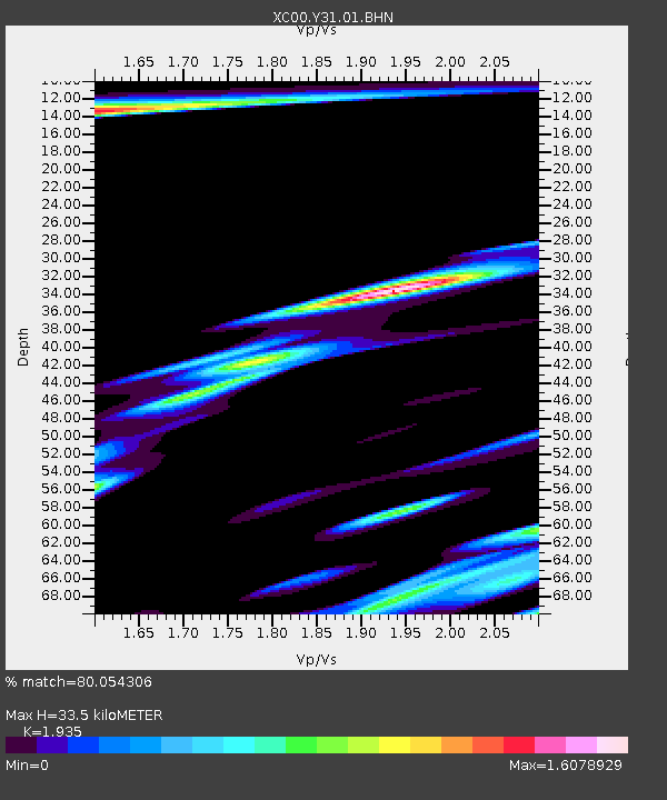
| Estimated Moho Depth: |
33.5 km |
| Estimated Crust Vp/Vs: |
1.93 |
| Assumed Crust Vp: |
6.161 km/s |
| Estimated Crust Vs: |
3.184 km/s |
| Estimated Crust Poisson's Ratio: |
0.32 |
|
| Radial Match: |
80.054306 % |
| Radial Bump: |
400 |
| Transverse Match: |
78.78239 % |
| Transverse Bump: |
400 |
| SOD ConfigId: |
16820 |
| Insert Time: |
2010-02-26 15:00:26.278 +0000 |
| GWidth: |
2.5 |
| Max Bumps: |
400 |
| Tol: |
0.001 |
|
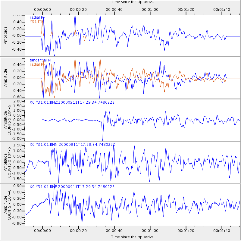
Signal To Noise
| Channel | StoN | STA | LTA |
| XC:Y31:01:BHN:20000911T17:29:34.748022Z | 0.8890963 | 3.5485476E-7 | 3.9911845E-7 |
| XC:Y31:01:BHE:20000911T17:29:34.748022Z | 2.7235405 | 3.6768634E-7 | 1.3500306E-7 |
| XC:Y31:01:BHZ:20000911T17:29:34.748022Z | 9.147949 | 6.8756486E-7 | 7.516054E-8 |
| Arrivals |
| Ps | 5.2 SECOND |
| PpPs | 16 SECOND |
| PsPs/PpSs | 21 SECOND |


