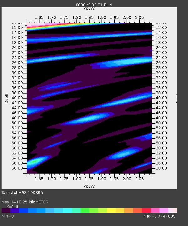
Y102 Y102 - Earthquake Result Viewer
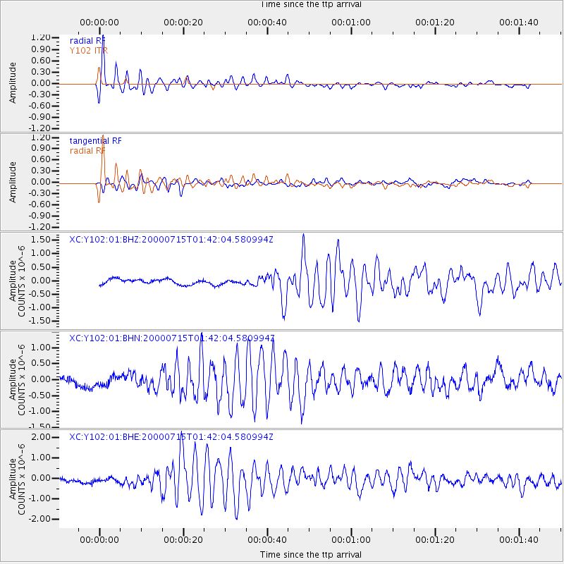
Earthquake location: Near S. Coast Of Honshu, Japan
Earthquake latitude/longitude: 34.3/139.3
Earthquake time(UTC): 2000/07/15 (197) 01:30:30 GMT
Earthquake Depth: 10 km
Earthquake Magnitude: 5.5 MB, 5.9 MS, 6.1 MW, 6.0 MW
Earthquake Catalog/Contributor: WHDF/NEIC
Network: XC Yellowstone Intermountain Seismic Array
Station: Y102 Y102
Lat/Lon: 44.32 N/110.60 W
Elevation: 2438 m
Distance: 79.3 deg
Az: 43.311 deg
Baz: 307.729 deg
Ray Param: 0.049076285
Estimated Moho Depth: 10.25 km
Estimated Crust Vp/Vs: 1.60
Assumed Crust Vp: 6.35 km/s
Estimated Crust Vs: 3.969 km/s
Estimated Crust Poisson's Ratio: 0.18
Radial Match: 93.100395 %
Radial Bump: 400
Transverse Match: 68.684944 %
Transverse Bump: 400
SOD ConfigId: 3744
Insert Time: 2010-02-26 15:00:33.438 +0000
GWidth: 2.5
Max Bumps: 400
Tol: 0.001

Signal To Noise

ChannelStoNSTALTA
XC:Y102:01:BHN:20000715T01:42:04.580994Z0.97518331.428285E-71.4646324E-7
XC:Y102:01:BHE:20000715T01:42:04.580994Z0.643261739.932745E-81.5441219E-7
XC:Y102:01:BHZ:20000715T01:42:04.580994Z0.72677856.8410756E-89.412875E-8
Arrivals
Ps1.0 SECOND
PpPs4.1 SECOND
PsPs/PpSs5.1 SECOND