
Station XC Y102 - Y102
Network: XC00 - Yellowstone Intermountain Seismic Array
Nearby stations (2 deg radius)
| Station | Name | (Lat, Lon) | Start / End | Elevation |
| Y102 | Y102 | (44.32, -110.60) | 2000-07-11 / 2001-12-31 | 2438 m |
| Crust2 Type: | P6,orogen/43km, Orogen, 0.5 km seds. |
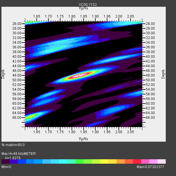
| Thickness Estimate: | 48 km |
| Thickness StdDev: | 8.7 km |
| Vp/Vs Estimate: | 1.83 |
| Vp/Vs StdDev: | 0.07 |
| Vs Estimate: | 3.475 km/s |
| Poisson's Ratio: | 0.29 |
| Peak Value: | 0.07 |
| Assumed Vp: | 6.35 km/s |
| Ps Weight: | 0.33333334 |
| PpPs Weight: | 0.33333334 |
| PsPs Weight: | 0.33333328 |
| Residual Complexity: | 0.694 |
| Nearby stations H: | +- |
| (2.0 deg) Vp/Vs: | +- |
3 with match > 90% ( 42.857143 %) and 7 with match > 80% ( 100.0 %) out of 7.
Download stack as xyz text file.
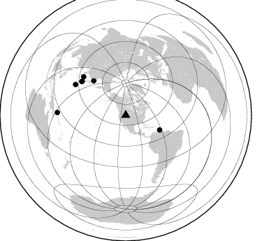
Azimuth Distribution of Events:
Prior Results for this Station
| Study | Thickness | Vp/Vs | Vp | Vs | Poissons Ratio | Extra |
| EARS | 48 km | 1.83 | 6.35 km/s | 3.475 km/s | 0.29 | |
| Crust2.0 | 43 km | 1.76 | 6.35 km/s | 3.609 km/s | 0.26 | P6,orogen/43km, Orogen, 0.5 km seds. |
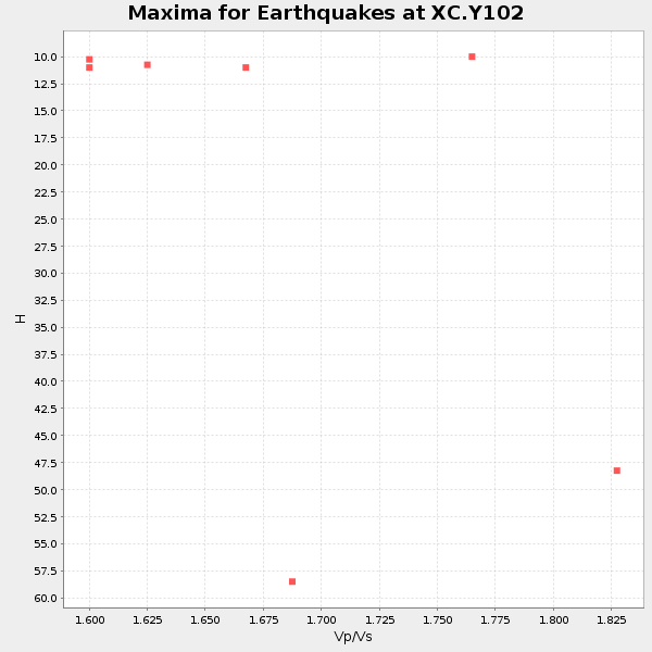
| Global Maxima | 48 km | 1.83 | 6.35 km/s | 3.475 km/s | 0.29 | amp=0.07302377 |
| Local Maxima 1 | 66 km | 1.62 | 6.35 km/s | 3.92 km/s | 0.19 | amp=0.041766964 |
| Local Maxima 2 | 25 km | 1.63 | 6.35 km/s | 3.884 km/s | 0.20 | amp=0.037098322 |
| Local Maxima 3 | 25 km | 2.09 | 6.35 km/s | 3.042 km/s | 0.35 | amp=0.033774205 |
| Local Maxima 4 | 36 km | 1.74 | 6.35 km/s | 3.66 km/s | 0.25 | amp=0.030133214 |
| Predicted Arrivals for vertical incidence (zero ray parameter) | |
| Ps | 6.26 SECOND |
| PpPs | 21.37 SECOND |
| PsPs/PpSs | 27.63 SECOND |
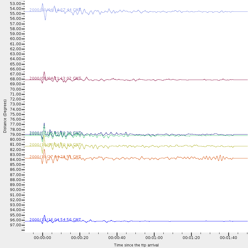
Events Processed for this Station
Download zip of receiver functions as SAC
Plot maxima for each earthquake.
Events Used in the Stack
(7 events)| Radial Match | Distance | Baz | FERegion | Time | Lat/Lon | Depth | Magnitude |
| 93.100395 | 79.3 deg | 307.729 deg | Near S. Coast Of Honshu, Japan | 2000/07/15 01:30:30 GMT | (34.3, 139.3) | 10 km | 5.5 MB, 5.9 MS, 6.1 MW, 6.0 MW |
| 92.76951 | 67.5 deg | 316.852 deg | Sakhalin, Russia | 2000/08/04 21:13:02 GMT | (48.8, 142.2) | 10 km | 6.3 MB, 7.1 MS, 6.8 MW, 6.7 MW |
| 92.52546 | 79.5 deg | 307.367 deg | Southeast Of Honshu, Japan | 2000/07/30 12:25:45 GMT | (33.9, 139.4) | 10 km | 6.0 MB, 6.5 MS, 6.5 MW, 6.5 MW |
| 88.51517 | 52.8 deg | 113.622 deg | Windward Islands | 2000/10/04 14:37:44 GMT | (11.1, -62.6) | 110 km | 5.6 MB, 5.4 MS, 6.1 MW, 5.9 MD |
| 88.14355 | 81.8 deg | 312.294 deg | Western Honshu, Japan | 2000/10/06 04:30:19 GMT | (35.5, 133.1) | 10 km | 5.8 MB, 6.8 MS, 7.0 ME, 6.7 MW |
| 86.68821 | 97.9 deg | 272.192 deg | New Ireland Region, P.N.G. | 2000/11/16 04:54:56 GMT | (-4.0, 152.2) | 33 km | 6.0 MB, 8.2 MS, 8.0 MW, 8.0 ME |
| 81.673615 | 84.4 deg | 301.419 deg | Bonin Islands, Japan Region | 2000/10/27 04:21:51 GMT | (26.3, 140.5) | 388 km | 6.1 MB, 6.1 MW, 6.0 MW |
Losers
(0 events)| Radial Match | Distance | Baz | FERegion | Time | Lat/Lon | Depth | Magnitude | Reason |
