You are here: Home > Network List > AK - Alaska Regional Network Stations List
> Station BAL Baldy Mountain > Earthquake Result Viewer
BAL Baldy Mountain - Earthquake Result Viewer
| Earthquake location: |
Vanuatu Islands |
| Earthquake latitude/longitude: |
-16.1/168.1 |
| Earthquake time(UTC): |
2020/08/05 (218) 12:05:36 GMT |
| Earthquake Depth: |
175 km |
| Earthquake Magnitude: |
6.4 mww |
| Earthquake Catalog/Contributor: |
NEIC PDE/us |
|
| Network: |
AK Alaska Regional Network |
| Station: |
BAL Baldy Mountain |
| Lat/Lon: |
61.04 N/142.34 W |
| Elevation: |
1341 m |
|
| Distance: |
86.4 deg |
| Az: |
21.793 deg |
| Baz: |
227.152 deg |
| Ray Param: |
0.043664142 |
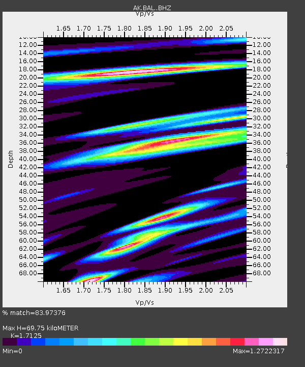
| Estimated Moho Depth: |
69.75 km |
| Estimated Crust Vp/Vs: |
1.71 |
| Assumed Crust Vp: |
6.566 km/s |
| Estimated Crust Vs: |
3.834 km/s |
| Estimated Crust Poisson's Ratio: |
0.24 |
|
| Radial Match: |
83.97376 % |
| Radial Bump: |
400 |
| Transverse Match: |
78.36877 % |
| Transverse Bump: |
400 |
| SOD ConfigId: |
21709731 |
| Insert Time: |
2020-08-19 12:06:47.557 +0000 |
| GWidth: |
2.5 |
| Max Bumps: |
400 |
| Tol: |
0.001 |
|

Signal To Noise
| Channel | StoN | STA | LTA |
| AK:BAL: :BHZ:20200805T12:17:27.687998Z | 8.254495 | 7.0391764E-7 | 8.527689E-8 |
| AK:BAL: :BHN:20200805T12:17:27.687998Z | 2.7503433 | 2.390757E-7 | 8.692576E-8 |
| AK:BAL: :BHE:20200805T12:17:27.687998Z | 2.5584612 | 2.5651994E-7 | 1.00263364E-7 |
| Arrivals |
| Ps | 7.8 SECOND |
| PpPs | 28 SECOND |
| PsPs/PpSs | 36 SECOND |


