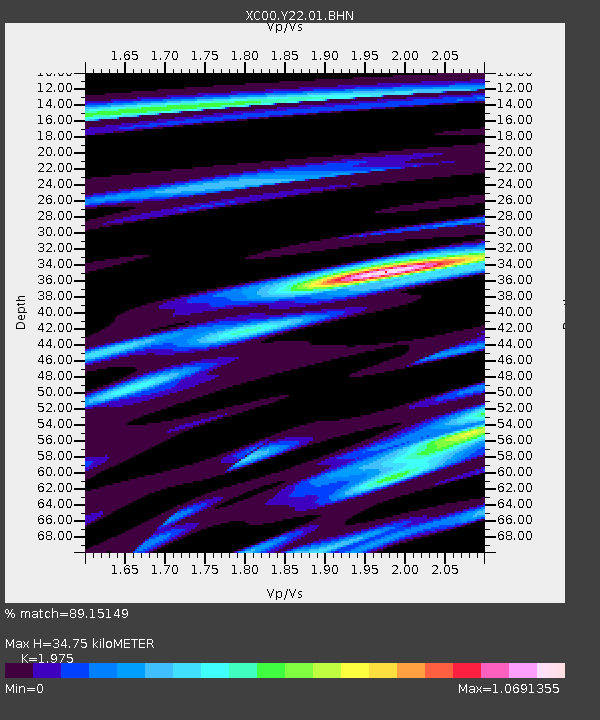
Y22 Y22 - Earthquake Result Viewer
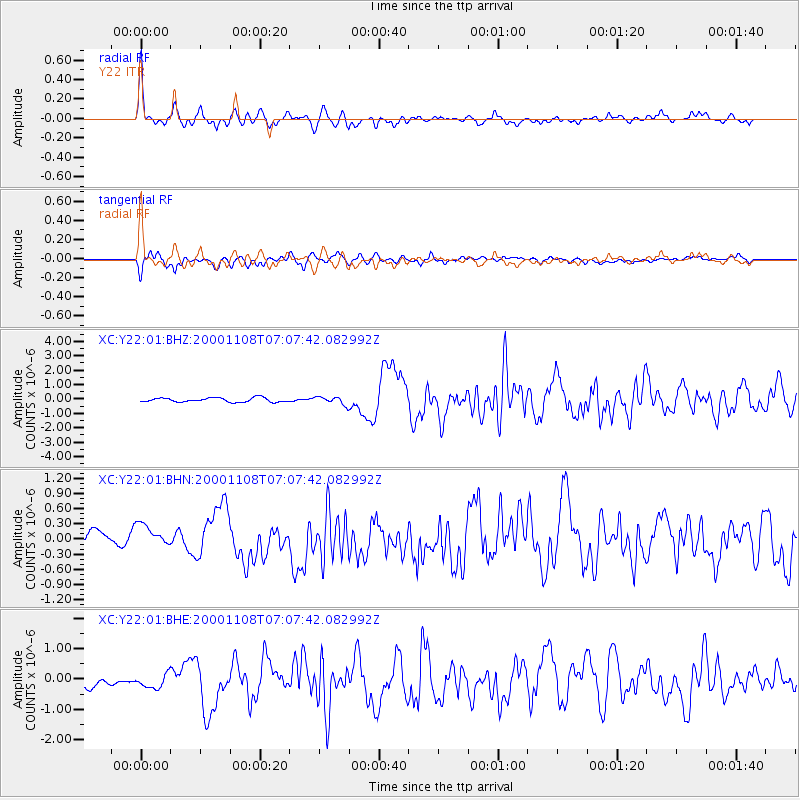
Earthquake location: Panama-Colombia Border Region
Earthquake latitude/longitude: 7.0/-77.8
Earthquake time(UTC): 2000/11/08 (313) 06:59:58 GMT
Earthquake Depth: 17 km
Earthquake Magnitude: 6.0 MB, 6.4 MS, 6.5 MW, 6.2 ML
Earthquake Catalog/Contributor: WHDF/NEIC
Network: XC Yellowstone Intermountain Seismic Array
Station: Y22 Y22
Lat/Lon: 42.59 N/109.25 W
Elevation: 2574 m
Distance: 45.0 deg
Az: 326.985 deg
Baz: 132.919 deg
Ray Param: 0.07157462
Estimated Moho Depth: 34.75 km
Estimated Crust Vp/Vs: 1.98
Assumed Crust Vp: 6.161 km/s
Estimated Crust Vs: 3.119 km/s
Estimated Crust Poisson's Ratio: 0.33
Radial Match: 89.15149 %
Radial Bump: 400
Transverse Match: 79.82827 %
Transverse Bump: 400
SOD ConfigId: 3744
Insert Time: 2010-02-26 15:01:00.833 +0000
GWidth: 2.5
Max Bumps: 400
Tol: 0.001

Signal To Noise

ChannelStoNSTALTA
XC:Y22:01:BHN:20001108T07:07:42.082992Z1.0949642.2795136E-72.081816E-7
XC:Y22:01:BHE:20001108T07:07:42.082992Z1.91703122.6528625E-71.383839E-7
XC:Y22:01:BHZ:20001108T07:07:42.082992Z1.71477712.5338662E-71.4776651E-7
Arrivals
Ps5.8 SECOND
PpPs16 SECOND
PsPs/PpSs22 SECOND