
Station XC Y22 - Y22
Network: XC00 - Yellowstone Intermountain Seismic Array
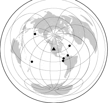
Nearby stations (2 deg radius)
| Station | Name | (Lat, Lon) | Start / End | Elevation |
| Y22 | Y22 | (42.59, -109.25) | 2000-06-20 / 2001-12-31 | 2574 m |
| Crust2 Type: | Q0,orogen/46km no ice, Rockies, Tarim Basin, 4 km seds. |
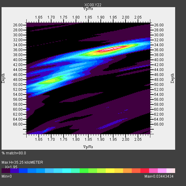
| Thickness Estimate: | 35 km |
| Thickness StdDev: | 5.1 km |
| Vp/Vs Estimate: | 1.95 |
| Vp/Vs StdDev: | 0.10 |
| Vs Estimate: | 3.159 km/s |
| Poisson's Ratio: | 0.32 |
| Peak Value: | 0.03 |
| Assumed Vp: | 6.161 km/s |
| Ps Weight: | 0.33333334 |
| PpPs Weight: | 0.33333334 |
| PsPs Weight: | 0.33333328 |
| Residual Complexity: | 0.570 |
| Nearby stations H: | +- |
| (2.0 deg) Vp/Vs: | +- |
1 with match > 90% ( 16.666666 %) and 6 with match > 80% ( 100.0 %) out of 6.
Download stack as xyz text file.
Azimuth Distribution of Events:
Prior Results for this Station
| Study | Thickness | Vp/Vs | Vp | Vs | Poissons Ratio | Extra |
| EARS | 35 km | 1.95 | 6.161 km/s | 3.159 km/s | 0.32 | |
| Crust2.0 | 46 km | 1.75 | 6.161 km/s | 3.511 km/s | 0.26 | Q0,orogen/46km no ice, Rockies, Tarim Basin, 4 km seds. |
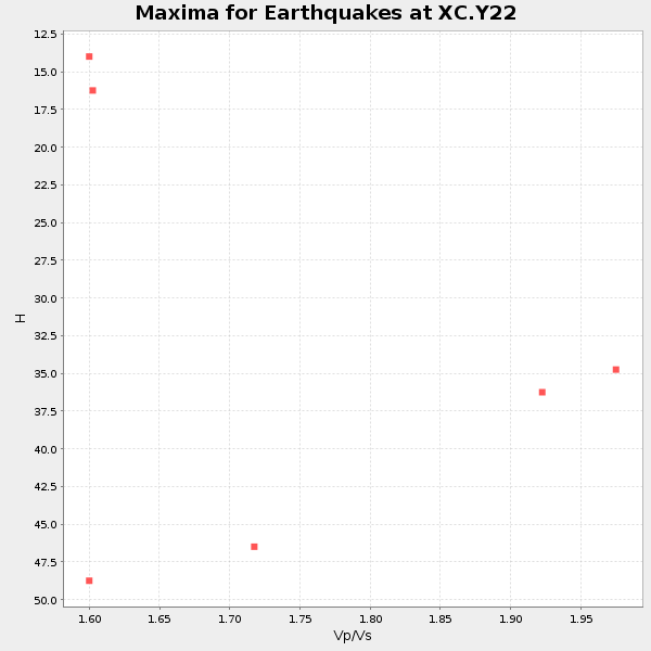
| Global Maxima | 35 km | 1.95 | 6.161 km/s | 3.159 km/s | 0.32 | amp=0.03443434 |
| Local Maxima 1 | 48 km | 1.69 | 6.161 km/s | 3.645 km/s | 0.23 | amp=0.019836016 |
| Local Maxima 2 | 37 km | 1.90 | 6.161 km/s | 3.247 km/s | 0.31 | amp=0.01328434 |
| Local Maxima 3 | 49 km | 1.72 | 6.161 km/s | 3.587 km/s | 0.24 | amp=0.010172229 |
| Local Maxima 4 | 40 km | 1.73 | 6.161 km/s | 3.556 km/s | 0.25 | amp=0.005955261 |
| Predicted Arrivals for vertical incidence (zero ray parameter) | |
| Ps | 5.44 SECOND |
| PpPs | 16.88 SECOND |
| PsPs/PpSs | 22.31 SECOND |
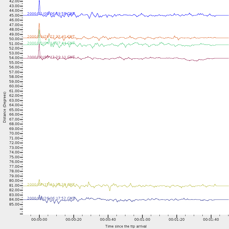
Events Processed for this Station
Download zip of receiver functions as SAC
Plot maxima for each earthquake.
Events Used in the Stack
(6 events)| Radial Match | Distance | Baz | FERegion | Time | Lat/Lon | Depth | Magnitude |
| 92.49319 | 49.8 deg | 141.09 deg | Near Coast Of Ecuador | 2000/09/28 23:23:43 GMT | (-0.2, -80.6) | 23 km | 5.8 MB, 6.0 MS, 6.6 MW, 6.4 MW |
| 89.15149 | 45.0 deg | 132.919 deg | Panama-Colombia Border Region | 2000/11/08 06:59:58 GMT | (7.0, -77.8) | 17 km | 6.0 MB, 6.4 MS, 6.5 MW, 6.2 ML |
| 84.00311 | 54.2 deg | 77.603 deg | Northern Mid-Atlantic Ridge | 2000/10/05 13:39:11 GMT | (31.7, -41.0) | 10 km | 5.4 MB, 6.1 MS, 6.0 MW, 5.9 MW |
| 83.28659 | 81.1 deg | 308.785 deg | Near S. Coast Of Honshu, Japan | 2000/07/15 01:30:30 GMT | (34.3, 139.3) | 10 km | 5.5 MB, 5.9 MS, 6.1 MW, 6.0 MW |
| 83.03274 | 51.2 deg | 113.623 deg | Windward Islands | 2000/10/04 14:37:44 GMT | (11.1, -62.6) | 110 km | 5.6 MB, 5.4 MS, 6.1 MW, 5.9 MD |
| 81.69264 | 84.0 deg | 240.319 deg | Tonga Islands | 2000/09/26 06:17:52 GMT | (-17.2, -173.9) | 56 km | 6.1 MB, 6.1 MS, 6.4 MW, 6.1 ME |
Losers
(0 events)| Radial Match | Distance | Baz | FERegion | Time | Lat/Lon | Depth | Magnitude | Reason |
