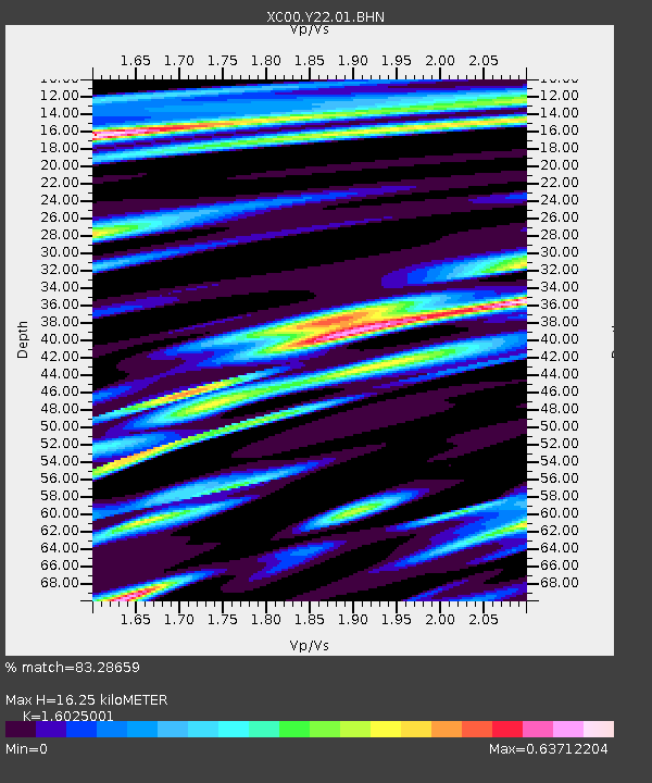
Y22 Y22 - Earthquake Result Viewer
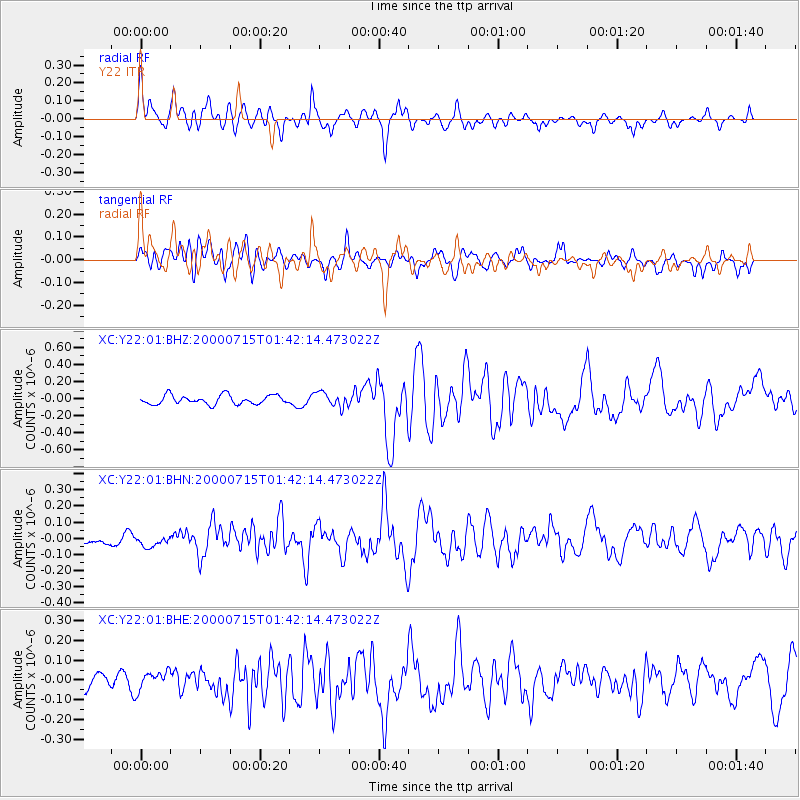
Earthquake location: Near S. Coast Of Honshu, Japan
Earthquake latitude/longitude: 34.3/139.3
Earthquake time(UTC): 2000/07/15 (197) 01:30:30 GMT
Earthquake Depth: 10 km
Earthquake Magnitude: 5.5 MB, 5.9 MS, 6.1 MW, 6.0 MW
Earthquake Catalog/Contributor: WHDF/NEIC
Network: XC Yellowstone Intermountain Seismic Array
Station: Y22 Y22
Lat/Lon: 42.59 N/109.25 W
Elevation: 2574 m
Distance: 81.1 deg
Az: 44.067 deg
Baz: 308.785 deg
Ray Param: 0.047816627
Estimated Moho Depth: 16.25 km
Estimated Crust Vp/Vs: 1.60
Assumed Crust Vp: 6.161 km/s
Estimated Crust Vs: 3.845 km/s
Estimated Crust Poisson's Ratio: 0.18
Radial Match: 83.28659 %
Radial Bump: 400
Transverse Match: 74.04265 %
Transverse Bump: 400
SOD ConfigId: 3744
Insert Time: 2010-02-26 15:01:02.857 +0000
GWidth: 2.5
Max Bumps: 400
Tol: 0.001

Signal To Noise

ChannelStoNSTALTA
XC:Y22:01:BHN:20000715T01:42:14.473022Z1.1472083.476156E-83.030101E-8
XC:Y22:01:BHE:20000715T01:42:14.473022Z1.31676724.662033E-83.5405144E-8
XC:Y22:01:BHZ:20000715T01:42:14.473022Z1.61307548.4071985E-85.2119066E-8
Arrivals
Ps1.6 SECOND
PpPs6.7 SECOND
PsPs/PpSs8.3 SECOND