You are here: Home > Network List > XC00 - Yellowstone Intermountain Seismic Array Stations List
> Station Y04 Y04 > Earthquake Result Viewer
Y04 Y04 - Earthquake Result Viewer
| Earthquake location: |
Fiji Islands Region |
| Earthquake latitude/longitude: |
-21.2/-179.1 |
| Earthquake time(UTC): |
2000/12/18 (353) 01:19:21 GMT |
| Earthquake Depth: |
628 km |
| Earthquake Magnitude: |
6.4 MB, 6.6 MW, 6.5 MW |
| Earthquake Catalog/Contributor: |
WHDF/NEIC |
|
| Network: |
XC Yellowstone Intermountain Seismic Array |
| Station: |
Y04 Y04 |
| Lat/Lon: |
43.51 N/111.90 W |
| Elevation: |
1502 m |
|
| Distance: |
89.1 deg |
| Az: |
42.135 deg |
| Baz: |
239.386 deg |
| Ray Param: |
0.04159541 |
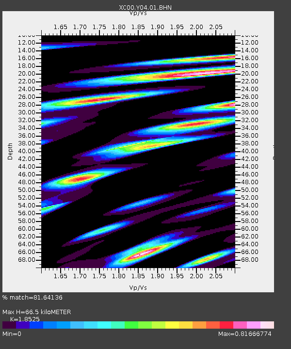
| Estimated Moho Depth: |
66.5 km |
| Estimated Crust Vp/Vs: |
1.85 |
| Assumed Crust Vp: |
6.207 km/s |
| Estimated Crust Vs: |
3.35 km/s |
| Estimated Crust Poisson's Ratio: |
0.29 |
|
| Radial Match: |
81.64136 % |
| Radial Bump: |
400 |
| Transverse Match: |
69.34895 % |
| Transverse Bump: |
400 |
| SOD ConfigId: |
16820 |
| Insert Time: |
2010-02-26 15:01:09.076 +0000 |
| GWidth: |
2.5 |
| Max Bumps: |
400 |
| Tol: |
0.001 |
|

Signal To Noise
| Channel | StoN | STA | LTA |
| XC:Y04:01:BHN:20001218T01:30:40.194006Z | 3.2781816 | 9.729989E-7 | 2.9681055E-7 |
| XC:Y04:01:BHE:20001218T01:30:40.194006Z | 4.1115127 | 1.4045534E-6 | 3.4161474E-7 |
| XC:Y04:01:BHZ:20001218T01:30:40.194006Z | 18.461294 | 5.8823393E-6 | 3.1863092E-7 |
| Arrivals |
| Ps | 9.3 SECOND |
| PpPs | 30 SECOND |
| PsPs/PpSs | 39 SECOND |


