
Station XC Y04 - Y04
Network: XC00 - Yellowstone Intermountain Seismic Array
Nearby stations (2 deg radius)
| Station | Name | (Lat, Lon) | Start / End | Elevation |
| Y04 | Y04 | (43.51, -111.90) | 2000-06-28 / 2001-12-31 | 1502 m |
| Crust2 Type: | M8,thick extended crust, 1.5 km seds. |
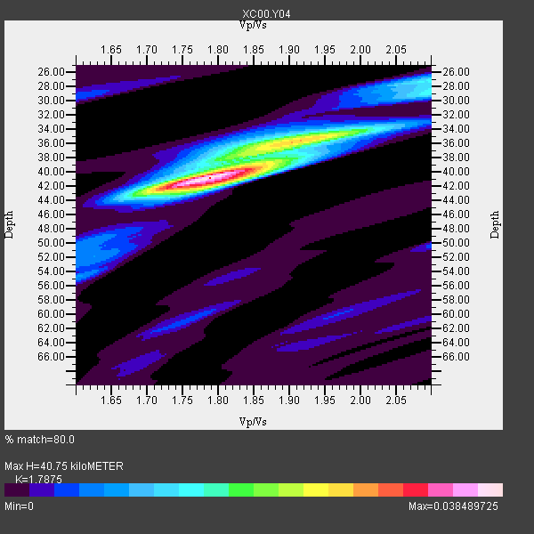
| Thickness Estimate: | 41 km |
| Thickness StdDev: | 2.0 km |
| Vp/Vs Estimate: | 1.79 |
| Vp/Vs StdDev: | 0.05 |
| Vs Estimate: | 3.472 km/s |
| Poisson's Ratio: | 0.27 |
| Peak Value: | 0.04 |
| Assumed Vp: | 6.207 km/s |
| Ps Weight: | 0.33333334 |
| PpPs Weight: | 0.33333334 |
| PsPs Weight: | 0.33333328 |
| Residual Complexity: | 0.534 |
| Nearby stations H: | +- |
| (2.0 deg) Vp/Vs: | +- |
2 with match > 90% ( 16.666666 %) and 12 with match > 80% ( 100.0 %) out of 12.
Download stack as xyz text file.
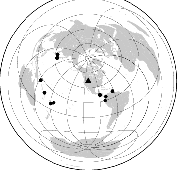
Azimuth Distribution of Events:
Prior Results for this Station
| Study | Thickness | Vp/Vs | Vp | Vs | Poissons Ratio | Extra |
| EARS | 41 km | 1.79 | 6.207 km/s | 3.472 km/s | 0.27 | |
| Crust2.0 | 37 km | 1.78 | 6.207 km/s | 3.489 km/s | 0.27 | M8,thick extended crust, 1.5 km seds. |
| Global Maxima | 41 km | 1.79 | 6.207 km/s | 3.472 km/s | 0.27 | amp=0.038489725 |
| Local Maxima 1 | 35 km | 1.93 | 6.207 km/s | 3.208 km/s | 0.32 | amp=0.022470187 |
| Local Maxima 2 | 27 km | 2.10 | 6.207 km/s | 2.959 km/s | 0.35 | amp=0.014618782 |
| Local Maxima 3 | 38 km | 1.85 | 6.207 km/s | 3.35 km/s | 0.29 | amp=0.009942741 |
| Local Maxima 4 | 42 km | 1.80 | 6.207 km/s | 3.453 km/s | 0.28 | amp=0.006618318 |
| Predicted Arrivals for vertical incidence (zero ray parameter) | |
| Ps | 5.17 SECOND |
| PpPs | 18.30 SECOND |
| PsPs/PpSs | 23.47 SECOND |
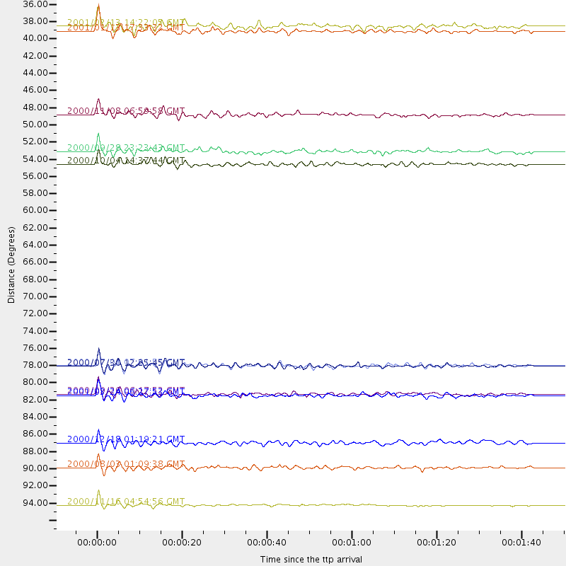
Events Processed for this Station
Download zip of receiver functions as SAC
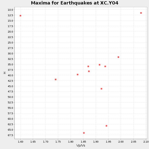
Plot maxima for each earthquake.
Events Used in the Stack
(12 events)| Radial Match | Distance | Baz | FERegion | Time | Lat/Lon | Depth | Magnitude |
| 93.74279 | 36.4 deg | 139.556 deg | El Salvador | 2001/01/13 17:33:32 GMT | (13.0, -88.7) | 60 km | 6.4 MB, 7.8 MS, 7.7 MW, 7.5 ME |
| 90.86566 | 82.8 deg | 238.311 deg | Tonga Islands | 2000/09/26 06:17:52 GMT | (-17.2, -173.9) | 56 km | 6.1 MB, 6.1 MS, 6.4 MW, 6.1 ME |
| 88.62074 | 79.2 deg | 306.697 deg | Southeast Of Honshu, Japan | 2000/07/30 12:25:45 GMT | (33.9, 139.4) | 10 km | 6.0 MB, 6.5 MS, 6.5 MW, 6.5 MW |
| 87.31809 | 35.7 deg | 139.448 deg | El Salvador | 2001/02/13 14:22:05 GMT | (13.7, -88.9) | 10 km | 5.5 MB, 6.5 MS, 6.6 MW, 6.1 MD |
| 87.04767 | 97.0 deg | 271.187 deg | New Ireland Region, P.N.G. | 2000/11/16 04:54:56 GMT | (-4.0, 152.2) | 33 km | 6.0 MB, 8.2 MS, 8.0 MW, 8.0 ME |
| 87.04556 | 79.2 deg | 307.073 deg | Near S. Coast Of Honshu, Japan | 2000/07/01 07:01:55 GMT | (34.2, 139.1) | 10 km | 6.0 MB, 6.1 MS, 6.2 MW, 6.2 MW |
| 86.51959 | 83.0 deg | 311.036 deg | Western Honshu, Japan | 2001/03/24 06:27:53 GMT | (34.1, 132.5) | 50 km | 6.4 MB, 6.5 MS, 6.8 MW, 6.4 ME |
| 85.14232 | 53.4 deg | 111.898 deg | Windward Islands | 2000/10/04 14:37:44 GMT | (11.1, -62.6) | 110 km | 5.6 MB, 5.4 MS, 6.1 MW, 5.9 MD |
| 84.517456 | 47.0 deg | 130.533 deg | Panama-Colombia Border Region | 2000/11/08 06:59:58 GMT | (7.0, -77.8) | 17 km | 6.0 MB, 6.4 MS, 6.5 MW, 6.2 ML |
| 83.214264 | 51.8 deg | 138.563 deg | Near Coast Of Ecuador | 2000/09/28 23:23:43 GMT | (-0.2, -80.6) | 23 km | 5.8 MB, 6.0 MS, 6.6 MW, 6.4 MW |
| 81.64136 | 89.1 deg | 239.386 deg | Fiji Islands Region | 2000/12/18 01:19:21 GMT | (-21.2, -179.1) | 628 km | 6.4 MB, 6.6 MW, 6.5 MW |
| 81.23443 | 92.2 deg | 255.618 deg | Santa Cruz Islands | 2000/08/03 01:09:38 GMT | (-12.0, 166.4) | 33 km | 5.7 MB, 6.5 MS, 6.7 MW, 6.6 MW |
Losers
(0 events)| Radial Match | Distance | Baz | FERegion | Time | Lat/Lon | Depth | Magnitude | Reason |
