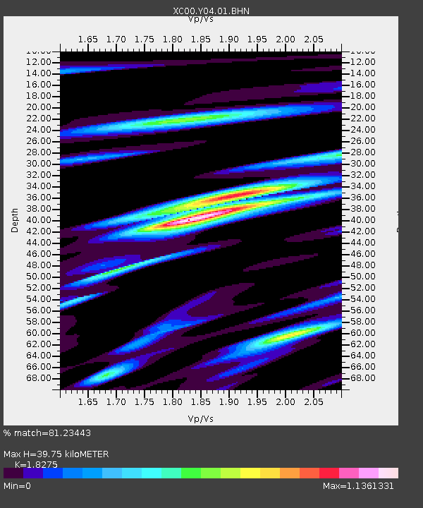
Y04 Y04 - Earthquake Result Viewer
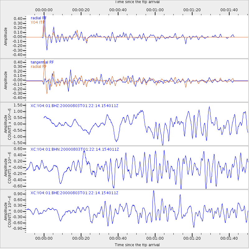
Earthquake location: Santa Cruz Islands
Earthquake latitude/longitude: -12.0/166.4
Earthquake time(UTC): 2000/08/03 (216) 01:09:38 GMT
Earthquake Depth: 33 km
Earthquake Magnitude: 5.7 MB, 6.5 MS, 6.7 MW, 6.6 MW
Earthquake Catalog/Contributor: WHDF/NEIC
Network: XC Yellowstone Intermountain Seismic Array
Station: Y04 Y04
Lat/Lon: 43.51 N/111.90 W
Elevation: 1502 m
Distance: 92.2 deg
Az: 46.084 deg
Baz: 255.618 deg
Ray Param: 0.04148208
Estimated Moho Depth: 39.75 km
Estimated Crust Vp/Vs: 1.83
Assumed Crust Vp: 6.207 km/s
Estimated Crust Vs: 3.396 km/s
Estimated Crust Poisson's Ratio: 0.29
Radial Match: 81.23443 %
Radial Bump: 400
Transverse Match: 78.9129 %
Transverse Bump: 400
SOD ConfigId: 16820
Insert Time: 2010-02-26 15:01:10.887 +0000
GWidth: 2.5
Max Bumps: 400
Tol: 0.001

Signal To Noise

ChannelStoNSTALTA
XC:Y04:01:BHN:20000803T01:22:14.154011Z0.999359379.149306E-89.1551705E-8
XC:Y04:01:BHE:20000803T01:22:14.154011Z1.07703041.3960319E-71.2961861E-7
XC:Y04:01:BHZ:20000803T01:22:14.154011Z1.02039683.33526E-73.2685912E-7
Arrivals
Ps5.4 SECOND
PpPs18 SECOND
PsPs/PpSs23 SECOND