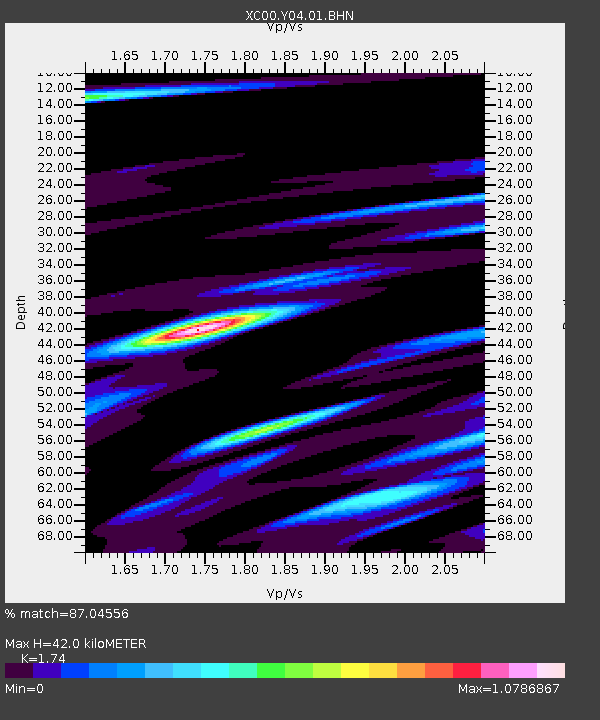
Y04 Y04 - Earthquake Result Viewer
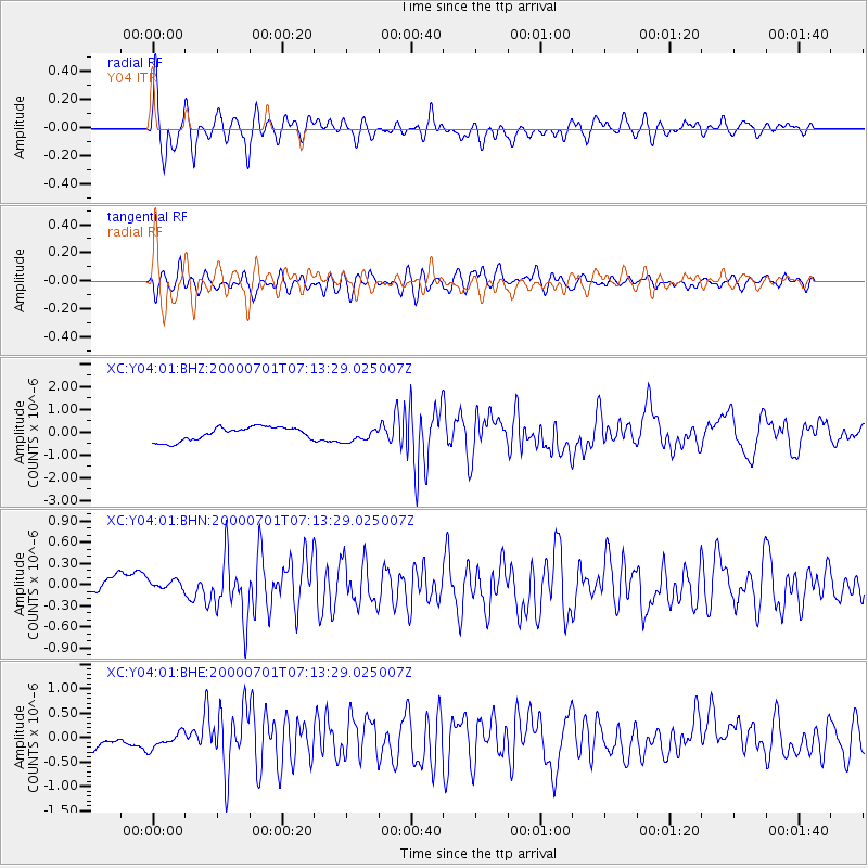
Earthquake location: Near S. Coast Of Honshu, Japan
Earthquake latitude/longitude: 34.2/139.1
Earthquake time(UTC): 2000/07/01 (183) 07:01:55 GMT
Earthquake Depth: 10 km
Earthquake Magnitude: 6.0 MB, 6.1 MS, 6.2 MW, 6.2 MW
Earthquake Catalog/Contributor: WHDF/NEIC
Network: XC Yellowstone Intermountain Seismic Array
Station: Y04 Y04
Lat/Lon: 43.51 N/111.90 W
Elevation: 1502 m
Distance: 79.2 deg
Az: 44.469 deg
Baz: 307.073 deg
Ray Param: 0.049153354
Estimated Moho Depth: 42.0 km
Estimated Crust Vp/Vs: 1.74
Assumed Crust Vp: 6.207 km/s
Estimated Crust Vs: 3.567 km/s
Estimated Crust Poisson's Ratio: 0.25
Radial Match: 87.04556 %
Radial Bump: 400
Transverse Match: 82.979675 %
Transverse Bump: 400
SOD ConfigId: 3744
Insert Time: 2010-02-26 15:01:16.689 +0000
GWidth: 2.5
Max Bumps: 400
Tol: 0.001

Signal To Noise

ChannelStoNSTALTA
XC:Y04:01:BHN:20000701T07:13:29.025007Z0.94691867.5772945E-88.002055E-8
XC:Y04:01:BHE:20000701T07:13:29.025007Z1.19917131.7563903E-71.46467E-7
XC:Y04:01:BHZ:20000701T07:13:29.025007Z0.99776122.9568744E-72.9635092E-7
Arrivals
Ps5.1 SECOND
PpPs18 SECOND
PsPs/PpSs23 SECOND