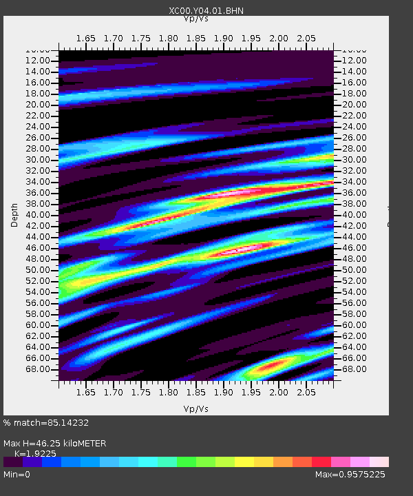
Y04 Y04 - Earthquake Result Viewer
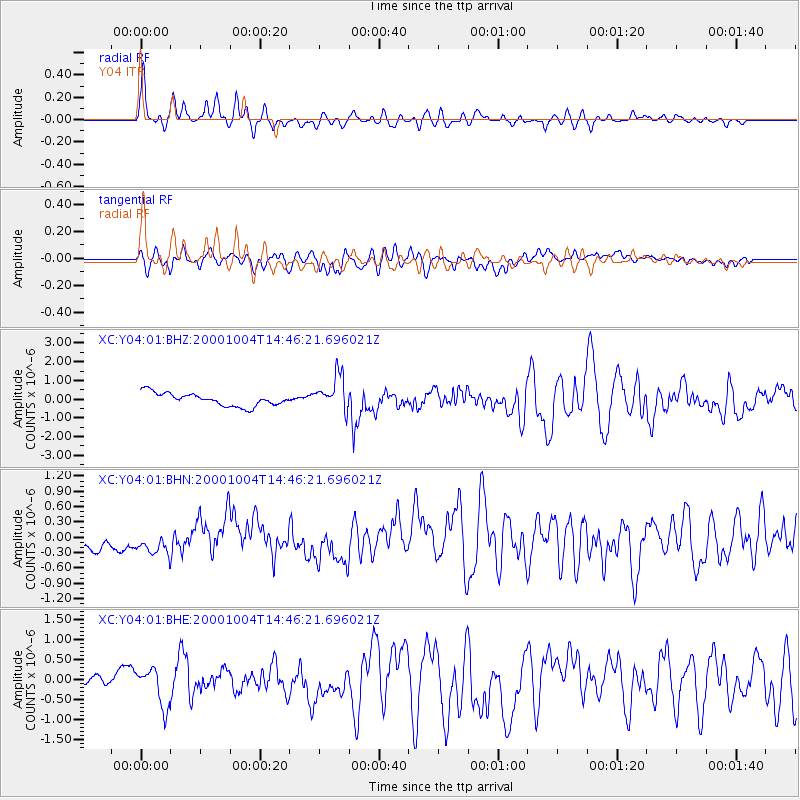
Earthquake location: Windward Islands
Earthquake latitude/longitude: 11.1/-62.6
Earthquake time(UTC): 2000/10/04 (278) 14:37:44 GMT
Earthquake Depth: 110 km
Earthquake Magnitude: 5.6 MB, 5.4 MS, 6.1 MW, 5.9 MD
Earthquake Catalog/Contributor: WHDF/NEIC
Network: XC Yellowstone Intermountain Seismic Array
Station: Y04 Y04
Lat/Lon: 43.51 N/111.90 W
Elevation: 1502 m
Distance: 53.4 deg
Az: 316.544 deg
Baz: 111.898 deg
Ray Param: 0.065790884
Estimated Moho Depth: 46.25 km
Estimated Crust Vp/Vs: 1.92
Assumed Crust Vp: 6.207 km/s
Estimated Crust Vs: 3.228 km/s
Estimated Crust Poisson's Ratio: 0.31
Radial Match: 85.14232 %
Radial Bump: 372
Transverse Match: 73.958015 %
Transverse Bump: 400
SOD ConfigId: 16820
Insert Time: 2010-02-26 15:01:17.674 +0000
GWidth: 2.5
Max Bumps: 400
Tol: 0.001

Signal To Noise

ChannelStoNSTALTA
XC:Y04:01:BHN:20001004T14:46:21.696021Z1.37559633.0219263E-72.1968118E-7
XC:Y04:01:BHE:20001004T14:46:21.696021Z2.28683234.7121722E-72.0605674E-7
XC:Y04:01:BHZ:20001004T14:46:21.696021Z2.6877239.241444E-73.4383916E-7
Arrivals
Ps7.2 SECOND
PpPs21 SECOND
PsPs/PpSs28 SECOND