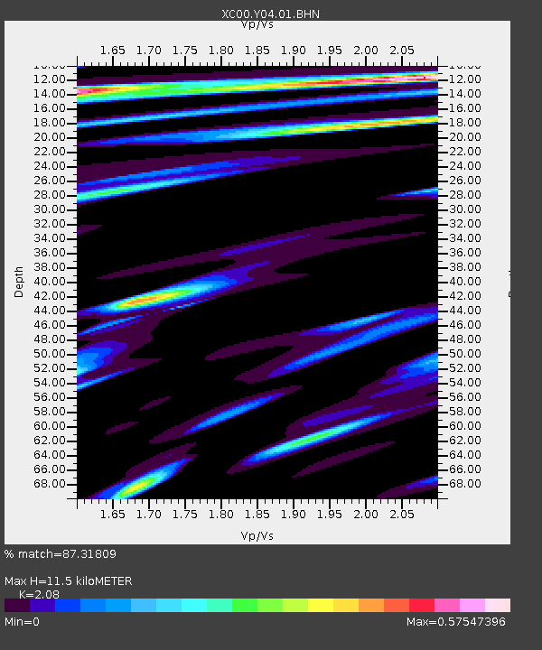
Y04 Y04 - Earthquake Result Viewer
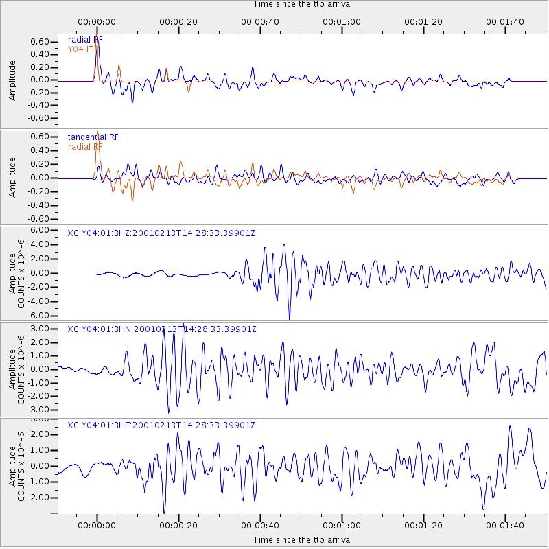
Earthquake location: El Salvador
Earthquake latitude/longitude: 13.7/-88.9
Earthquake time(UTC): 2001/02/13 (044) 14:22:05 GMT
Earthquake Depth: 10 km
Earthquake Magnitude: 5.5 MB, 6.5 MS, 6.6 MW, 6.1 MD
Earthquake Catalog/Contributor: WHDF/NEIC
Network: XC Yellowstone Intermountain Seismic Array
Station: Y04 Y04
Lat/Lon: 43.51 N/111.90 W
Elevation: 1502 m
Distance: 35.7 deg
Az: 330.882 deg
Baz: 139.448 deg
Ray Param: 0.07709207
Estimated Moho Depth: 11.5 km
Estimated Crust Vp/Vs: 2.08
Assumed Crust Vp: 6.207 km/s
Estimated Crust Vs: 2.984 km/s
Estimated Crust Poisson's Ratio: 0.35
Radial Match: 87.31809 %
Radial Bump: 377
Transverse Match: 72.49717 %
Transverse Bump: 400
SOD ConfigId: 3744
Insert Time: 2010-02-26 15:01:22.631 +0000
GWidth: 2.5
Max Bumps: 400
Tol: 0.001

Signal To Noise

ChannelStoNSTALTA
XC:Y04:01:BHN:20010213T14:28:33.39901Z1.19958362.3802853E-71.9842595E-7
XC:Y04:01:BHE:20010213T14:28:33.39901Z0.877681262.4378986E-72.7776582E-7
XC:Y04:01:BHZ:20010213T14:28:33.39901Z1.34475523.1439325E-72.337922E-7
Arrivals
Ps2.1 SECOND
PpPs5.4 SECOND
PsPs/PpSs7.5 SECOND