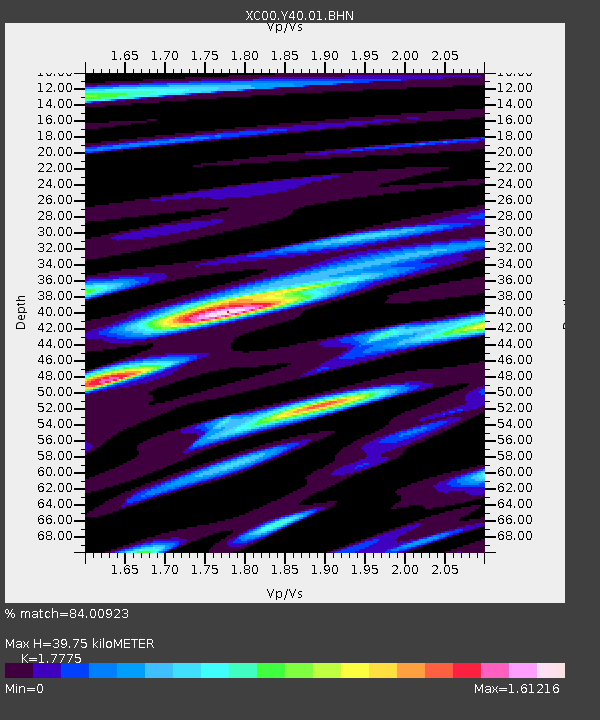
Y40 Y40 - Earthquake Result Viewer

Earthquake location: Near S. Coast Of Honshu, Japan
Earthquake latitude/longitude: 34.3/139.3
Earthquake time(UTC): 2000/07/15 (197) 01:30:30 GMT
Earthquake Depth: 10 km
Earthquake Magnitude: 5.5 MB, 5.9 MS, 6.1 MW, 6.0 MW
Earthquake Catalog/Contributor: WHDF/NEIC
Network: XC Yellowstone Intermountain Seismic Array
Station: Y40 Y40
Lat/Lon: 45.35 N/110.75 W
Elevation: 1547 m
Distance: 78.6 deg
Az: 42.539 deg
Baz: 307.476 deg
Ray Param: 0.049564168
Estimated Moho Depth: 39.75 km
Estimated Crust Vp/Vs: 1.78
Assumed Crust Vp: 6.35 km/s
Estimated Crust Vs: 3.572 km/s
Estimated Crust Poisson's Ratio: 0.27
Radial Match: 84.00923 %
Radial Bump: 400
Transverse Match: 64.58381 %
Transverse Bump: 400
SOD ConfigId: 3744
Insert Time: 2010-02-26 15:01:28.417 +0000
GWidth: 2.5
Max Bumps: 400
Tol: 0.001

Signal To Noise

ChannelStoNSTALTA
XC:Y40:01:BHN:20000715T01:42:00.63501Z0.77738831.10888095E-71.4264184E-7
XC:Y40:01:BHE:20000715T01:42:00.63501Z0.71948611.0164064E-71.4126837E-7
XC:Y40:01:BHZ:20000715T01:42:00.63501Z1.72524541.275409E-77.392624E-8
Arrivals
Ps5.0 SECOND
PpPs17 SECOND
PsPs/PpSs22 SECOND