
Station XC Y40 - Y40
Network: XC00 - Yellowstone Intermountain Seismic Array
Nearby stations (2 deg radius)
| Station | Name | (Lat, Lon) | Start / End | Elevation |
| Y40 | Y40 | (45.35, -110.75) | 2000-07-09 / 2001-12-31 | 1547 m |
| Crust2 Type: | P6,orogen/43km, Orogen, 0.5 km seds. |
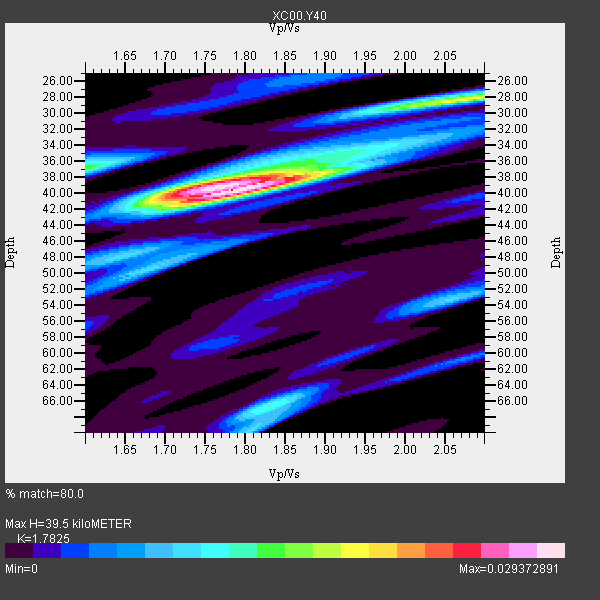
| Thickness Estimate: | 40 km |
| Thickness StdDev: | 6.3 km |
| Vp/Vs Estimate: | 1.78 |
| Vp/Vs StdDev: | 0.06 |
| Vs Estimate: | 3.562 km/s |
| Poisson's Ratio: | 0.27 |
| Peak Value: | 0.03 |
| Assumed Vp: | 6.35 km/s |
| Ps Weight: | 0.33333334 |
| PpPs Weight: | 0.33333334 |
| PsPs Weight: | 0.33333328 |
| Residual Complexity: | 0.613 |
| Nearby stations H: | +- |
| (2.0 deg) Vp/Vs: | +- |
5 with match > 90% ( 35.714287 %) and 14 with match > 80% ( 100.0 %) out of 14.
Download stack as xyz text file.
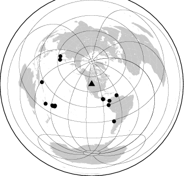
Azimuth Distribution of Events:
Prior Results for this Station
| Study | Thickness | Vp/Vs | Vp | Vs | Poissons Ratio | Extra |
| EARS | 40 km | 1.78 | 6.35 km/s | 3.562 km/s | 0.27 | |
| Crust2.0 | 43 km | 1.76 | 6.35 km/s | 3.609 km/s | 0.26 | P6,orogen/43km, Orogen, 0.5 km seds. |
| Global Maxima | 40 km | 1.78 | 6.35 km/s | 3.562 km/s | 0.27 | amp=0.029372891 |
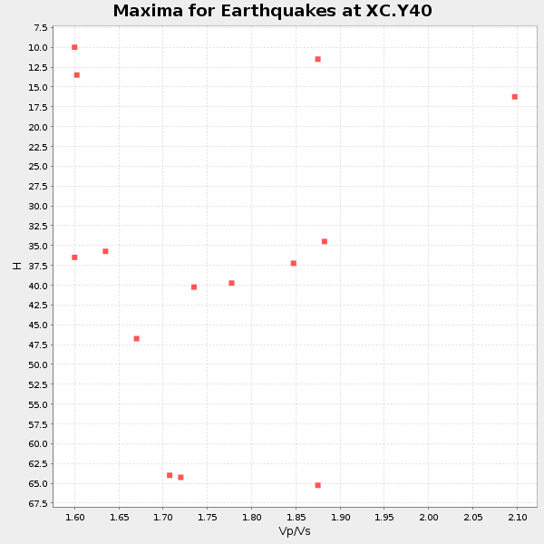
| Local Maxima 1 | 39 km | 1.75 | 6.35 km/s | 3.634 km/s | 0.26 | amp=0.017519778 |
| Local Maxima 2 | 28 km | 2.07 | 6.35 km/s | 3.068 km/s | 0.35 | amp=0.01670509 |
| Local Maxima 3 | 37 km | 1.60 | 6.35 km/s | 3.969 km/s | 0.18 | amp=0.013950935 |
| Local Maxima 4 | 66 km | 1.83 | 6.35 km/s | 3.475 km/s | 0.29 | amp=0.011845973 |
| Predicted Arrivals for vertical incidence (zero ray parameter) | |
| Ps | 4.87 SECOND |
| PpPs | 17.31 SECOND |
| PsPs/PpSs | 22.18 SECOND |
Events Processed for this Station
Download zip of receiver functions as SAC
Plot maxima for each earthquake.
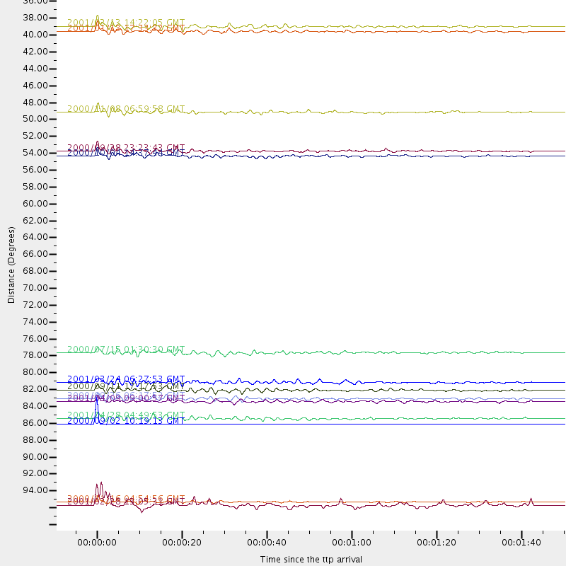
Events Used in the Stack
(14 events)| Radial Match | Distance | Baz | FERegion | Time | Lat/Lon | Depth | Magnitude |
| 99.9994 | 87.7 deg | 241.735 deg | Fiji Islands Region | 2000/09/02 10:19:13 GMT | (-17.9, -178.3) | 588 km | 5.1 MB, 5.8 MW, 5.7 MW |
| 93.823616 | 37.3 deg | 142.754 deg | El Salvador | 2001/01/13 17:33:32 GMT | (13.0, -88.7) | 60 km | 6.4 MB, 7.8 MS, 7.7 MW, 7.5 ME |
| 93.44442 | 98.1 deg | 247.012 deg | Southeast Of Loyalty Islands | 2001/02/28 13:05:31 GMT | (-22.0, 170.1) | 10 km | 5.8 MB, 6.1 MS, 6.2 MW |
| 92.5928 | 36.6 deg | 142.707 deg | El Salvador | 2001/02/13 14:22:05 GMT | (13.7, -88.9) | 10 km | 5.5 MB, 6.5 MS, 6.6 MW, 6.1 MD |
| 91.43567 | 52.6 deg | 140.774 deg | Near Coast Of Ecuador | 2000/09/28 23:23:43 GMT | (-0.2, -80.6) | 23 km | 5.8 MB, 6.0 MS, 6.6 MW, 6.4 MW |
| 88.22839 | 47.6 deg | 133.103 deg | Panama-Colombia Border Region | 2000/11/08 06:59:58 GMT | (7.0, -77.8) | 17 km | 6.0 MB, 6.4 MS, 6.5 MW, 6.2 ML |
| 86.5526 | 53.3 deg | 114.198 deg | Windward Islands | 2000/10/04 14:37:44 GMT | (11.1, -62.6) | 110 km | 5.6 MB, 5.4 MS, 6.1 MW, 5.9 MD |
| 86.43448 | 97.8 deg | 272.23 deg | New Ireland Region, P.N.G. | 2000/11/16 04:54:56 GMT | (-4.0, 152.2) | 33 km | 6.0 MB, 8.2 MS, 8.0 MW, 8.0 ME |
| 84.36836 | 84.5 deg | 238.984 deg | Tonga Islands | 2000/09/26 06:17:52 GMT | (-17.2, -173.9) | 56 km | 6.1 MB, 6.1 MS, 6.4 MW, 6.1 ME |
| 84.173485 | 84.8 deg | 148.852 deg | Off Coast Of Central Chile | 2001/04/09 09:00:57 GMT | (-32.7, -73.1) | 11 km | 6.1 MB, 6.3 MS, 6.7 MW, 6.3 ME |
| 84.00923 | 78.6 deg | 307.476 deg | Near S. Coast Of Honshu, Japan | 2000/07/15 01:30:30 GMT | (34.3, 139.3) | 10 km | 5.5 MB, 5.9 MS, 6.1 MW, 6.0 MW |
| 83.91172 | 87.0 deg | 240.634 deg | Fiji Islands Region | 2001/04/28 04:49:53 GMT | (-18.1, -176.9) | 352 km | 6.2 MB, 6.8 MW, 6.8 MW |
| 82.30842 | 82.4 deg | 311.589 deg | Western Honshu, Japan | 2001/03/24 06:27:53 GMT | (34.1, 132.5) | 50 km | 6.4 MB, 6.5 MS, 6.8 MW, 6.4 ME |
| 81.57333 | 83.3 deg | 239.63 deg | Tonga Islands | 2000/09/11 17:17:53 GMT | (-15.9, -173.7) | 115 km | 6.0 MB, 6.3 MW, 6.3 MW |
Losers
(0 events)| Radial Match | Distance | Baz | FERegion | Time | Lat/Lon | Depth | Magnitude | Reason |
