You are here: Home > Network List > SP - South Carolina Earth Physics Project Stations List
> Station BRNCH Branchville High School, Orangeburg County, SC USA > Earthquake Result Viewer
BRNCH Branchville High School, Orangeburg County, SC USA - Earthquake Result Viewer
| Earthquake location: |
Northern Algeria |
| Earthquake latitude/longitude: |
37.0/3.6 |
| Earthquake time(UTC): |
2003/05/21 (141) 18:44:20 GMT |
| Earthquake Depth: |
12 km |
| Earthquake Magnitude: |
6.5 MB, 6.9 MS, 6.8 MW, 6.7 MW |
| Earthquake Catalog/Contributor: |
WHDF/NEIC |
|
| Network: |
SP South Carolina Earth Physics Project |
| Station: |
BRNCH Branchville High School, Orangeburg County, SC USA |
| Lat/Lon: |
33.25 N/80.79 W |
| Elevation: |
53 m |
|
| Distance: |
66.9 deg |
| Az: |
294.965 deg |
| Baz: |
60.052 deg |
| Ray Param: |
0.0572877 |
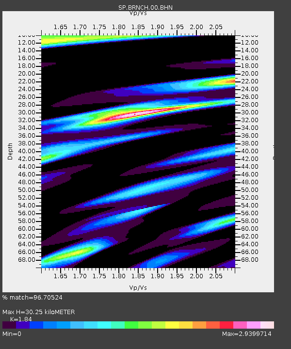
| Estimated Moho Depth: |
30.25 km |
| Estimated Crust Vp/Vs: |
1.84 |
| Assumed Crust Vp: |
6.565 km/s |
| Estimated Crust Vs: |
3.568 km/s |
| Estimated Crust Poisson's Ratio: |
0.29 |
|
| Radial Match: |
96.70524 % |
| Radial Bump: |
400 |
| Transverse Match: |
92.19678 % |
| Transverse Bump: |
400 |
| SOD ConfigId: |
2235 |
| Insert Time: |
2010-02-25 16:36:01.561 +0000 |
| GWidth: |
2.5 |
| Max Bumps: |
400 |
| Tol: |
0.001 |
|
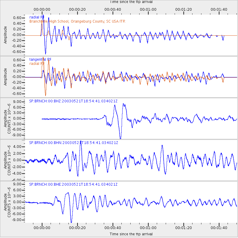
Signal To Noise
| Channel | StoN | STA | LTA |
| SP:BRNCH:00:BHN:20030521T18:54:41.034021Z | 1.1690004 | 3.5842504E-7 | 3.0660817E-7 |
| SP:BRNCH:00:BHE:20030521T18:54:41.034021Z | 1.3246726 | 2.2409232E-7 | 1.6916808E-7 |
| SP:BRNCH:00:BHZ:20030521T18:54:41.034021Z | 3.1004457 | 3.1275428E-7 | 1.0087397E-7 |
| Arrivals |
| Ps | 4.0 SECOND |
| PpPs | 13 SECOND |
| PsPs/PpSs | 17 SECOND |


