
Station SP BRNCH - Branchville High School, Orangeburg County, SC USA
Network: SP - South Carolina Earth Physics Project
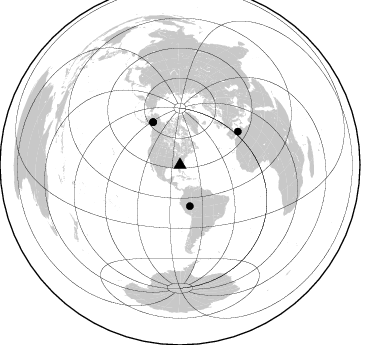
Nearby stations (2 deg radius)
| Station | Name | (Lat, Lon) | Start / End | Elevation |
| BRNCH | Branchville High School, Orangeburg County, SC USA | (33.25, -80.79) | 2001-09-11 / 2499-01-01 | 53 m |
| Crust2 Type: | DG,thin Platform 1 km seds. |
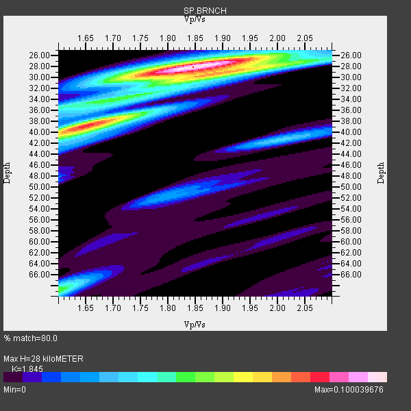
| Thickness Estimate: | 28 km |
| Thickness StdDev: | 4.8 km |
| Vp/Vs Estimate: | 1.85 |
| Vp/Vs StdDev: | 0.10 |
| Vs Estimate: | 3.558 km/s |
| Poisson's Ratio: | 0.29 |
| Peak Value: | 0.10 |
| Assumed Vp: | 6.565 km/s |
| Ps Weight: | 0.33333334 |
| PpPs Weight: | 0.33333334 |
| PsPs Weight: | 0.33333328 |
| Residual Complexity: | 0.633 |
| Nearby stations H: | +- |
| (2.0 deg) Vp/Vs: | +- |
4 with match > 90% ( 57.142857 %) and 4 with match > 80% ( 57.142857 %) out of 7.
Download stack as xyz text file.
Azimuth Distribution of Events:
Prior Results for this Station
| Study | Thickness | Vp/Vs | Vp | Vs | Poissons Ratio | Extra |
| EARS | 28 km | 1.85 | 6.565 km/s | 3.558 km/s | 0.29 | |
| Crust2.0 | 31 km | 1.78 | 6.565 km/s | 3.684 km/s | 0.27 | DG,thin Platform 1 km seds. |
| Global Maxima | 28 km | 1.85 | 6.565 km/s | 3.558 km/s | 0.29 | amp=0.100039676 |
| Local Maxima 1 | 39 km | 1.65 | 6.565 km/s | 3.978 km/s | 0.21 | amp=0.08134172 |
| Local Maxima 2 | 29 km | 1.91 | 6.565 km/s | 3.441 km/s | 0.31 | amp=0.058827654 |
| Local Maxima 3 | 69 km | 1.60 | 6.565 km/s | 4.103 km/s | 0.18 | amp=0.05030632 |
| Local Maxima 4 | 35 km | 1.60 | 6.565 km/s | 4.096 km/s | 0.18 | amp=0.034084857 |
| Predicted Arrivals for vertical incidence (zero ray parameter) | |
| Ps | 3.60 SECOND |
| PpPs | 12.13 SECOND |
| PsPs/PpSs | 15.74 SECOND |
Events Processed for this Station
Download zip of receiver functions as SAC
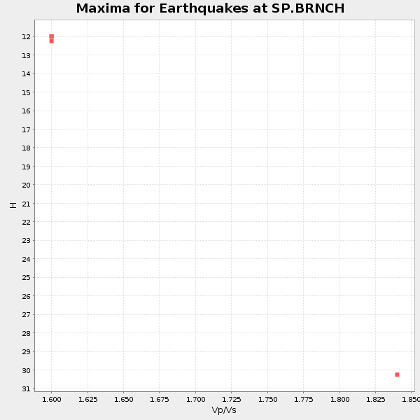
Plot maxima for each earthquake.
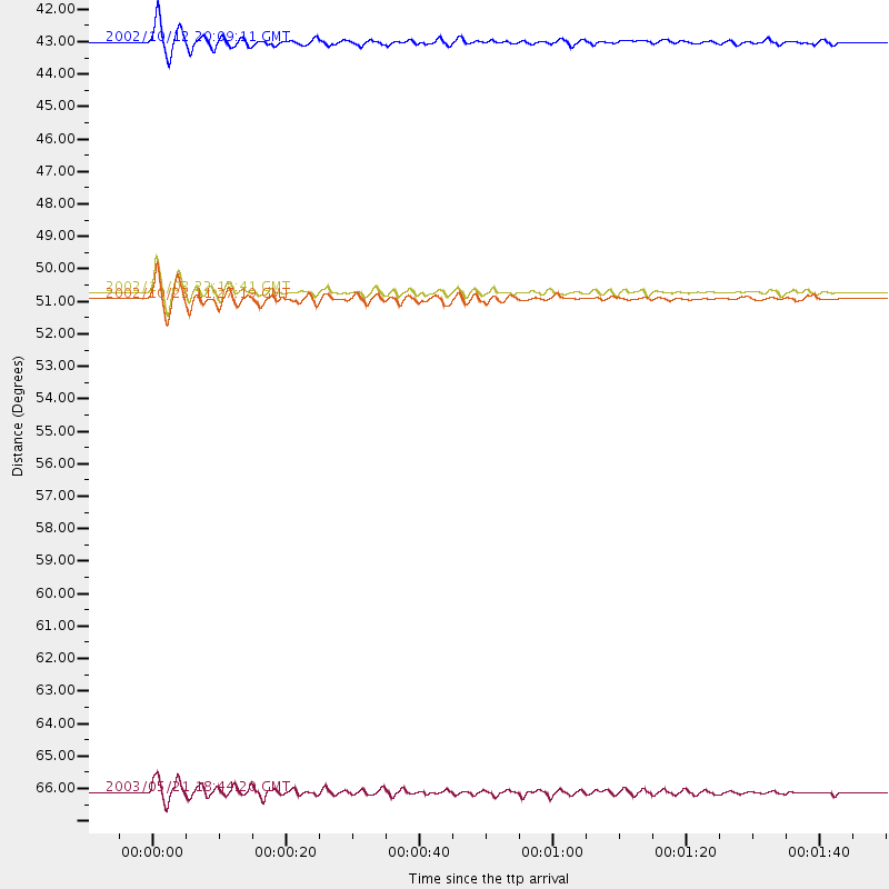
Events Used in the Stack
(4 events)| Radial Match | Distance | Baz | FERegion | Time | Lat/Lon | Depth | Magnitude |
| 96.91907 | 50.5 deg | 327.739 deg | Central Alaska | 2002/11/03 22:12:41 GMT | (63.5, -147.4) | 4.9 km | 7.0 MB, 8.5 MS, 7.9 MW |
| 96.70524 | 66.9 deg | 60.052 deg | Northern Algeria | 2003/05/21 18:44:20 GMT | (37.0, 3.6) | 12 km | 6.5 MB, 6.9 MS, 6.8 MW, 6.7 MW |
| 94.52432 | 42.2 deg | 166.596 deg | Western Brazil | 2002/10/12 20:09:11 GMT | (-8.3, -71.7) | 534 km | 6.5 MB, 6.9 MW, 6.9 MW |
| 91.92734 | 50.7 deg | 327.718 deg | Central Alaska | 2002/10/23 11:27:19 GMT | (63.5, -147.9) | 4.2 km | 6.0 MB, 6.7 MS, 6.7 MW, 6.7 MW |
Losers
(3 events)| Radial Match | Distance | Baz | FERegion | Time | Lat/Lon | Depth | Magnitude | Reason |
| 94.90602 | 55.9 deg | 165.969 deg | Chile-Bolivia Border Region | 2002/03/28 04:56:22 GMT | (-21.7, -68.3) | 125 km | 6.1 MB, 6.5 MW, 6.5 MW | |
| 93.52185 | 64.4 deg | 170.778 deg | Near Coast Of Central Chile | 2002/06/18 13:56:22 GMT | (-30.8, -71.1) | 54 km | 6.0 MB, 6.6 MW, 6.4 MW | |
| 89.22182 | 61.2 deg | 169.66 deg | Near Coast Of Northern Chile | 2002/04/18 16:08:36 GMT | (-27.5, -70.6) | 62 km | 6.2 MB, 6.7 MW, 6.6 MW |
