You are here: Home > Network List > XC00 - Yellowstone Intermountain Seismic Array Stations List
> Station Y40 Y40 > Earthquake Result Viewer
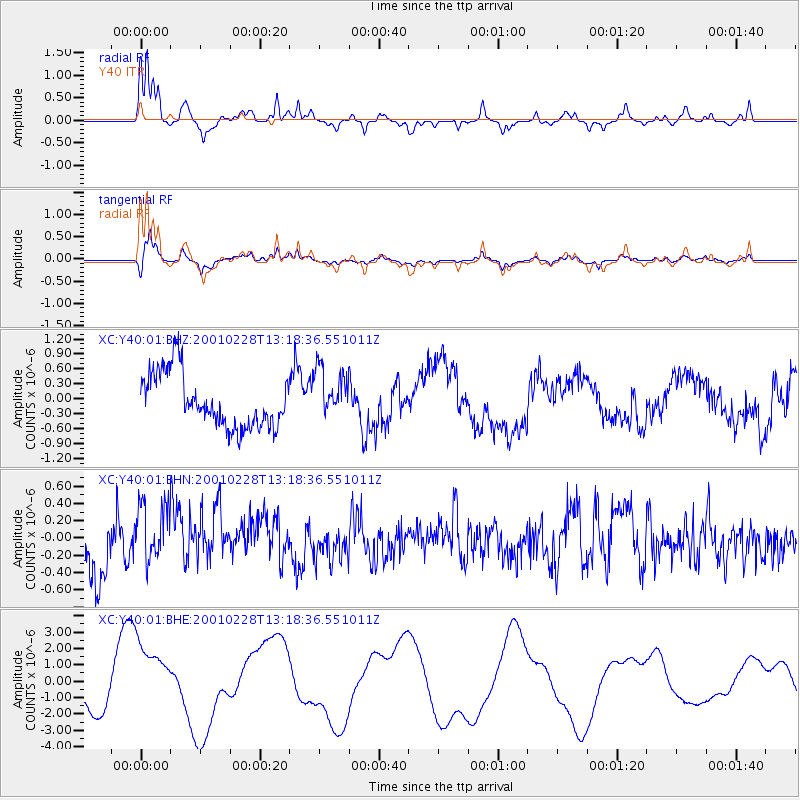
Y40 Y40 - Earthquake Result Viewer

| Earthquake location: |
Southeast Of Loyalty Islands |
| Earthquake latitude/longitude: |
-22.0/170.1 |
| Earthquake time(UTC): |
2001/02/28 (059) 13:05:31 GMT |
| Earthquake Depth: |
10 km |
| Earthquake Magnitude: |
5.8 MB, 6.1 MS, 6.2 MW |
| Earthquake Catalog/Contributor: |
WHDF/NEIC |
|
| Network: |
XC Yellowstone Intermountain Seismic Array |
| Station: |
Y40 Y40 |
| Lat/Lon: |
45.35 N/110.75 W |
| Elevation: |
1547 m |
|
| Distance: |
98.1 deg |
| Az: |
44.383 deg |
| Baz: |
247.012 deg |
| Ray Param: |
0.040010422 |
| Estimated Moho Depth: |
16.25 km |
| Estimated Crust Vp/Vs: |
2.10 |
| Assumed Crust Vp: |
6.35 km/s |
| Estimated Crust Vs: |
3.027 km/s |
| Estimated Crust Poisson's Ratio: |
0.35 |
|
| Radial Match: |
93.44442 % |
| Radial Bump: |
255 |
| Transverse Match: |
91.29297 % |
| Transverse Bump: |
317 |
| SOD ConfigId: |
3744 |
| Insert Time: |
2010-02-26 15:01:39.142 +0000 |
| GWidth: |
2.5 |
| Max Bumps: |
400 |
| Tol: |
0.001 |
|
Signal To Noise
| Channel | StoN | STA | LTA |
| XC:Y40:01:BHN:20010228T13:18:36.551011Z | 1.0506221 | 3.4656975E-7 | 3.29871E-7 |
| XC:Y40:01:BHE:20010228T13:18:36.551011Z | 1.2424394 | 2.0737282E-6 | 1.6690781E-6 |
| XC:Y40:01:BHZ:20010228T13:18:36.551011Z | 0.97227055 | 5.2603576E-7 | 5.4103845E-7 |
| Arrivals |
| Ps | 2.9 SECOND |
| PpPs | 7.8 SECOND |
| PsPs/PpSs | 11 SECOND |


