You are here: Home > Network List > XC00 - Yellowstone Intermountain Seismic Array Stations List
> Station Y40 Y40 > Earthquake Result Viewer
Y40 Y40 - Earthquake Result Viewer
| Earthquake location: |
Fiji Islands Region |
| Earthquake latitude/longitude: |
-18.1/-176.9 |
| Earthquake time(UTC): |
2001/04/28 (118) 04:49:53 GMT |
| Earthquake Depth: |
352 km |
| Earthquake Magnitude: |
6.2 MB, 6.8 MW, 6.8 MW |
| Earthquake Catalog/Contributor: |
WHDF/NEIC |
|
| Network: |
XC Yellowstone Intermountain Seismic Array |
| Station: |
Y40 Y40 |
| Lat/Lon: |
45.35 N/110.75 W |
| Elevation: |
1547 m |
|
| Distance: |
87.0 deg |
| Az: |
40.237 deg |
| Baz: |
240.634 deg |
| Ray Param: |
0.042746555 |
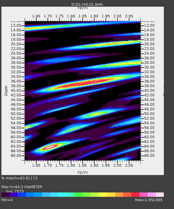
| Estimated Moho Depth: |
64.0 km |
| Estimated Crust Vp/Vs: |
1.71 |
| Assumed Crust Vp: |
6.35 km/s |
| Estimated Crust Vs: |
3.719 km/s |
| Estimated Crust Poisson's Ratio: |
0.24 |
|
| Radial Match: |
83.91172 % |
| Radial Bump: |
400 |
| Transverse Match: |
73.146675 % |
| Transverse Bump: |
400 |
| SOD ConfigId: |
4714 |
| Insert Time: |
2010-02-26 15:01:40.078 +0000 |
| GWidth: |
2.5 |
| Max Bumps: |
400 |
| Tol: |
0.001 |
|

Signal To Noise
| Channel | StoN | STA | LTA |
| XC:Y40:01:BHN:20010428T05:01:28.450996Z | 1.4299269 | 1.8240056E-7 | 1.2755936E-7 |
| XC:Y40:01:BHE:20010428T05:01:28.450996Z | 2.3486829 | 2.1776371E-7 | 9.271737E-8 |
| XC:Y40:01:BHZ:20010428T05:01:28.450996Z | 13.32564 | 8.50189E-7 | 6.380099E-8 |
| Arrivals |
| Ps | 7.3 SECOND |
| PpPs | 27 SECOND |
| PsPs/PpSs | 34 SECOND |


