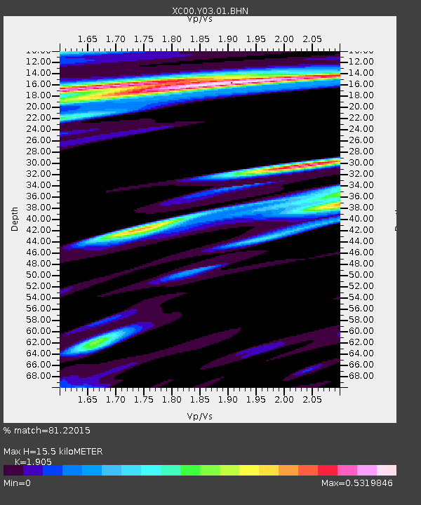
Y03 Y03 - Earthquake Result Viewer
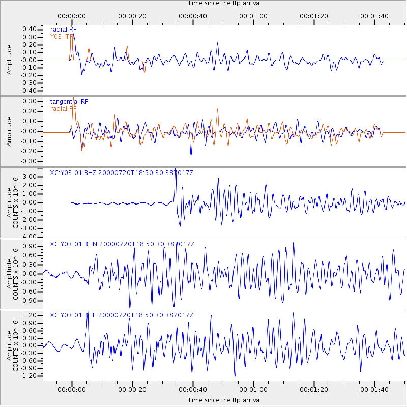
Earthquake location: Near East Coast Of Honshu, Japan
Earthquake latitude/longitude: 36.5/141.0
Earthquake time(UTC): 2000/07/20 (202) 18:39:18 GMT
Earthquake Depth: 47 km
Earthquake Magnitude: 6.1 MB, 5.4 MS, 6.1 ME, 6.0 MW
Earthquake Catalog/Contributor: WHDF/NEIC
Network: XC Yellowstone Intermountain Seismic Array
Station: Y03 Y03
Lat/Lon: 43.81 N/112.31 W
Elevation: 1478 m
Distance: 76.1 deg
Az: 45.605 deg
Baz: 307.336 deg
Ray Param: 0.05116618
Estimated Moho Depth: 15.5 km
Estimated Crust Vp/Vs: 1.90
Assumed Crust Vp: 6.279 km/s
Estimated Crust Vs: 3.296 km/s
Estimated Crust Poisson's Ratio: 0.31
Radial Match: 81.22015 %
Radial Bump: 400
Transverse Match: 73.141365 %
Transverse Bump: 400
SOD ConfigId: 16820
Insert Time: 2010-02-26 15:01:41.599 +0000
GWidth: 2.5
Max Bumps: 400
Tol: 0.001

Signal To Noise

ChannelStoNSTALTA
XC:Y03:01:BHN:20000720T18:50:30.387017Z1.17113451.0686201E-79.124658E-8
XC:Y03:01:BHE:20000720T18:50:30.387017Z2.64637472.2907251E-78.6560874E-8
XC:Y03:01:BHZ:20000720T18:50:30.387017Z18.3273351.1043821E-66.025874E-8
Arrivals
Ps2.3 SECOND
PpPs7.0 SECOND
PsPs/PpSs9.3 SECOND