
Station XC Y03 - Y03
Network: XC00 - Yellowstone Intermountain Seismic Array
Nearby stations (2 deg radius)
| Station | Name | (Lat, Lon) | Start / End | Elevation |
| Y03 | Y03 | (43.81, -112.31) | 2000-06-28 / 2001-12-31 | 1478 m |
| Crust2 Type: | M7,medium thick extended crust, 0.5 km seds. |
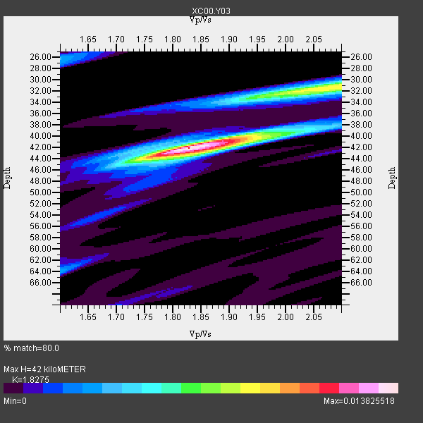
| Thickness Estimate: | 42 km |
| Thickness StdDev: | 3.9 km |
| Vp/Vs Estimate: | 1.83 |
| Vp/Vs StdDev: | 0.09 |
| Vs Estimate: | 3.436 km/s |
| Poisson's Ratio: | 0.29 |
| Peak Value: | 0.01 |
| Assumed Vp: | 6.279 km/s |
| Ps Weight: | 0.33333334 |
| PpPs Weight: | 0.33333334 |
| PsPs Weight: | 0.33333328 |
| Residual Complexity: | 0.555 |
| Nearby stations H: | +- |
| (2.0 deg) Vp/Vs: | +- |
7 with match > 90% ( 38.88889 %) and 18 with match > 80% ( 100.0 %) out of 18.
Download stack as xyz text file.
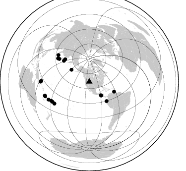
Azimuth Distribution of Events:
Prior Results for this Station
| Study | Thickness | Vp/Vs | Vp | Vs | Poissons Ratio | Extra |
| EARS | 42 km | 1.83 | 6.279 km/s | 3.436 km/s | 0.29 | |
| Crust2.0 | 35 km | 1.78 | 6.279 km/s | 3.533 km/s | 0.27 | M7,medium thick extended crust, 0.5 km seds. |
| Global Maxima | 42 km | 1.83 | 6.279 km/s | 3.436 km/s | 0.29 | amp=0.013825518 |
| Local Maxima 1 | 32 km | 2.05 | 6.279 km/s | 3.059 km/s | 0.34 | amp=0.008667957 |
| Local Maxima 2 | 42 km | 1.88 | 6.279 km/s | 3.335 km/s | 0.30 | amp=0.0053454596 |
| Local Maxima 3 | 26 km | 1.60 | 6.279 km/s | 3.924 km/s | 0.18 | amp=0.0035226177 |
| Local Maxima 4 | 32 km | 2.08 | 6.279 km/s | 3.019 km/s | 0.35 | amp=0.0034974476 |
| Predicted Arrivals for vertical incidence (zero ray parameter) | |
| Ps | 5.54 SECOND |
| PpPs | 18.91 SECOND |
| PsPs/PpSs | 24.45 SECOND |
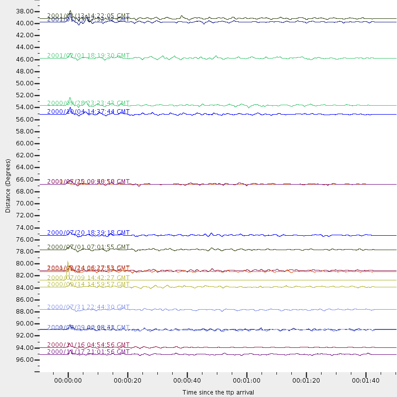
Events Processed for this Station
Download zip of receiver functions as SAC
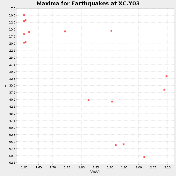
Plot maxima for each earthquake.
Events Used in the Stack
(18 events)| Radial Match | Distance | Baz | FERegion | Time | Lat/Lon | Depth | Magnitude |
| 99.99868 | 84.3 deg | 241.353 deg | Fiji Islands Region | 2000/07/09 14:42:27 GMT | (-16.2, -177.7) | 33 km | 5.0 MB, 5.5 MS |
| 99.94389 | 66.7 deg | 313.058 deg | Sea Of Okhotsk | 2000/07/10 09:58:18 GMT | (46.8, 145.4) | 360 km | 6.1 MB, 5.9 MW, 5.8 MW |
| 93.7208 | 53.8 deg | 111.73 deg | Windward Islands | 2000/10/04 14:37:44 GMT | (11.1, -62.6) | 110 km | 5.6 MB, 5.4 MS, 6.1 MW, 5.9 MD |
| 92.301636 | 82.7 deg | 237.975 deg | Tonga Islands | 2000/09/26 06:17:52 GMT | (-17.2, -173.9) | 56 km | 6.1 MB, 6.1 MS, 6.4 MW, 6.1 ME |
| 91.18669 | 96.7 deg | 270.937 deg | New Ireland Region, P.N.G. | 2000/11/16 04:54:56 GMT | (-4.0, 152.2) | 33 km | 6.0 MB, 8.2 MS, 8.0 MW, 8.0 ME |
| 91.1048 | 36.8 deg | 139.22 deg | El Salvador | 2001/01/13 17:33:32 GMT | (13.0, -88.7) | 60 km | 6.4 MB, 7.8 MS, 7.7 MW, 7.5 ME |
| 90.457245 | 52.2 deg | 138.254 deg | Near Coast Of Ecuador | 2000/09/28 23:23:43 GMT | (-0.2, -80.6) | 23 km | 5.8 MB, 6.0 MS, 6.6 MW, 6.4 MW |
| 88.089516 | 82.6 deg | 310.748 deg | Western Honshu, Japan | 2001/03/24 06:27:53 GMT | (34.1, 132.5) | 50 km | 6.4 MB, 6.5 MS, 6.8 MW, 6.4 ME |
| 86.30807 | 93.5 deg | 251.7 deg | Vanuatu Islands | 2000/08/09 00:08:41 GMT | (-15.7, 168.0) | 33 km | 6.3 MB, 6.0 MS, 6.4 MW, 6.3 MW |
| 85.83717 | 78.7 deg | 306.777 deg | Near S. Coast Of Honshu, Japan | 2000/07/01 07:01:55 GMT | (34.2, 139.1) | 10 km | 6.0 MB, 6.1 MS, 6.2 MW, 6.2 MW |
| 84.15744 | 36.1 deg | 139.111 deg | El Salvador | 2001/02/13 14:22:05 GMT | (13.7, -88.9) | 10 km | 5.5 MB, 6.5 MS, 6.6 MW, 6.1 MD |
| 83.9809 | 98.0 deg | 270.101 deg | New Britain Region, P.N.G. | 2000/11/17 21:01:56 GMT | (-5.5, 151.8) | 33 km | 6.2 MB, 8.0 MS, 7.6 MW, 6.9 ME |
| 82.86529 | 66.7 deg | 309.462 deg | Kuril Islands | 2001/05/25 00:40:50 GMT | (44.3, 148.4) | 33 km | 6.1 MB, 6.7 MS, 6.7 MW, 6.6 MW |
| 82.03876 | 85.6 deg | 243.475 deg | Fiji Islands | 2000/09/14 14:59:57 GMT | (-15.7, 179.8) | 33 km | 5.7 MB, 6.2 MS, 6.3 MW, 6.2 MW |
| 81.22015 | 76.1 deg | 307.336 deg | Near East Coast Of Honshu, Japan | 2000/07/20 18:39:18 GMT | (36.5, 141.0) | 47 km | 6.1 MB, 5.4 MS, 6.1 ME, 6.0 MW |
| 80.86953 | 43.4 deg | 304.093 deg | Andreanof Islands, Aleutian Is. | 2001/02/01 18:19:30 GMT | (51.4, -177.8) | 33 km | 5.6 MB, 5.6 MS, 6.0 MW, 5.9 MW |
| 80.63952 | 93.5 deg | 252.796 deg | Vanuatu Islands | 2001/01/09 16:49:28 GMT | (-14.9, 167.2) | 103 km | 6.3 MB, 6.6 MS, 7.6 ME, 7.0 MW |
| 80.61712 | 89.8 deg | 246.519 deg | Fiji Islands Region | 2000/07/31 22:44:30 GMT | (-16.7, 174.5) | 10 km | 5.7 MB, 5.6 MS, 6.1 MW, 6.1 MW |
Losers
(0 events)| Radial Match | Distance | Baz | FERegion | Time | Lat/Lon | Depth | Magnitude | Reason |
