You are here: Home > Network List > XC00 - Yellowstone Intermountain Seismic Array Stations List
> Station Y03 Y03 > Earthquake Result Viewer
Y03 Y03 - Earthquake Result Viewer
| Earthquake location: |
Fiji Islands Region |
| Earthquake latitude/longitude: |
-16.2/-177.7 |
| Earthquake time(UTC): |
2000/07/09 (191) 14:42:27 GMT |
| Earthquake Depth: |
33 km |
| Earthquake Magnitude: |
5.0 MB, 5.5 MS |
| Earthquake Catalog/Contributor: |
WHDF/NEIC |
|
| Network: |
XC Yellowstone Intermountain Seismic Array |
| Station: |
Y03 Y03 |
| Lat/Lon: |
43.81 N/112.31 W |
| Elevation: |
1478 m |
|
| Distance: |
84.3 deg |
| Az: |
41.403 deg |
| Baz: |
241.353 deg |
| Ray Param: |
0.045507256 |
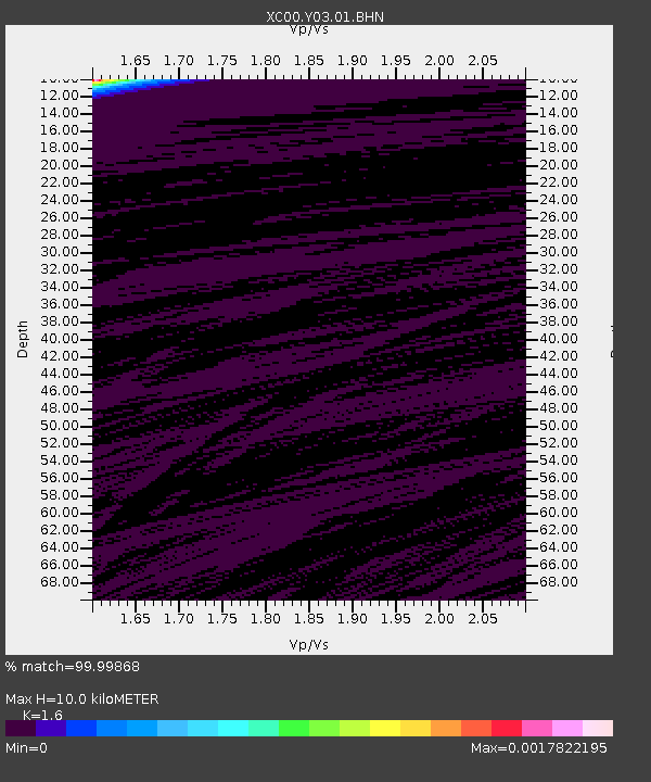
| Estimated Moho Depth: |
10.0 km |
| Estimated Crust Vp/Vs: |
1.60 |
| Assumed Crust Vp: |
6.279 km/s |
| Estimated Crust Vs: |
3.924 km/s |
| Estimated Crust Poisson's Ratio: |
0.18 |
|
| Radial Match: |
99.99868 % |
| Radial Bump: |
2 |
| Transverse Match: |
99.992935 % |
| Transverse Bump: |
2 |
| SOD ConfigId: |
16820 |
| Insert Time: |
2010-02-26 15:01:44.327 +0000 |
| GWidth: |
2.5 |
| Max Bumps: |
400 |
| Tol: |
0.001 |
|
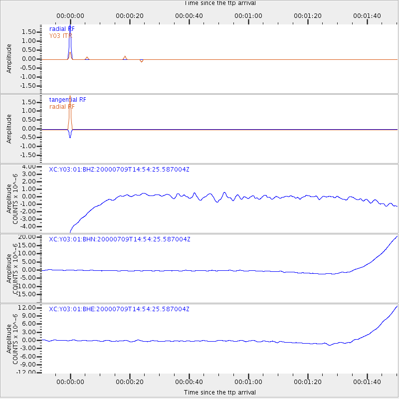
Signal To Noise
| Channel | StoN | STA | LTA |
| XC:Y03:01:BHN:20000709T14:54:25.587004Z | 0.9282777 | 1.6320554E-6 | 1.7581543E-6 |
| XC:Y03:01:BHE:20000709T14:54:25.587004Z | 0.929104 | 9.715147E-7 | 1.045647E-6 |
| XC:Y03:01:BHZ:20000709T14:54:25.587004Z | 0.91253 | 1.3151099E-6 | 1.441169E-6 |
| Arrivals |
| Ps | 1.0 SECOND |
| PpPs | 4.0 SECOND |
| PsPs/PpSs | 5.0 SECOND |


