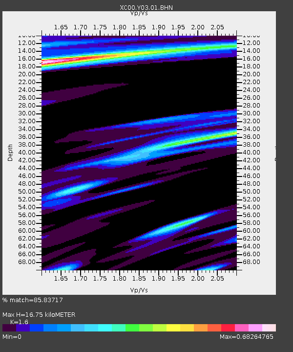
Y03 Y03 - Earthquake Result Viewer
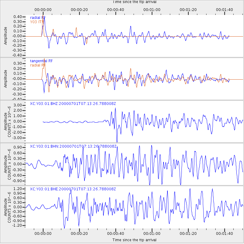
Earthquake location: Near S. Coast Of Honshu, Japan
Earthquake latitude/longitude: 34.2/139.1
Earthquake time(UTC): 2000/07/01 (183) 07:01:55 GMT
Earthquake Depth: 10 km
Earthquake Magnitude: 6.0 MB, 6.1 MS, 6.2 MW, 6.2 MW
Earthquake Catalog/Contributor: WHDF/NEIC
Network: XC Yellowstone Intermountain Seismic Array
Station: Y03 Y03
Lat/Lon: 43.81 N/112.31 W
Elevation: 1478 m
Distance: 78.7 deg
Az: 44.415 deg
Baz: 306.777 deg
Ray Param: 0.049435657
Estimated Moho Depth: 16.75 km
Estimated Crust Vp/Vs: 1.60
Assumed Crust Vp: 6.279 km/s
Estimated Crust Vs: 3.924 km/s
Estimated Crust Poisson's Ratio: 0.18
Radial Match: 85.83717 %
Radial Bump: 400
Transverse Match: 78.64416 %
Transverse Bump: 400
SOD ConfigId: 3744
Insert Time: 2010-02-26 15:01:50.099 +0000
GWidth: 2.5
Max Bumps: 400
Tol: 0.001

Signal To Noise

ChannelStoNSTALTA
XC:Y03:01:BHN:20000701T07:13:26.788008Z0.48416524.41106E-89.1106514E-8
XC:Y03:01:BHE:20000701T07:13:26.788008Z0.8005289.617993E-81.2014561E-7
XC:Y03:01:BHZ:20000701T07:13:26.788008Z1.54034361.3875228E-79.0078785E-8
Arrivals
Ps1.7 SECOND
PpPs6.7 SECOND
PsPs/PpSs8.4 SECOND