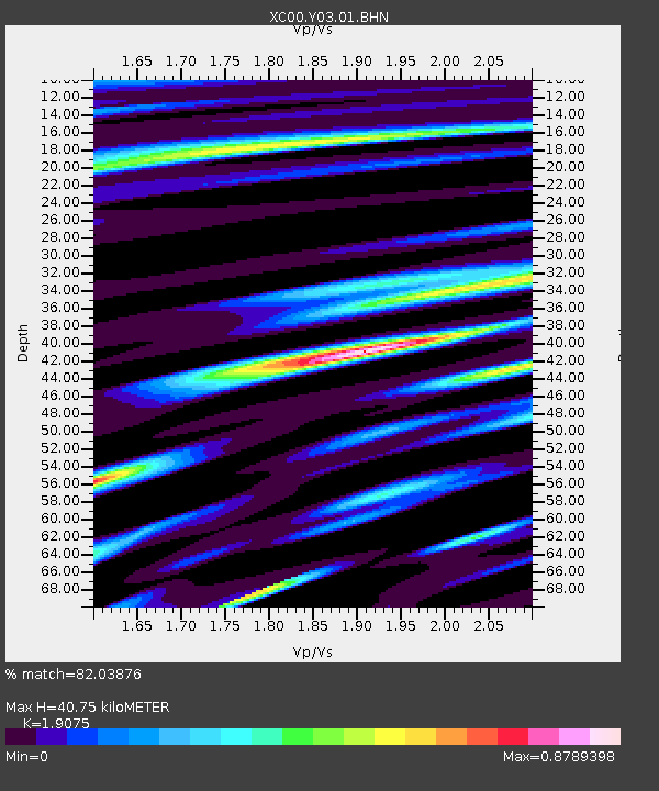
Y03 Y03 - Earthquake Result Viewer
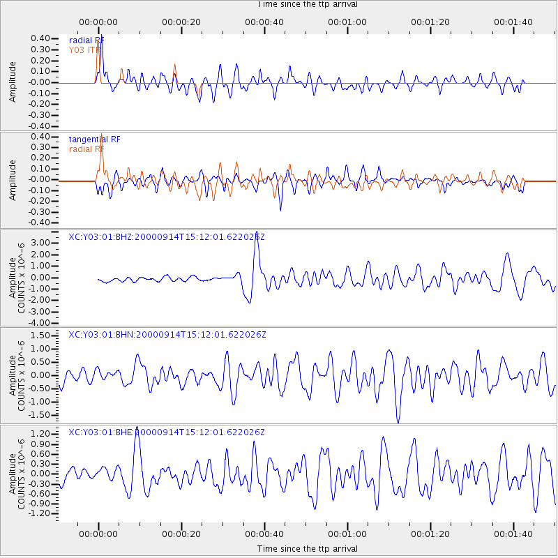
Earthquake location: Fiji Islands
Earthquake latitude/longitude: -15.7/179.8
Earthquake time(UTC): 2000/09/14 (258) 14:59:57 GMT
Earthquake Depth: 33 km
Earthquake Magnitude: 5.7 MB, 6.2 MS, 6.3 MW, 6.2 MW
Earthquake Catalog/Contributor: WHDF/NEIC
Network: XC Yellowstone Intermountain Seismic Array
Station: Y03 Y03
Lat/Lon: 43.81 N/112.31 W
Elevation: 1478 m
Distance: 85.6 deg
Az: 42.277 deg
Baz: 243.475 deg
Ray Param: 0.044596232
Estimated Moho Depth: 40.75 km
Estimated Crust Vp/Vs: 1.91
Assumed Crust Vp: 6.279 km/s
Estimated Crust Vs: 3.292 km/s
Estimated Crust Poisson's Ratio: 0.31
Radial Match: 82.03876 %
Radial Bump: 400
Transverse Match: 73.61112 %
Transverse Bump: 400
SOD ConfigId: 16820
Insert Time: 2010-02-26 15:01:54.380 +0000
GWidth: 2.5
Max Bumps: 400
Tol: 0.001

Signal To Noise

ChannelStoNSTALTA
XC:Y03:01:BHN:20000914T15:12:01.622026Z1.16371552.5749443E-72.2126922E-7
XC:Y03:01:BHE:20000914T15:12:01.622026Z0.991984672.1043464E-72.1213496E-7
XC:Y03:01:BHZ:20000914T15:12:01.622026Z1.69772583.0129834E-71.7747173E-7
Arrivals
Ps6.0 SECOND
PpPs18 SECOND
PsPs/PpSs24 SECOND