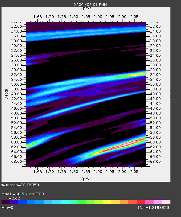
Y03 Y03 - Earthquake Result Viewer
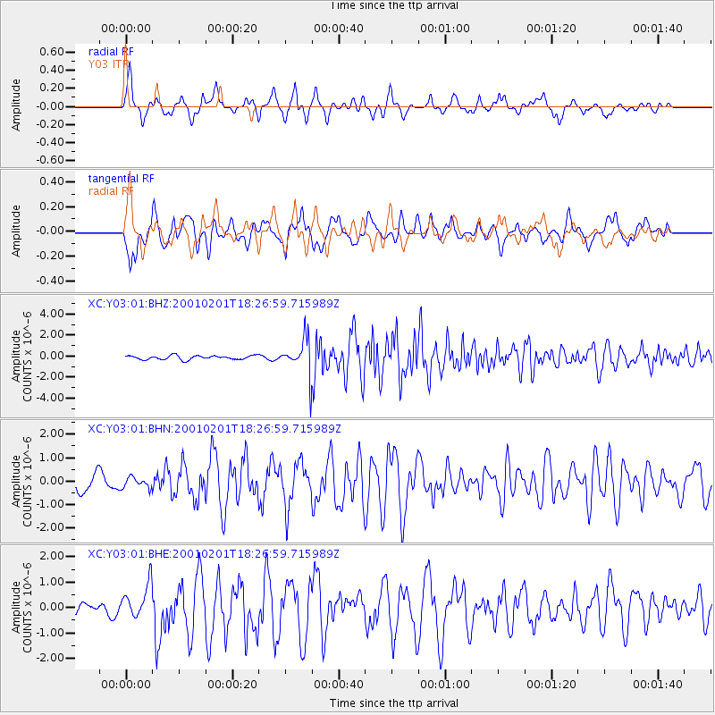
Earthquake location: Andreanof Islands, Aleutian Is.
Earthquake latitude/longitude: 51.4/-177.8
Earthquake time(UTC): 2001/02/01 (032) 18:19:30 GMT
Earthquake Depth: 33 km
Earthquake Magnitude: 5.6 MB, 5.6 MS, 6.0 MW, 5.9 MW
Earthquake Catalog/Contributor: WHDF/NEIC
Network: XC Yellowstone Intermountain Seismic Array
Station: Y03 Y03
Lat/Lon: 43.81 N/112.31 W
Elevation: 1478 m
Distance: 43.4 deg
Az: 73.315 deg
Baz: 304.093 deg
Ray Param: 0.072478965
Estimated Moho Depth: 60.5 km
Estimated Crust Vp/Vs: 2.02
Assumed Crust Vp: 6.279 km/s
Estimated Crust Vs: 3.108 km/s
Estimated Crust Poisson's Ratio: 0.34
Radial Match: 80.86953 %
Radial Bump: 400
Transverse Match: 76.834915 %
Transverse Bump: 400
SOD ConfigId: 16820
Insert Time: 2010-02-26 15:01:57.036 +0000
GWidth: 2.5
Max Bumps: 400
Tol: 0.001

Signal To Noise

ChannelStoNSTALTA
XC:Y03:01:BHN:20010201T18:26:59.715989Z0.525733652.210056E-74.203756E-7
XC:Y03:01:BHE:20010201T18:26:59.715989Z1.80623916.42838E-73.558986E-7
XC:Y03:01:BHZ:20010201T18:26:59.715989Z8.855781.6608369E-61.8754271E-7
Arrivals
Ps10 SECOND
PpPs28 SECOND
PsPs/PpSs38 SECOND