You are here: Home > Network List > XC00 - Yellowstone Intermountain Seismic Array Stations List
> Station Y24 Y24 > Earthquake Result Viewer
Y24 Y24 - Earthquake Result Viewer
| Earthquake location: |
Bonin Islands, Japan Region |
| Earthquake latitude/longitude: |
26.3/140.5 |
| Earthquake time(UTC): |
2000/10/27 (301) 04:21:51 GMT |
| Earthquake Depth: |
388 km |
| Earthquake Magnitude: |
6.1 MB, 6.1 MW, 6.0 MW |
| Earthquake Catalog/Contributor: |
WHDF/NEIC |
|
| Network: |
XC Yellowstone Intermountain Seismic Array |
| Station: |
Y24 Y24 |
| Lat/Lon: |
45.98 N/112.62 W |
| Elevation: |
1741 m |
|
| Distance: |
82.3 deg |
| Az: |
42.306 deg |
| Baz: |
299.916 deg |
| Ray Param: |
0.045902845 |
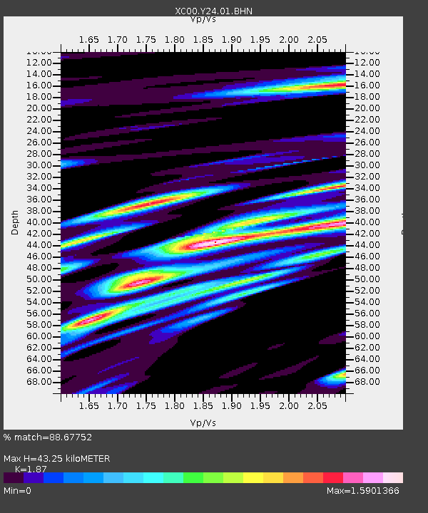
| Estimated Moho Depth: |
43.25 km |
| Estimated Crust Vp/Vs: |
1.87 |
| Assumed Crust Vp: |
6.577 km/s |
| Estimated Crust Vs: |
3.517 km/s |
| Estimated Crust Poisson's Ratio: |
0.30 |
|
| Radial Match: |
88.67752 % |
| Radial Bump: |
400 |
| Transverse Match: |
88.30649 % |
| Transverse Bump: |
400 |
| SOD ConfigId: |
16820 |
| Insert Time: |
2010-02-26 15:02:04.683 +0000 |
| GWidth: |
2.5 |
| Max Bumps: |
400 |
| Tol: |
0.001 |
|

Signal To Noise
| Channel | StoN | STA | LTA |
| XC:Y24:01:BHN:20001027T04:33:00.001001Z | 4.2037582 | 9.0776956E-7 | 2.1594239E-7 |
| XC:Y24:01:BHE:20001027T04:33:00.001001Z | 11.810775 | 1.7522053E-6 | 1.483565E-7 |
| XC:Y24:01:BHZ:20001027T04:33:00.001001Z | 36.17182 | 4.091686E-6 | 1.13118055E-7 |
| Arrivals |
| Ps | 5.9 SECOND |
| PpPs | 18 SECOND |
| PsPs/PpSs | 24 SECOND |


