
Station XC Y24 - Y24
Network: XC00 - Yellowstone Intermountain Seismic Array
Nearby stations (2 deg radius)
| Station | Name | (Lat, Lon) | Start / End | Elevation |
| Y24 | Y24 | (45.98, -112.62) | 2000-07-10 / 2001-12-31 | 1741 m |
| Crust2 Type: | H3,early/mid Proter. shield, Finland, 0.5 km seds. |
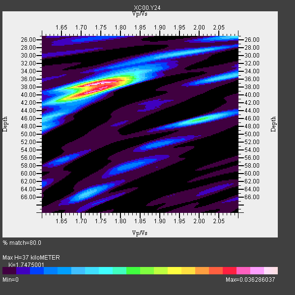
| Thickness Estimate: | 37 km |
| Thickness StdDev: | 1.6 km |
| Vp/Vs Estimate: | 1.75 |
| Vp/Vs StdDev: | 0.03 |
| Vs Estimate: | 3.764 km/s |
| Poisson's Ratio: | 0.26 |
| Peak Value: | 0.04 |
| Assumed Vp: | 6.577 km/s |
| Ps Weight: | 0.33333334 |
| PpPs Weight: | 0.33333334 |
| PsPs Weight: | 0.33333328 |
| Residual Complexity: | 0.563 |
| Nearby stations H: | +- |
| (2.0 deg) Vp/Vs: | +- |
2 with match > 90% ( 16.666666 %) and 12 with match > 80% ( 100.0 %) out of 12.
Download stack as xyz text file.
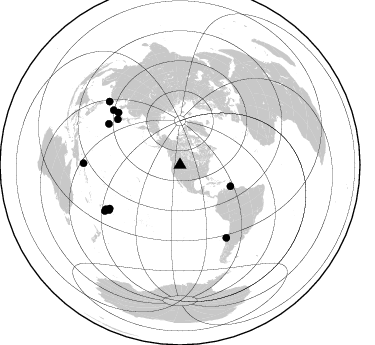
Azimuth Distribution of Events:
Prior Results for this Station
| Study | Thickness | Vp/Vs | Vp | Vs | Poissons Ratio | Extra |
| EARS | 37 km | 1.75 | 6.577 km/s | 3.764 km/s | 0.26 | |
| Crust2.0 | 46 km | 1.78 | 6.577 km/s | 3.701 km/s | 0.27 | H3,early/mid Proter. shield, Finland, 0.5 km seds. |
| Global Maxima | 37 km | 1.75 | 6.577 km/s | 3.764 km/s | 0.26 | amp=0.036286037 |
| Local Maxima 1 | 39 km | 1.72 | 6.577 km/s | 3.824 km/s | 0.24 | amp=0.024671603 |
| Local Maxima 2 | 46 km | 2.01 | 6.577 km/s | 3.28 km/s | 0.33 | amp=0.017874002 |
| Local Maxima 3 | 25 km | 2.10 | 6.577 km/s | 3.136 km/s | 0.35 | amp=0.0116973845 |
| Local Maxima 4 | 65 km | 1.71 | 6.577 km/s | 3.841 km/s | 0.24 | amp=0.011168467 |
| Predicted Arrivals for vertical incidence (zero ray parameter) | |
| Ps | 4.21 SECOND |
| PpPs | 15.46 SECOND |
| PsPs/PpSs | 19.66 SECOND |
Events Processed for this Station
Download zip of receiver functions as SAC
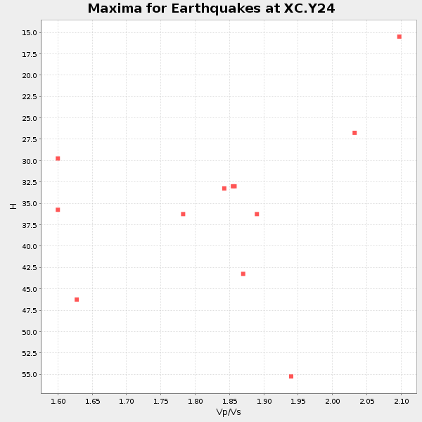
Plot maxima for each earthquake.
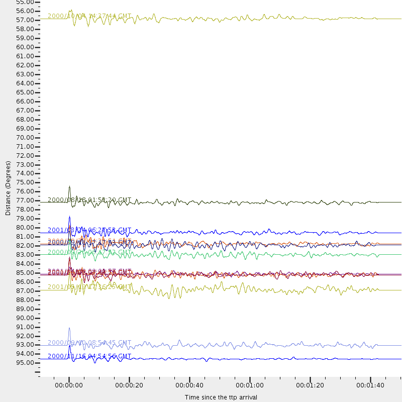
Events Used in the Stack
(12 events)| Radial Match | Distance | Baz | FERegion | Time | Lat/Lon | Depth | Magnitude |
| 91.925995 | 81.0 deg | 310.318 deg | Western Honshu, Japan | 2001/03/24 06:27:53 GMT | (34.1, 132.5) | 50 km | 6.4 MB, 6.5 MS, 6.8 MW, 6.4 ME |
| 90.427505 | 83.7 deg | 237.531 deg | Tonga Islands | 2000/09/26 06:17:52 GMT | (-17.2, -173.9) | 56 km | 6.1 MB, 6.1 MS, 6.4 MW, 6.1 ME |
| 89.14212 | 86.1 deg | 147.463 deg | Off Coast Of Central Chile | 2001/04/09 09:00:57 GMT | (-32.7, -73.1) | 11 km | 6.1 MB, 6.3 MS, 6.7 MW, 6.3 ME |
| 88.83263 | 54.8 deg | 112.91 deg | Windward Islands | 2000/10/04 14:37:44 GMT | (11.1, -62.6) | 110 km | 5.6 MB, 5.4 MS, 6.1 MW, 5.9 MD |
| 88.67752 | 82.3 deg | 299.916 deg | Bonin Islands, Japan Region | 2000/10/27 04:21:51 GMT | (26.3, 140.5) | 388 km | 6.1 MB, 6.1 MW, 6.0 MW |
| 86.658264 | 96.5 deg | 270.976 deg | New Ireland Region, P.N.G. | 2000/11/16 04:54:56 GMT | (-4.0, 152.2) | 33 km | 6.0 MB, 8.2 MS, 8.0 MW, 8.0 ME |
| 86.59768 | 86.2 deg | 309.525 deg | Ryukyu Islands, Japan | 2000/10/02 07:44:10 GMT | (29.5, 129.4) | 33 km | 5.6 MB, 5.2 MS, 5.6 MW, 5.5 MW |
| 86.44355 | 77.3 deg | 306.125 deg | Near S. Coast Of Honshu, Japan | 2000/08/18 01:52:20 GMT | (34.1, 139.2) | 10 km | 5.6 MB, 5.5 MS, 5.8 MW, 5.7 MW |
| 84.87704 | 82.5 deg | 238.153 deg | Tonga Islands | 2000/09/11 17:17:53 GMT | (-15.9, -173.7) | 115 km | 6.0 MB, 6.3 MW, 6.3 MW |
| 83.118004 | 87.9 deg | 238.505 deg | Fiji Islands Region | 2001/05/19 17:36:25 GMT | (-19.9, -177.5) | 369 km | 5.9 MB, 6.0 MW, 5.9 MW |
| 83.08921 | 86.2 deg | 239.235 deg | Fiji Islands Region | 2001/04/28 04:49:53 GMT | (-18.1, -176.9) | 352 km | 6.2 MB, 6.8 MW, 6.8 MW |
| 80.10905 | 94.8 deg | 311.947 deg | Taiwan | 2000/09/10 08:54:45 GMT | (24.0, 121.5) | 35 km | 5.6 MB, 5.6 MS, 5.8 MW, 5.8 MW |
Losers
(0 events)| Radial Match | Distance | Baz | FERegion | Time | Lat/Lon | Depth | Magnitude | Reason |
