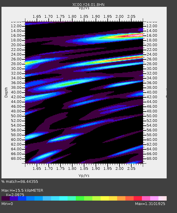
Y24 Y24 - Earthquake Result Viewer
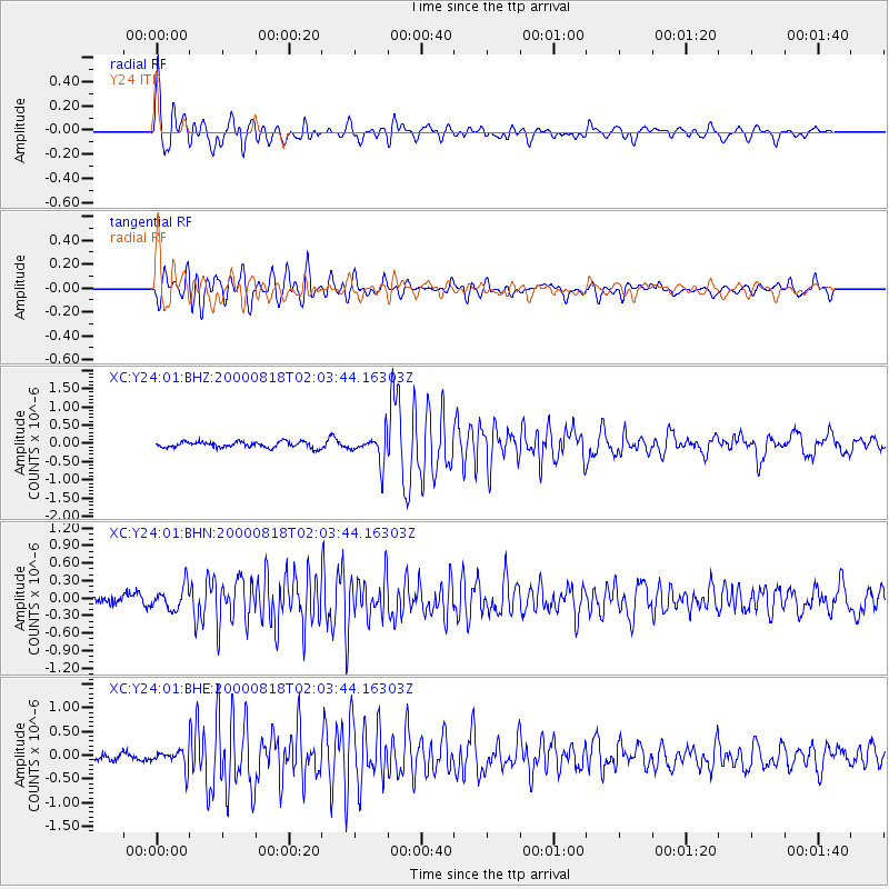
Earthquake location: Near S. Coast Of Honshu, Japan
Earthquake latitude/longitude: 34.1/139.2
Earthquake time(UTC): 2000/08/18 (231) 01:52:20 GMT
Earthquake Depth: 10 km
Earthquake Magnitude: 5.6 MB, 5.5 MS, 5.8 MW, 5.7 MW
Earthquake Catalog/Contributor: WHDF/NEIC
Network: XC Yellowstone Intermountain Seismic Array
Station: Y24 Y24
Lat/Lon: 45.98 N/112.62 W
Elevation: 1741 m
Distance: 77.3 deg
Az: 42.763 deg
Baz: 306.125 deg
Ray Param: 0.05040528
Estimated Moho Depth: 15.5 km
Estimated Crust Vp/Vs: 2.10
Assumed Crust Vp: 6.577 km/s
Estimated Crust Vs: 3.136 km/s
Estimated Crust Poisson's Ratio: 0.35
Radial Match: 86.44355 %
Radial Bump: 400
Transverse Match: 82.496826 %
Transverse Bump: 400
SOD ConfigId: 16820
Insert Time: 2010-02-26 15:02:12.995 +0000
GWidth: 2.5
Max Bumps: 400
Tol: 0.001

Signal To Noise

ChannelStoNSTALTA
XC:Y24:01:BHN:20000818T02:03:44.16303Z2.15535262.0229636E-79.3857665E-8
XC:Y24:01:BHE:20000818T02:03:44.16303Z1.79319561.8087721E-71.0086865E-7
XC:Y24:01:BHZ:20000818T02:03:44.16303Z4.7845453.933416E-78.221087E-8
Arrivals
Ps2.7 SECOND
PpPs7.1 SECOND
PsPs/PpSs9.8 SECOND