You are here: Home > Network List > XC00 - Yellowstone Intermountain Seismic Array Stations List
> Station Y24 Y24 > Earthquake Result Viewer
Y24 Y24 - Earthquake Result Viewer
| Earthquake location: |
Fiji Islands Region |
| Earthquake latitude/longitude: |
-19.9/-177.5 |
| Earthquake time(UTC): |
2001/05/19 (139) 17:36:25 GMT |
| Earthquake Depth: |
369 km |
| Earthquake Magnitude: |
5.9 MB, 6.0 MW, 5.9 MW |
| Earthquake Catalog/Contributor: |
WHDF/NEIC |
|
| Network: |
XC Yellowstone Intermountain Seismic Array |
| Station: |
Y24 Y24 |
| Lat/Lon: |
45.98 N/112.62 W |
| Elevation: |
1741 m |
|
| Distance: |
87.9 deg |
| Az: |
39.187 deg |
| Baz: |
238.505 deg |
| Ray Param: |
0.04201108 |
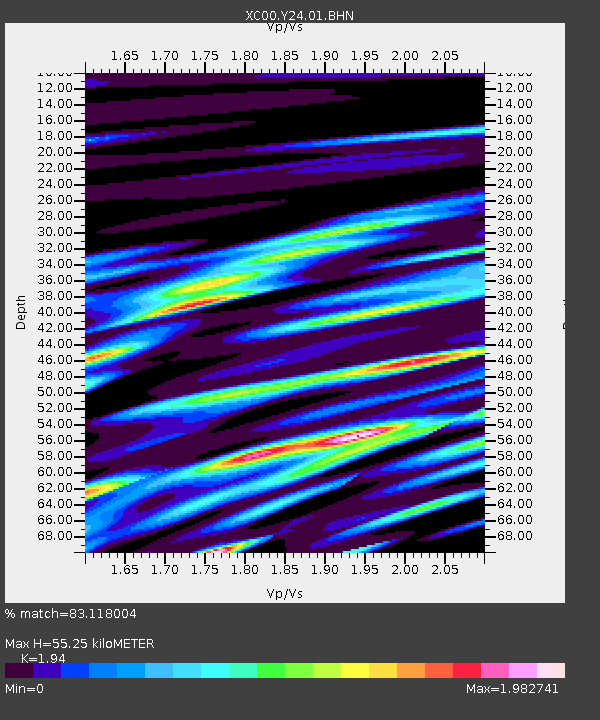
| Estimated Moho Depth: |
55.25 km |
| Estimated Crust Vp/Vs: |
1.94 |
| Assumed Crust Vp: |
6.577 km/s |
| Estimated Crust Vs: |
3.39 km/s |
| Estimated Crust Poisson's Ratio: |
0.32 |
|
| Radial Match: |
83.118004 % |
| Radial Bump: |
400 |
| Transverse Match: |
73.02815 % |
| Transverse Bump: |
400 |
| SOD ConfigId: |
4714 |
| Insert Time: |
2010-02-26 15:02:18.045 +0000 |
| GWidth: |
2.5 |
| Max Bumps: |
400 |
| Tol: |
0.001 |
|

Signal To Noise
| Channel | StoN | STA | LTA |
| XC:Y24:01:BHN:20010519T17:48:03.298008Z | 2.7291114 | 4.1203728E-7 | 1.5097854E-7 |
| XC:Y24:01:BHE:20010519T17:48:03.298008Z | 5.96117 | 9.91096E-7 | 1.6625863E-7 |
| XC:Y24:01:BHZ:20010519T17:48:03.298008Z | 12.6053 | 1.5060407E-6 | 1.1947678E-7 |
| Arrivals |
| Ps | 8.1 SECOND |
| PpPs | 24 SECOND |
| PsPs/PpSs | 32 SECOND |


