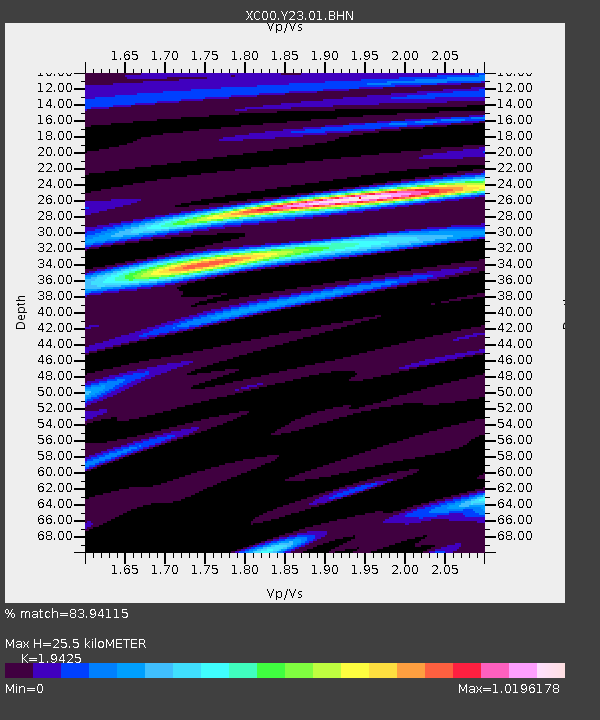
Y23 Y23 - Earthquake Result Viewer
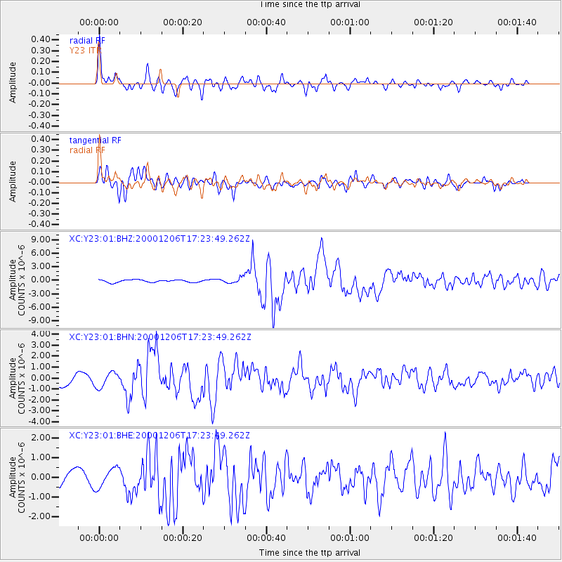
Earthquake location: Turkmenistan
Earthquake latitude/longitude: 39.6/54.8
Earthquake time(UTC): 2000/12/06 (341) 17:11:06 GMT
Earthquake Depth: 30 km
Earthquake Magnitude: 6.7 MB, 7.5 MS, 7.0 MW, 6.9 ME
Earthquake Catalog/Contributor: WHDF/NEIC
Network: XC Yellowstone Intermountain Seismic Array
Station: Y23 Y23
Lat/Lon: 46.28 N/112.93 W
Elevation: 1651 m
Distance: 93.8 deg
Az: 351.501 deg
Baz: 9.481 deg
Ray Param: 0.041172467
Estimated Moho Depth: 25.5 km
Estimated Crust Vp/Vs: 1.94
Assumed Crust Vp: 6.353 km/s
Estimated Crust Vs: 3.271 km/s
Estimated Crust Poisson's Ratio: 0.32
Radial Match: 83.94115 %
Radial Bump: 400
Transverse Match: 78.411354 %
Transverse Bump: 400
SOD ConfigId: 16820
Insert Time: 2010-02-26 15:02:19.657 +0000
GWidth: 2.5
Max Bumps: 400
Tol: 0.001

Signal To Noise

ChannelStoNSTALTA
XC:Y23:01:BHN:20001206T17:23:49.262Z1.65595486.8243344E-74.121087E-7
XC:Y23:01:BHE:20001206T17:23:49.262Z1.11079054.9443645E-74.4512123E-7
XC:Y23:01:BHZ:20001206T17:23:49.262Z2.1876786.027979E-72.755423E-7
Arrivals
Ps3.9 SECOND
PpPs12 SECOND
PsPs/PpSs15 SECOND