
Station XC Y23 - Y23
Network: XC00 - Yellowstone Intermountain Seismic Array
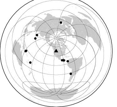
Nearby stations (2 deg radius)
| Station | Name | (Lat, Lon) | Start / End | Elevation |
| Y23 | Y23 | (46.28, -112.93) | 2000-07-14 / 2001-12-31 | 1651 m |
| Crust2 Type: | PE,orogen/50km, Tibet, 0.5 km seds. |
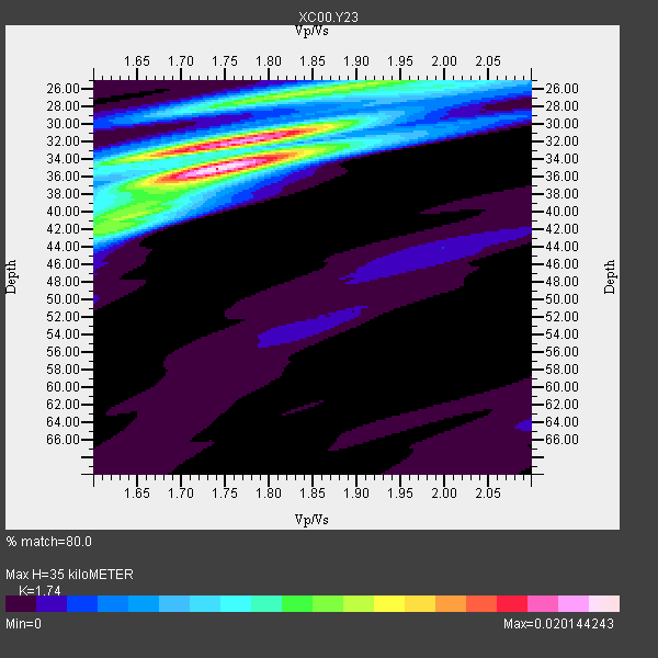
| Thickness Estimate: | 35 km |
| Thickness StdDev: | 3.8 km |
| Vp/Vs Estimate: | 1.74 |
| Vp/Vs StdDev: | 0.08 |
| Vs Estimate: | 3.651 km/s |
| Poisson's Ratio: | 0.25 |
| Peak Value: | 0.02 |
| Assumed Vp: | 6.353 km/s |
| Ps Weight: | 0.33333334 |
| PpPs Weight: | 0.33333334 |
| PsPs Weight: | 0.33333328 |
| Residual Complexity: | 0.652 |
| Nearby stations H: | +- |
| (2.0 deg) Vp/Vs: | +- |
3 with match > 90% ( 27.272728 %) and 11 with match > 80% ( 100.0 %) out of 11.
Download stack as xyz text file.
Azimuth Distribution of Events:
Prior Results for this Station
| Study | Thickness | Vp/Vs | Vp | Vs | Poissons Ratio | Extra |
| EARS | 35 km | 1.74 | 6.353 km/s | 3.651 km/s | 0.25 | |
| Crust2.0 | 50 km | 1.76 | 6.353 km/s | 3.612 km/s | 0.26 | PE,orogen/50km, Tibet, 0.5 km seds. |
| Global Maxima | 35 km | 1.74 | 6.353 km/s | 3.651 km/s | 0.25 | amp=0.020144243 |
| Local Maxima 1 | 32 km | 1.75 | 6.353 km/s | 3.641 km/s | 0.26 | amp=0.015547869 |
| Local Maxima 2 | 26 km | 1.83 | 6.353 km/s | 3.476 km/s | 0.29 | amp=0.011270381 |
| Local Maxima 3 | 42 km | 1.60 | 6.353 km/s | 3.971 km/s | 0.18 | amp=0.0079658935 |
| Local Maxima 4 | 40 km | 1.63 | 6.353 km/s | 3.886 km/s | 0.20 | amp=0.005947928 |
| Predicted Arrivals for vertical incidence (zero ray parameter) | |
| Ps | 4.08 SECOND |
| PpPs | 15.10 SECOND |
| PsPs/PpSs | 19.17 SECOND |
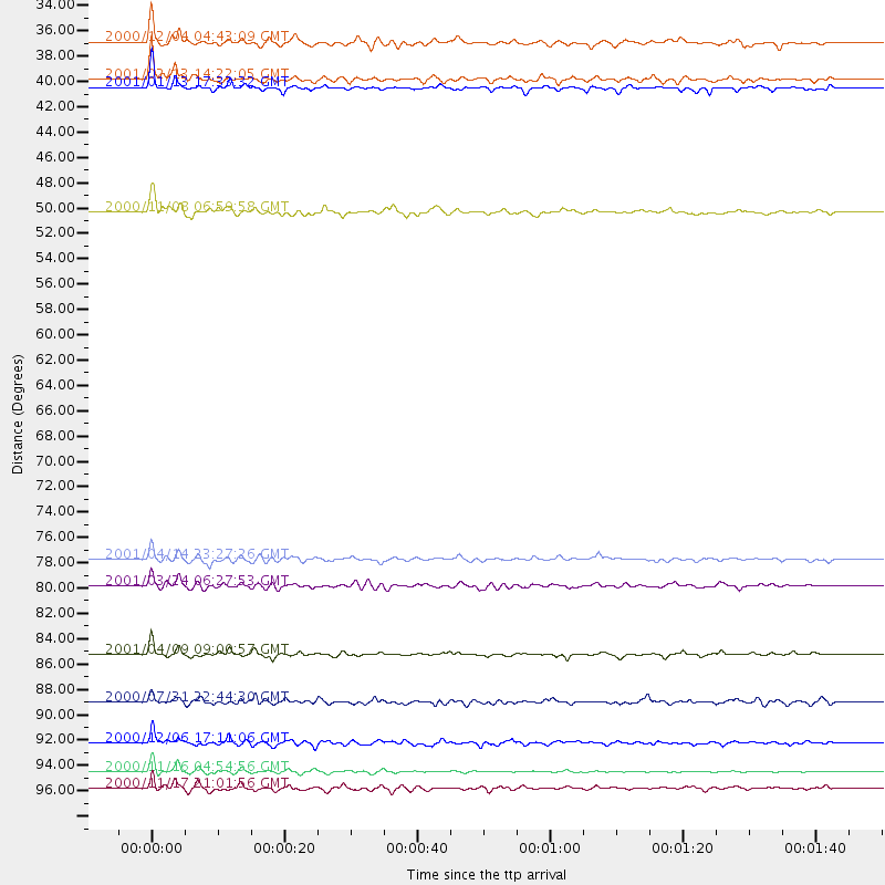
Events Processed for this Station
Download zip of receiver functions as SAC
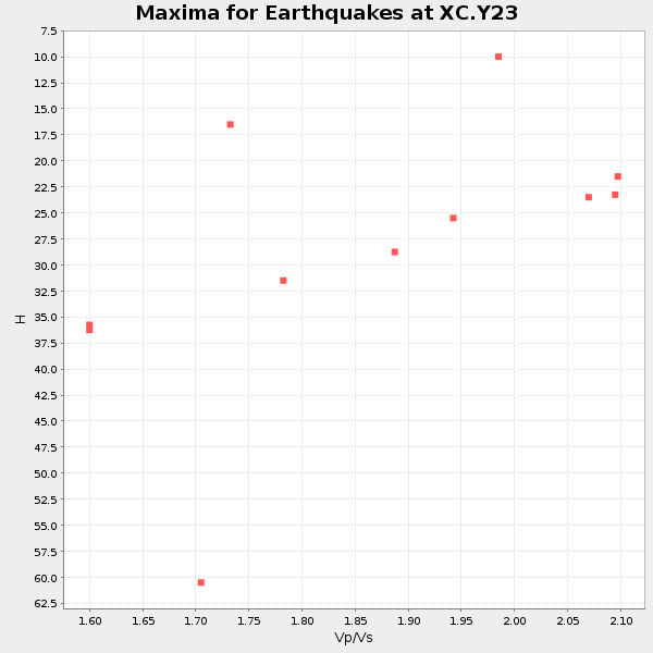
Plot maxima for each earthquake.
Events Used in the Stack
(11 events)| Radial Match | Distance | Baz | FERegion | Time | Lat/Lon | Depth | Magnitude |
| 94.23593 | 38.9 deg | 140.417 deg | El Salvador | 2001/01/13 17:33:32 GMT | (13.0, -88.7) | 60 km | 6.4 MB, 7.8 MS, 7.7 MW, 7.5 ME |
| 91.76158 | 86.4 deg | 147.239 deg | Off Coast Of Central Chile | 2001/04/09 09:00:57 GMT | (-32.7, -73.1) | 11 km | 6.1 MB, 6.3 MS, 6.7 MW, 6.3 ME |
| 90.45913 | 96.2 deg | 270.786 deg | New Ireland Region, P.N.G. | 2000/11/16 04:54:56 GMT | (-4.0, 152.2) | 33 km | 6.0 MB, 8.2 MS, 8.0 MW, 8.0 ME |
| 89.24691 | 80.6 deg | 310.081 deg | Western Honshu, Japan | 2001/03/24 06:27:53 GMT | (34.1, 132.5) | 50 km | 6.4 MB, 6.5 MS, 6.8 MW, 6.4 ME |
| 86.50242 | 49.4 deg | 131.255 deg | Panama-Colombia Border Region | 2000/11/08 06:59:58 GMT | (7.0, -77.8) | 17 km | 6.0 MB, 6.4 MS, 6.5 MW, 6.2 ML |
| 85.565575 | 38.3 deg | 140.353 deg | El Salvador | 2001/02/13 14:22:05 GMT | (13.7, -88.9) | 10 km | 5.5 MB, 6.5 MS, 6.6 MW, 6.1 MD |
| 85.2218 | 97.6 deg | 270.01 deg | New Britain Region, P.N.G. | 2000/11/17 21:01:56 GMT | (-5.5, 151.8) | 33 km | 6.2 MB, 8.0 MS, 7.6 MW, 6.9 ME |
| 84.18305 | 35.1 deg | 146.862 deg | Near Coast Of Chiapas, Mexico | 2000/12/04 04:43:09 GMT | (14.9, -93.9) | 33 km | 5.6 MB, 5.7 MS, 6.0 MW, 5.9 MW |
| 83.94115 | 93.8 deg | 9.481 deg | Turkmenistan | 2000/12/06 17:11:06 GMT | (39.6, 54.8) | 30 km | 6.7 MB, 7.5 MS, 7.0 MW, 6.9 ME |
| 83.281815 | 90.4 deg | 246.091 deg | Fiji Islands Region | 2000/07/31 22:44:30 GMT | (-16.7, 174.5) | 10 km | 5.7 MB, 5.6 MS, 6.1 MW, 6.1 MW |
| 83.02448 | 78.4 deg | 301.428 deg | Southeast Of Honshu, Japan | 2001/04/14 23:27:26 GMT | (30.1, 141.8) | 10 km | 6.0 MB, 5.8 MS, 6.0 MW, 6.0 ME |
Losers
(0 events)| Radial Match | Distance | Baz | FERegion | Time | Lat/Lon | Depth | Magnitude | Reason |
