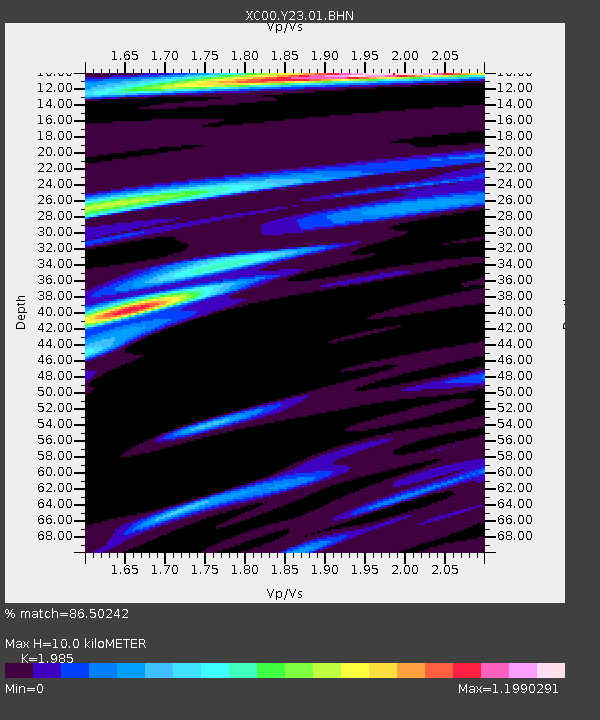
Y23 Y23 - Earthquake Result Viewer
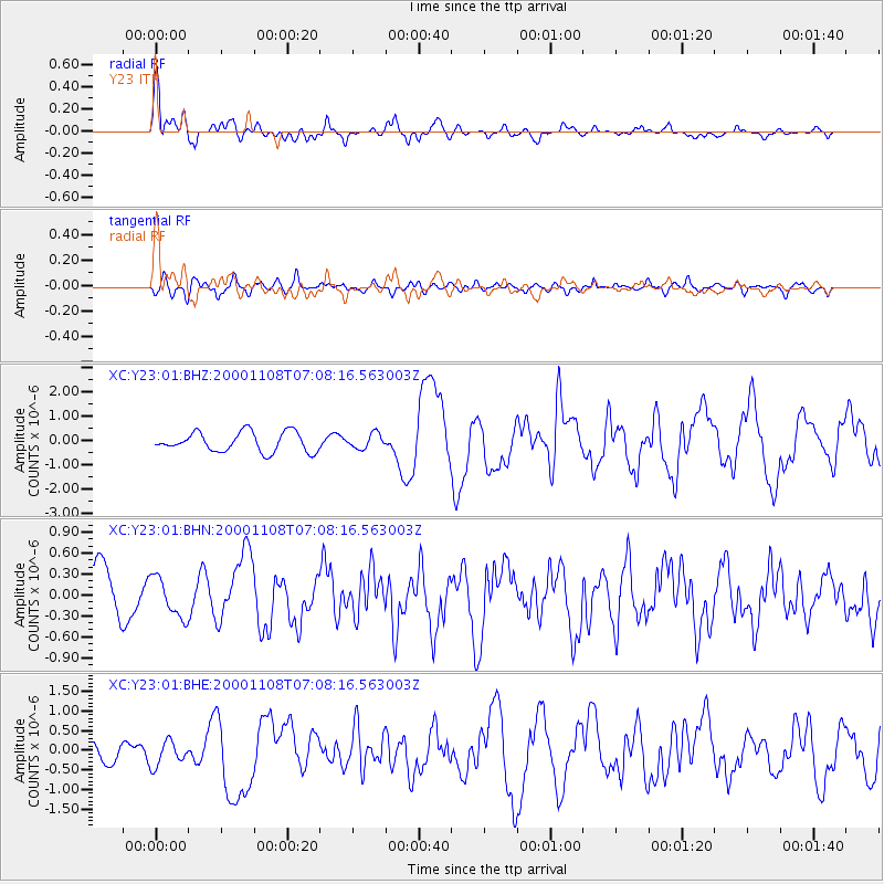
Earthquake location: Panama-Colombia Border Region
Earthquake latitude/longitude: 7.0/-77.8
Earthquake time(UTC): 2000/11/08 (313) 06:59:58 GMT
Earthquake Depth: 17 km
Earthquake Magnitude: 6.0 MB, 6.4 MS, 6.5 MW, 6.2 ML
Earthquake Catalog/Contributor: WHDF/NEIC
Network: XC Yellowstone Intermountain Seismic Array
Station: Y23 Y23
Lat/Lon: 46.28 N/112.93 W
Elevation: 1651 m
Distance: 49.4 deg
Az: 328.31 deg
Baz: 131.255 deg
Ray Param: 0.068716824
Estimated Moho Depth: 10.0 km
Estimated Crust Vp/Vs: 1.99
Assumed Crust Vp: 6.353 km/s
Estimated Crust Vs: 3.201 km/s
Estimated Crust Poisson's Ratio: 0.33
Radial Match: 86.50242 %
Radial Bump: 400
Transverse Match: 45.7003 %
Transverse Bump: 400
SOD ConfigId: 16820
Insert Time: 2010-02-26 15:02:22.318 +0000
GWidth: 2.5
Max Bumps: 400
Tol: 0.001

Signal To Noise

ChannelStoNSTALTA
XC:Y23:01:BHN:20001108T07:08:16.563003Z0.613788962.8553535E-74.6520117E-7
XC:Y23:01:BHE:20001108T07:08:16.563003Z1.36160353.1330455E-72.3009969E-7
XC:Y23:01:BHZ:20001108T07:08:16.563003Z0.761947933.0632776E-74.020324E-7
Arrivals
Ps1.6 SECOND
PpPs4.5 SECOND
PsPs/PpSs6.1 SECOND