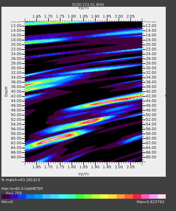
Y23 Y23 - Earthquake Result Viewer
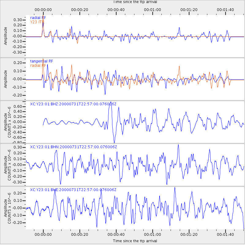
Earthquake location: Fiji Islands Region
Earthquake latitude/longitude: -16.7/174.5
Earthquake time(UTC): 2000/07/31 (213) 22:44:30 GMT
Earthquake Depth: 10 km
Earthquake Magnitude: 5.7 MB, 5.6 MS, 6.1 MW, 6.1 MW
Earthquake Catalog/Contributor: WHDF/NEIC
Network: XC Yellowstone Intermountain Seismic Array
Station: Y23 Y23
Lat/Lon: 46.28 N/112.93 W
Elevation: 1651 m
Distance: 90.4 deg
Az: 41.422 deg
Baz: 246.091 deg
Ray Param: 0.04167932
Estimated Moho Depth: 60.5 km
Estimated Crust Vp/Vs: 1.71
Assumed Crust Vp: 6.353 km/s
Estimated Crust Vs: 3.726 km/s
Estimated Crust Poisson's Ratio: 0.24
Radial Match: 83.281815 %
Radial Bump: 400
Transverse Match: 72.38873 %
Transverse Bump: 400
SOD ConfigId: 3744
Insert Time: 2010-02-26 15:02:25.647 +0000
GWidth: 2.5
Max Bumps: 400
Tol: 0.001

Signal To Noise

ChannelStoNSTALTA
XC:Y23:01:BHN:20000731T22:57:00.076006Z1.12548515.71965E-85.0819423E-8
XC:Y23:01:BHE:20000731T22:57:00.076006Z0.789968134.4343402E-85.613315E-8
XC:Y23:01:BHZ:20000731T22:57:00.076006Z2.39748261.2871077E-75.3685795E-8
Arrivals
Ps6.9 SECOND
PpPs25 SECOND
PsPs/PpSs32 SECOND