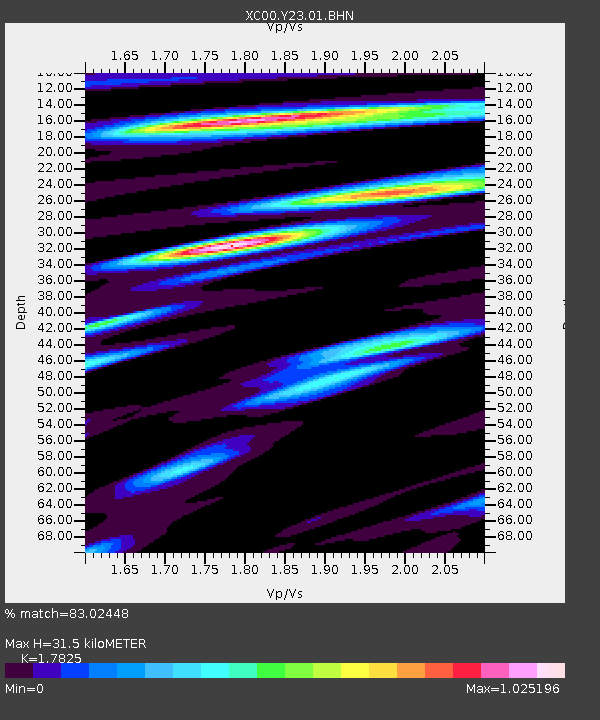
Y23 Y23 - Earthquake Result Viewer
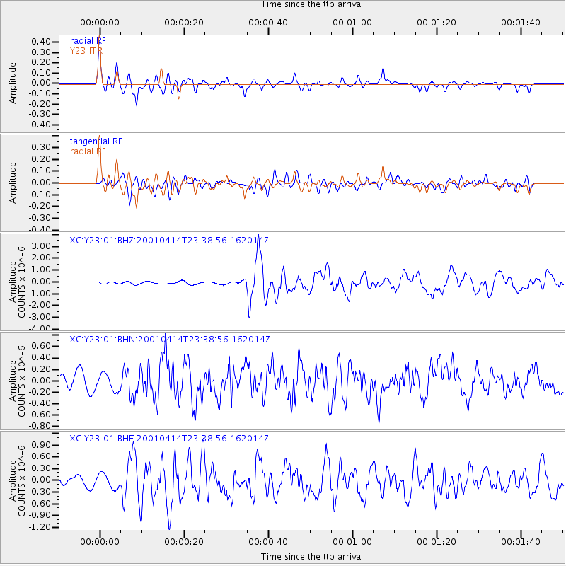
Earthquake location: Southeast Of Honshu, Japan
Earthquake latitude/longitude: 30.1/141.8
Earthquake time(UTC): 2001/04/14 (104) 23:27:26 GMT
Earthquake Depth: 10 km
Earthquake Magnitude: 6.0 MB, 5.8 MS, 6.0 MW, 6.0 ME
Earthquake Catalog/Contributor: WHDF/NEIC
Network: XC Yellowstone Intermountain Seismic Array
Station: Y23 Y23
Lat/Lon: 46.28 N/112.93 W
Elevation: 1651 m
Distance: 78.4 deg
Az: 43.067 deg
Baz: 301.428 deg
Ray Param: 0.049652442
Estimated Moho Depth: 31.5 km
Estimated Crust Vp/Vs: 1.78
Assumed Crust Vp: 6.353 km/s
Estimated Crust Vs: 3.564 km/s
Estimated Crust Poisson's Ratio: 0.27
Radial Match: 83.02448 %
Radial Bump: 400
Transverse Match: 63.668793 %
Transverse Bump: 400
SOD ConfigId: 16820
Insert Time: 2010-02-26 15:02:26.822 +0000
GWidth: 2.5
Max Bumps: 400
Tol: 0.001

Signal To Noise

ChannelStoNSTALTA
XC:Y23:01:BHN:20010414T23:38:56.162014Z1.18666241.4176375E-71.1946426E-7
XC:Y23:01:BHE:20010414T23:38:56.162014Z1.90153221.8063429E-79.499407E-8
XC:Y23:01:BHZ:20010414T23:38:56.162014Z1.38388481.4913732E-71.0776715E-7
Arrivals
Ps4.0 SECOND
PpPs13 SECOND
PsPs/PpSs17 SECOND