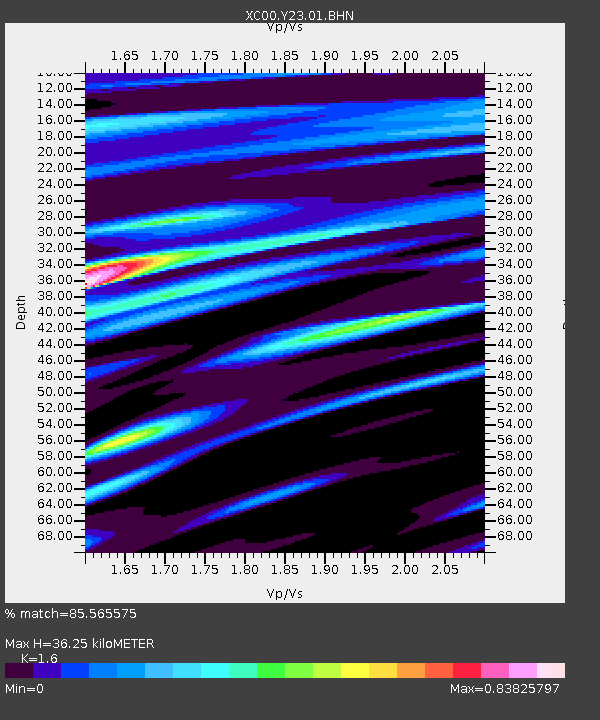
Y23 Y23 - Earthquake Result Viewer
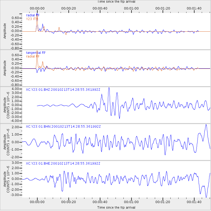
Earthquake location: El Salvador
Earthquake latitude/longitude: 13.7/-88.9
Earthquake time(UTC): 2001/02/13 (044) 14:22:05 GMT
Earthquake Depth: 10 km
Earthquake Magnitude: 5.5 MB, 6.5 MS, 6.6 MW, 6.1 MD
Earthquake Catalog/Contributor: WHDF/NEIC
Network: XC Yellowstone Intermountain Seismic Array
Station: Y23 Y23
Lat/Lon: 46.28 N/112.93 W
Elevation: 1651 m
Distance: 38.3 deg
Az: 332.918 deg
Baz: 140.353 deg
Ray Param: 0.07566042
Estimated Moho Depth: 36.25 km
Estimated Crust Vp/Vs: 1.60
Assumed Crust Vp: 6.353 km/s
Estimated Crust Vs: 3.971 km/s
Estimated Crust Poisson's Ratio: 0.18
Radial Match: 85.565575 %
Radial Bump: 337
Transverse Match: 73.34627 %
Transverse Bump: 381
SOD ConfigId: 3744
Insert Time: 2010-02-26 15:02:31.190 +0000
GWidth: 2.5
Max Bumps: 400
Tol: 0.001

Signal To Noise

ChannelStoNSTALTA
XC:Y23:01:BHN:20010213T14:28:55.361992Z1.60336572.5082124E-71.5643423E-7
XC:Y23:01:BHE:20010213T14:28:55.361992Z0.95322641.1495358E-71.2059421E-7
XC:Y23:01:BHZ:20010213T14:28:55.361992Z2.14604853.1146305E-71.4513327E-7
Arrivals
Ps3.7 SECOND
PpPs14 SECOND
PsPs/PpSs17 SECOND