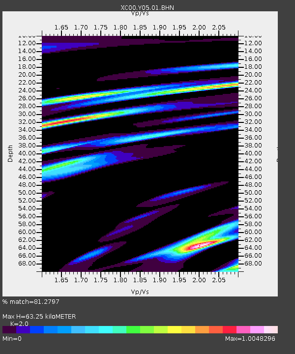
Y05 Y05 - Earthquake Result Viewer
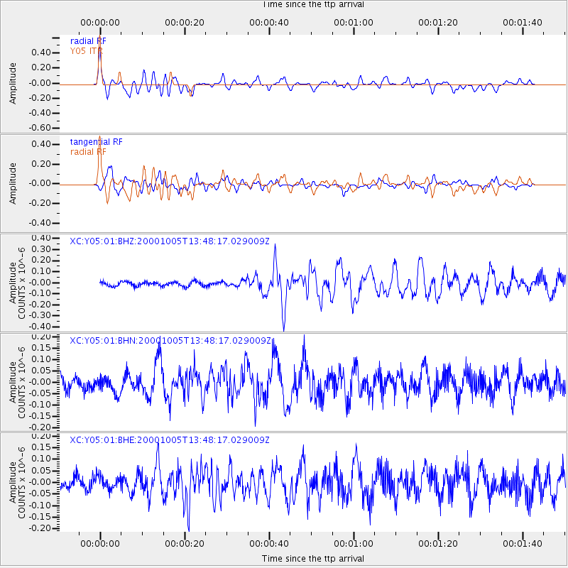
Earthquake location: Northern Mid-Atlantic Ridge
Earthquake latitude/longitude: 31.7/-41.0
Earthquake time(UTC): 2000/10/05 (279) 13:39:11 GMT
Earthquake Depth: 10 km
Earthquake Magnitude: 5.4 MB, 6.1 MS, 6.0 MW, 5.9 MW
Earthquake Catalog/Contributor: WHDF/NEIC
Network: XC Yellowstone Intermountain Seismic Array
Station: Y05 Y05
Lat/Lon: 43.19 N/111.58 W
Elevation: 1970 m
Distance: 55.7 deg
Az: 303.35 deg
Baz: 76.699 deg
Ray Param: 0.06462951
Estimated Moho Depth: 63.25 km
Estimated Crust Vp/Vs: 2.00
Assumed Crust Vp: 6.207 km/s
Estimated Crust Vs: 3.103 km/s
Estimated Crust Poisson's Ratio: 0.33
Radial Match: 81.2797 %
Radial Bump: 400
Transverse Match: 79.13639 %
Transverse Bump: 400
SOD ConfigId: 3744
Insert Time: 2010-02-26 15:02:36.246 +0000
GWidth: 2.5
Max Bumps: 400
Tol: 0.001

Signal To Noise

ChannelStoNSTALTA
XC:Y05:01:BHN:20001005T13:48:17.029009Z1.31591264.0950688E-83.1119612E-8
XC:Y05:01:BHE:20001005T13:48:17.029009Z1.02933972.8546154E-82.7732494E-8
XC:Y05:01:BHZ:20001005T13:48:17.029009Z1.18414752.4264544E-82.049115E-8
Arrivals
Ps11 SECOND
PpPs29 SECOND
PsPs/PpSs40 SECOND